Тип бассейна:
Подтип бассейна:
Класс бассейна:
Возраст бассейна:
Тип полезных ископаемых:
Геологический возраст начало:
Геологический возраст конец:
Площадь: 654988.56 км²
Mozambique Basin
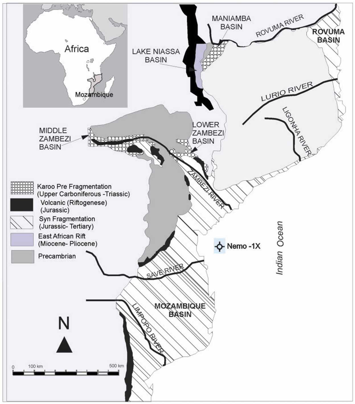
Mozambique, as an emerging African country is currently undertaking intense research and exploration of its natural resources, especially for hydrocarbons. Of the six major sedimen tary basins in Mozambique (Figure 1) this activity is focused on two large basins: the Mozambique Basin in the central and southern part of the country and the Rovuma Basin in the north (Figure 1). A general discussion on the hydrocarbon potential of the Mozambique Basin was pub lished by Alan et al. (1991) and Iliffe et al. (1991). They used Royden’s model to determine the maturation and concluded that a source rock which reaches maturity for hydrocarbon generation likely lies somewhere within the Lower Cretaceous or Jurassic strata. The prob ability of such a source rock being present is enhanced by the high marine/terrigenous shale depositional setting envisaged for these strata. The reservoirs may be present in Cretaceous rocks and regardless of the model used or the heat flow history configuration applied, the basin is expected to have mature hydrocar bon source rocks in the eastern part at depths of 3000–4000 m. The ideal situation of the relative timing of source deposition followed by faulting, seal deposition, and maturation of the source rocks seems to be the case in the South Mozambique Graben (Alan et al., 1991; Iliffe et al., 1991). According to Michael (2016), the Mozambique Coastal Province contained only five gas accumulations exceeding the minimum size of 30 billion cubic feet of gas. This prov ince is considered to be underexplored on the basis of its level of exploration activity. Using a geology-based assessment, the United States Geological Survey (USGS) estimated mean volumes of undiscovered, technically recoverable conventional oil and gas resources for the Mesozoic–Cenozoic Reservoirs Assessment Unit in the Mozambique Coastal Province. The mean volumes are estimated at 11.682 million barrels of oil, 182.349 billion cubic feet of gas, and 5.645 million barrels of natural gas liquids. The estimated mean size of the largest oil field that is expected to be discovered is 1.041 million barrels of oil and the estimated mean size of the expected largest gas field is 7.976 billion cubic feet of gas. For this assessment, a minimum undiscovered field size of 5 million barrels of oil equiv alent was used by Michael (2016).
Figure 1. Map showing the six sedimentary basins of Mozambique (ECL, 2000) and the Nemo-1X well location investigated in the present study.
In the Mozambique Basin previous geochemical studies on the Nemo-1X well (Lineback et al., 1986) indicated the predominance of kerogen type III suggesting a continental depo sitional environment. This study also showed that based on vitrinite reflectances the thermal maturity of the organic matter in well Nemo-1X ranges from immature to the peak oil generation window. However, relatively low hydrogen indexes as determined by Rock-Eval Pyrolysis suggest that hydrocarbon generation is restricted to gas generation potential in samples analyzed from the Cretaceous Lower Domo Shale Formation (Lineback et al., 1986).
Geological setting
The Mozambique Basin occupies the central and southern parts of Mozambique, extending onto the continental shelf and slope (Figure 1). The sedimentary fill is composed of Upper Jurassic, Cretaceous, and Cenozoic rocks which overlie “Karoo” volcanics. It covers an area of approximately 500,000 km2, of which 275,000 km2 are onshore and 225,000 km2 offshore to the 2000 m isobaths (ECL, 2000). The basin forms a large asymmetric depression, inclined eastward and flanked by crystalline Pre-Cambrian basement or by the Karoo basalts (Salman et al., 1990).
The peculiarities of the tectonic structure are determined by the relationship between the several phases of structural development:
the Mozambique Basin is part of the East African continental margin system, whose formation can be traced from the Late Jurassic/Early Cretaceous;
• the structures of the basin overlie the more ancient structural elements of the Gondwanaland intracratonic trough and the Karoo grabens;
• the pericontinental depression overlies the rift structures of the early riftogenic stage (Late Jurassic/Early Cretaceous);
• the basin is located at the southern end of the East African Rift, which is dated as neo riftogenic stage (Late Cretaceous–Cenozoic) (Salman et al., 1990).
The following structural stages have been identified in the tectonic structure of the Mozambique Basin, reflecting the main stages in the geological history of the basin:
• pre-Cambrian crystalline basement; Gondwana structural stage (Karoo) and post Gondwana stage (Upper Jurassic Cenozoic) (Salman et al., 1990).
The stratigraphic sequence of the basin (Figure 2) is comprised of Cenozoic, Cretaceous, and Upper Jurassic sedimentary rocks, as well as igneous rocks of the Karoo (Salman and Abdula, 1995).
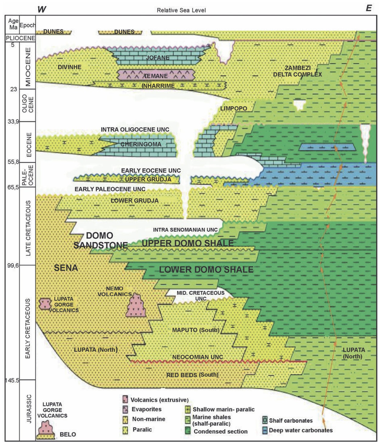
Figure 2. General stratigraphy of the Jurassic to Tertiary strata of the Mozambique Basin (ECL, 2000)
Stratigraphically (from bottom to top), the Mozambique Basin has the following geo logical formations (Figure 2): Red Beds, Lupata, Maputo, Sena, Lower Domo Shale, Domo Sand, Upper Domo Shale, Lower Grudja, Upper Grudja, Cheringoma, Zambezi Deltaic Complex, Inharrime, Temane, Jofane (ECL, 2000). Lithologies and depositional environ ments of these formations are discussed briefly below based on studies by ECL (2000), Salman and Abdula (1995), and Salman et al. (1990).
The basal Red Beds Formation (Figure 2) represents the initial flooding of the shelf in the Late Jurassic and subsequent deposition of the first true drift deposits. The top of this sequence is represented by the “brown” horizon designated as the “Mid-Cretaceous Unconformity” which in the Zambezi Depression marks the transition from the Lupata Formation to the Lower Domo Shale (ECL, 2000).
The Lupata Formation (Figure 2) is developed in the NW part of the basin within the limits of the Zambezi Graben. This section is an eroded basalt surface and it comprises multicolored conglomerates and sandstones with large gneiss and Karoo rock fragments. These sediments are interbedded with rhyolite lavas.
The total thickness of this sequence is about 150–200 m, the age of the Lupata Formation defined by K/Ar method ranges from 166 to 106 MA. It was thus deposited between the end of the Middle Jurassic and the Early Cretaceous (Salman et al., 1990).
Maputo Formation (Figure 2) is distributed in the southern and central areas of the Mozambique Basin and occurs as a layer of Glauconitic-quartzose sandstone and arena ceous limestone, interbedded with argillites. Sandstone of the Maputo Formation is depos ited on eroded Stromber Basalts or on the Red Beds. The most recent dating of the Maputo Formation suggests that it is of Neocomian stage (Salman et al., 1990).
The Sena Formation (Figure 2) is predominated by arkosic sandstone, pebble, and con glomerate lithologies, representing continental and deltaic sediments.
The Lower Domo Shale Formation (Figure 2) is a thick sequence consisting of dark colored shale with occasional sandstone interbeds. It is the marine equivalent to the Sena Formation and can be correlated across a lateral facies change.
The sediments of Lower Domo Shale Formation provide a regional cap rock for the reservoirs, and in addition, the thick shale sequence is regarded as the main source for hydrocarbon generation within the Mozambique Basin, with source rock properties improv ing toward the east (Salman et al., 1990).
The Domo Sand Formation (Figure 2) comprises interbedded quartzose and glauconitic quartzose sandstone with shale. The sands were deposited within a narrow near-shore zone in a shallow-water shelf environment, which gradually transgressed in a westerly direction. In the east a deeper water environment existed, and in this area the sandstones are thinner and the formation becomes progressively more shaley eastwards (Salman et al., 1990).
The Upper Domo Shale Formation (Figure 2) is characterized by the occurrence of continental clay sands and sandstone. The distribution of the Upper Domo sands and facies relationship within this interval is typical of a transgressive marine sequence. The most favorable conditions for forming sandstones with good reservoir properties are related to the shallow-water shelf zone developed in the southwestern and southern areas of the Zambezi Block (Salman et al., 1990).
The Lower Grudja Fm. (Figure 2) consists of dark gray shale interbedded with beds of glauconitic sandstones originally deposited over the whole basin. This sequence was formed in a shallow-water shelf environment (Salman et al., 1990).
The Upper Grudja Fm. (Figure 2) is a sequence of glauconitic sands, clays, and marls interlayered with bands of limestone (Salman et al., 1990). The Upper Grudja Formation was deposited at a time of transgression and highstand and decreasing siliciclastic input in the Early Paleocene. The total thickness of the formation is 300–400 m (Salman and Abdula, 1995). The formation was deposited in an entirely subaqueous, low-energy offshore marine environment which appears to have occurred over a large area (ECL, 2000).
The Cheringoma Formation (Figure 2) (Middle–Upper Eocene) comprised of limestone with bands of clays and calcareous sandstones. The thickness of the formation is 250 m. Limestone is widespread in the western areas of the Mozambique Basin and were deposited on an unconformity (Salman et al., 1990).
The Zambezi Deltaic Complex (Figure 2) is the largest Cenozoic deltaic complex along the East African coast. The complex consists of Oligocene to recent sediments and exhibits a total thickness of 4000 m. The strata of the Zambezi Deltaic Complex comprise an inter calation of conglomerates, sandstone, and shale with typical deltaic bedding and numerous interfacies hiatuses and ancient erosional canyons (Salman et al., 1990).
Strata of the Inharrime Formation (Figure 2) comprise a sequence of red dolomites, red clays, and sandstones with bands of anhydrite. The Formation thickness is 100–300 m. These sediments were deposited in a restricted lagoonal environment (Salman et al., 1990).
Strata of the Temane Formation (Figure 2) consist of interbedded anhydrite, red clays, and sandstones, which were formed within the central part of a brackish-water lagoon. The Temane anhydrites occupy the central part of the basin and are similar in age to Inharrime beds. The thickness of the formation is up to 110 m.
Strata of the Jofane Formation (Figure 2) occur primarily as marine carbonate facies such as limestone, calcarenite, and arenaceous limestone, attaining a thickness of up to 200 m (Salman et al., 1990).
Tertiary sediments are represented both by shallow-water shelf and deeper-water conti nental slope deposition. Within the shallow-water shelf area the tertiary sediments are stratigraphically and lithologically subdivided in the following formations: Upper Grudja, Cheringoma, Inharrime, Temane, and Jofane.
Data source: Characterization of organic matter from a stratigraphic sequence intercepted by the Nemo-1X well, Mozambique: Potential for hydrocarbon generation.
Agostinho Mussa1, Deolinda Flores, Joana Ribeiro, Ana MP Mizusaki, Monica Chamussa, Joao GM Filho, Wolfgang D Kalkreuth. Energy Exploration & Exploitation 2018, Vol. 36(5) 1157–1171
Следующий Бассейн: Tanzanian Coastal