Тип бассейна: Платформ
Подтип бассейна: Пассивных окраин (перикратонно-океанический)
Класс бассейна: Периокеанический
Возраст бассейна: Зрелый - Мезозойский
Тип полезных ископаемых:
Геологический возраст начало:
Геологический возраст конец:
Площадь: 98404.42 км²
Campos Basin
Geological context
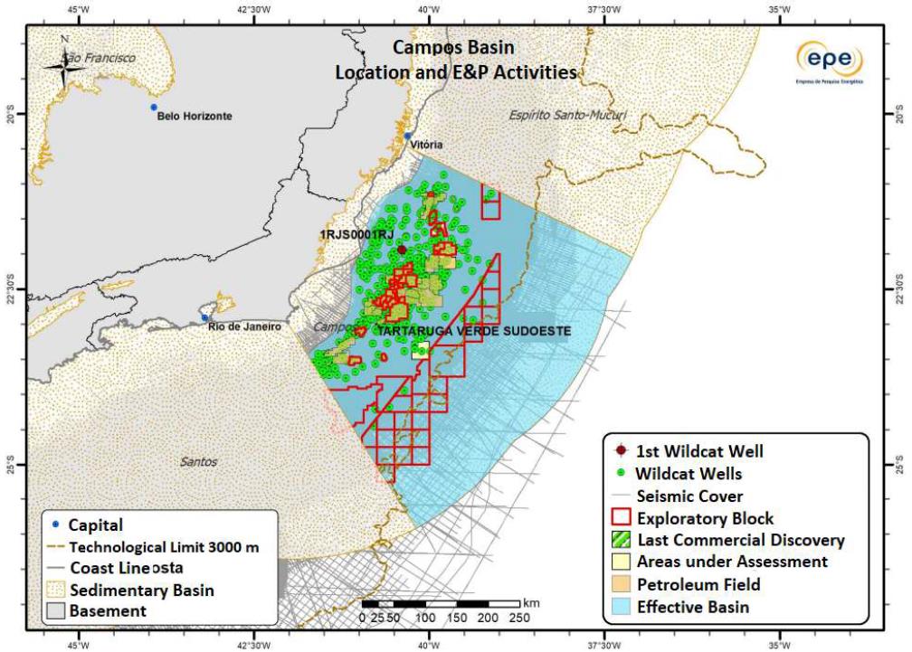
The Campos Basin locates in Brazil southeastern, between Rio de Janeiro and Espírito Santo states in a sedimentary area of approximately 173,331 km² (ANP, 2015; EPE, 2019 – Figure 1). The basin has an onshore and offshore area with its limits defined in the North with the Espírito Santo Basin, by the Vitória High, and in the South with the Santos Basin by the Cabo Frio High, in the West, in the onshore area, by the igneous and metamorphic rocks outcrops belonging to the Ribeira Belt that make up its Precambrian basement, and to the East by the sedimentation towards abyssal plain oceanic.
The Cenozoic sedimentary cover is represented by the Barreiras Formation (Miocene) and the quaternary coastal deposits near the mouths of rivers such as Paraíba do Sul River, however, as they are not of petrolific interest, these deposits will not be described in this paper.
Figure 1. Campos Basin location and exploratory activities information’s. Source: Modified and Translated from EPE (2019).
Tectonic-sedimentary evolution
The Campos Basin has its origin and evolution related to the opening process of the South Atlantic, during the Gondwana paleocontinent fragmentation (Final Jurassic/Early Cretaceous), and the tectonic efforts in the basin generation process resulted in the basic stages classically described as: Rift, Post-Rift (Transitional) and Drift (Marine). The first stratigraphic chart was prepared by Schaller (1973), later updated by Rangel et al. (1994), both focusing on lithostratigraphy. Winter et al. (2007) developed a stratigraphic chart emphasizing the depositional sequences, this being the most recent Campos Basin stratigraphic chart (Figure 2).
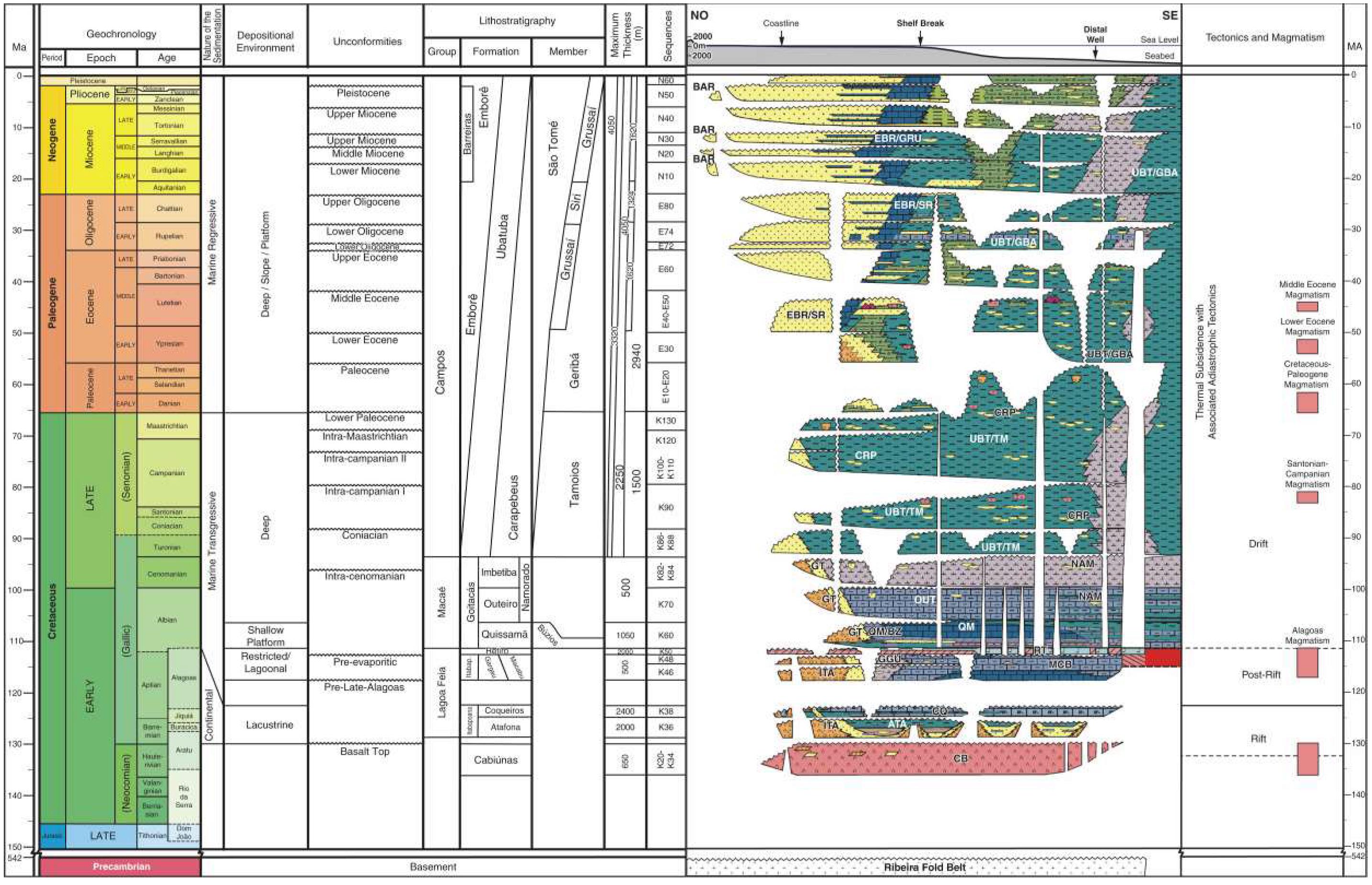
Figure 2. Stratigraphic Chart of the Campos Basin. Source: Winter et al. (2007).
The Rift section (Hauterivian/Aptian), according to the mega sequences described by Winter et al. (2007) is subdivided into Sequences K20-K34, K36 and K38, and correspond to the Lagoa Feia Group continental sediments, deposited on the Cabiúnas Formation basalts. They are conglomerates, sandstones, siltstone, reddish shales, and lacustrine carbonates. In the onshore area, are described basic rocks dikes with NE-SW direction, correlated with the Cabiúnas magmatism (ANP, 2015). No deposits from the Sin-Rift I phase are found in Campos Basin, which may not have been preserved, with the Sin-Rift II and Sin-Rift III phases present (Chang et al. 1992; ANP, 2015). The Sin-Rift II phase started from the crustal distension that resulted in a series of half-grabens with intense volcanism (Cabiúnas Formation - correlated to the Serra Geral igneous event in the Paraná Basin) and with lacustrine deposits associated (Sequences K20- K34). Sandstones, siltstone, and conglomerates associated with successive basaltic spills are identified, with some occurring fractured and with vesicles, as they occur in the reservoirs from Badejo Field (Winter et al., 2007; ANP, 2015).
In the Sin-Rift III phase (Sequences K36 and K38) there is a predominance of fluvio-deltaic, lacustrine and alluvial fan sedimentation, with the occurrence of clayey packages, deposited in a freshwater lake environment (Winter et al., 2007), sandstones, sin tectonic conglomerates and carbonate composed by shells of pelecypods (coquinas) in structural highs (Alto de Badejo, for example). A striking feature is thetalc-stevensite clay minerals, which, according to Dias (2005), were precipitated in alkaline volcanic lakes.
This mega sequence is represented by the Cabiúnas (volcanic), Atafona (siltstones and sandstones with talc-stevensite), Coqueiros (“coquinas” and shales) and Itabapoana (conglomerates) formations of the Lagoa Feia Group (Sequences K36 to K38 - Winter et al., 2007). The shales of the Atafona Formation are important source rocks - Buracica Shale, however, the shales of the Coqueiros Formation, are the main source of the basin - Jiquiá Shale. The “coquinas” (calcirrudites, calcarenites and bioclastic) of the Coqueiros Formation, are the main reservoirs in the Rift Sequence (Guardado et al., 1989).
The Post-Rift Phase, also called Transitional Evaporitic Mega Sequence (Sequences K46 and K48, and Sequence K50 - Winter et al. 2007), is separated from the Continental Mega Sequence by the Upper Pre-Aptian discordance (Dias, 2005), and refers to the Lagoa Feio Group upper portion, with deposition
during Aptian (local Alagoas Stage), between 118 and 112 M.y. (Guardado et al., 1989; Castro and Picolini, 2014; ANP, 2015). It is a transitional phase between thermal and mechanical subsidence and tectonic stabilization (sag), with continental and marine deposition (Guardado et al., 1989; Dias, 2005). This Mega
Sequence consists of the Itabapoana (conglomerates), Macabú (stromatolites and microbial laminites), Gargaú (marl and calcilutite) and Retiro (anhydrite, halite, carnallite and sylvinite) formations from Lagoa Feia Group (Mohriak et al., 2008; Castro and Picolini, 2014; ANP, 2015).
Continental deposition predominated in Eoalagoas, in alluvial, lacustrine, and fluvial fan systems. In Neoalagoas there is a transition between restricted and continental epicontinental sea environments. On the coast, the marine incursion into extensive shallow regions resulted in the concentration of hypersaline waters that led to the construction of microbials (ANP, 2015). At the end, evaporite deposition occurs in a restricted environment, with little water circulation, limited to the south by a volcanic chain of EW direction, called Dorsal de São Paulo (ANP, 2015). The K46 Sequence is composed of conglomerates and sandstones at the edge of Itapaboana Formation; and carbonates, marl, and sandstones from shallow transitional environment of the Gargaú and Macabu formations. In the distal microbial laminite portions and exposure features in Macabu Formation they are frequent in comparison with proximal portions, indicating the passage of the K46 to K48 sequence in an interval of 115 M.y. (Winter et al., 2007).
Representing K50 Sequence, Retiro Formation was deposited during the Lower Albian, being composed of chemical sediments that register an environment with association of lagoons and sabkha plains, in a period of about 112 M.y. between the beginning and the end of deposition. Variations in the mineralogy of the proximal, median, and distal areas are observed, occurring, respectively, anhydrite,anhydrite/halite and anhydrite/halite/carnallite/sylvite minerals (Mohriak et al., 2008). The halo kinesis developed in this sequence allowed to modify the Campos Basin structuring, creating favorable conduits and depocenters for the Upper Cretaceous turbidites deposition (Winter et al., 2007), between 118 and 112 M.y. (Guardado et al., 1989; Castro and Picolini, 2014; ANP, 2015).
The Drifte Phase (Albian to Recent) comprises marine sediments deposited in a regime of thermalsubsidence associated with adiastrophic tectonism (halokinesis). In this Super Sequence, sediments from shallow platform environments to deep seas are deposited in transgressive and regressive episodes, whereas in the Cenozoic, the trend was predominantly regressive (Winter et al., 2007). This phase constitutes the deposits of the Macaé and Campos groups (Ubatuba, Carapebus and Emborê formations), aged between Albian and Holocene (Winter et al., 2007). The Shallow Platform Carbonate Mega Sequence was deposited in an open marine environment in Albian, with alternating successions of highstand system tracts (HST) with high energy carbonate deposition (packstones/grainstones) and transgressive system tracts with low energy carbonate deposition (wackestones/mudstones), represented mainly by Quissamã Formation from Macaé Group (ANP, 2015).
In the Transgressive Marine Mega Sequence, there was a progressive sinking of the basin and the global rise in sea level, resulting in the drowning of the carbonate platform and consequent deposition of low-energy sediments such as shales, marl and calcilutites (Chang et al., 1992). This Mega Sequence comprises the formations Outeiro (calcilutitos and shales), Imbetiba (calcilutitos) and Namorado (sandstone) from Macaé Group, the Tamoios Member from Ubatuba Formation (shales) and Carapebus Formation (sandstones) (ANP, 2015a). The Regressive Marine Mega Sequence is composed in predominance by successive fluvio-deltaic sequences, with the occurrence of delta fans, siliciclastic platforms and turbidites in deeper waters. This Mega Sequence is represented by the Ubatuba (shale), Carapebus (sandstone) and Emborê (carbonate) formations (ANP, 2015).
Macaé Group has a concordant occurrence aboveRetiro Formation evaporites, consisting of the Goitacás, Quissamã, Imbetiba and Outeiro formations. Goitacás Formation represents the proximal environments characterized by the association of alluvial fans, fan deltas, lagoons, and beaches (Castro and Picolini, 2014). The Quissamã Formation records a carbonate system with low and high energy facies, with the proximal area characterized by siliciclastic-carbonate facies and the distal area with typically carbonate facies (Castro and Picolini, 2014). The main reservoirs are oolitic and oncolitic calcarenites, deposited in shallow water banks, related to carbonate and inter-bar systems. In the most distal portion, shales and marl occur (Castro and Picolini, 2014).
Exploration and production history in Brazil and in the Campos Basin
From the end of the 19th century to the middle of the 20th century, the exploration of Brazilian oil and gas was concentrated in terrestrial basins, with the first efforts in the Recôncavo Baiano and in the Paleozoic basins (Lucchesi, 1998; Morais, 2013; Mendonça, Spadini and Milani, 2003). Institutions were created seeking to organize these exploratory efforts such as the National Department of Mineral Production (DNPM - Portuguese Acronym) in 1933, and the National Petroleum Council (CNP - Portuguese Acronym) in April 1939. Commercial production started in 1941, and in 1963 there was a discovery from Carmópolis Field, main producer at the time in the Recôncavo Basin, reaching the peak of national production in the 1970s (Bacoccoli, 1986; Lucchesi, 1998; Mendonça, Spadini and Milani, 2003; Morais, 2013).
With the creation of Petróleo Brasileiro S. A. (Petrobras), in 1953, the Union began to exercise a monopoly on the exploration, production, refining and transportation of oil and oil products, organizing national exploratory research (Mendonça, Spadini and Milani, 2004; Morais, 2013). The excessive costs need for technology and logistical difficulties motivated the migration of the exploratory process from onshore basins to the Brazilian platform, under risk contracts, increasing investments in the acquisition of geological-geophysical data in shallow waters. As a result, a series of discoveries between the 70s and 80s on the Brazilian East Margin increased production to 500,000 bbl/day at the end of 1984 (Bacoccoli, 1986; Morais, 2013; ANP, 2015).
The Campos Basin was the protagonist with the discovery of the Garoupa field in 1974, in Albian carbonates by well 1-RJS-9A-RJ. Several fields were discovered in the shallow waters of the Campos Basin in different exploratory plays, such as the fields of Badejo in “coquinas” of the lower Aptiano (rift phase), Enchova in Eocene sandstones and the first giant field in Brazil that was the Namorado field discovered in Cenomanian turbidites (ANP, 2015). The seismic acquisitions in deep waters, in the 1980s, and the exploratory campaign that followed led to the discovery of giant fields in turbiditic plays, among them Albacora (Miocene) and Marlim (Oligo-Mioceno). Between the 80s and 90s, the development of 3D seismic, and the advance in the use of seismic attributes, led to the discovery of Barracuda giant field in Oligocene to Eocene turbiditic sandstones (ANP, 2015).
Despite the oil crisis between 1970 and 1980, Campos Basin maintained exploratory progress and the production of its fields, and between 1974 and 1983, 345 exploratory wells were drilled, and 22 oil fields were discovered. Between 1977 and 1985 the daily production in water depths between 90 and 383 meters increased from 160,800 barrels in 1977 to 546,300 barrels in 1985. During this period, Petrobras increased its investments in the basin, which increased from US $ 877 million, in 1970-1974, to US $ 5.4 billion, in 1980-1984, and the costs of exploration and production activities reflected 45% of the total amount invested by the Company between 1975 and 1979, and 84% between 1980-1989 (ANP, 2015; Bacoccoli, 1986; Lucchesi, 1998; Mendonça, Spadini and Milani, 2003; Morais, 2013).
Advancing to drilling in deep waters, 400 to 1,000 meters of water depth, the discoveries of Albacora (1984) and Marlim (1985) stand out. In the 90s, with exploration in water depths between 2000 and 3000 meters, discoveries were made in turbiditic sandstones such as the Marlim Sul (well 1-RJS-0460-RJ) and Roncador (well 1-RJS-0436A- RJ) in Maastrichtian sandstones with approximately 9 billion barrels of oil in place (ANP, 2015; Mendonça, Spadini and Milani 2004).
In 1997, the New Petroleum Law (Law 9,478/97) broke the Union's monopoly, allowing the entry of private operators, operating on a concession basis through bidding rounds conducted by the ANP (Mendonça, Spadini, Milani and 2004). This time, the petroleum exploration phase began in deep and ultradeep waters in the Campos Basin. Noteworthy are the accumulations of Maromba, Papa Terra, Peregrino, Xerelete and Parque das Conchas (Shell Park), as well as the discoveries of the Parque das Baleias (Whale Park), and the discovery of reservoirs in aptian pre-salt microbial carbonates previously to the Santos Basin pre-salt discoveries (ANP, 2015). The Figure 3 below summarizes the exploratory evolution of the Campos Basin, with the number of wells drilled and the main discoveries in shallow, deep and ultra-deep waters, according to the ANP Technical Seminar (ANP, 2018).
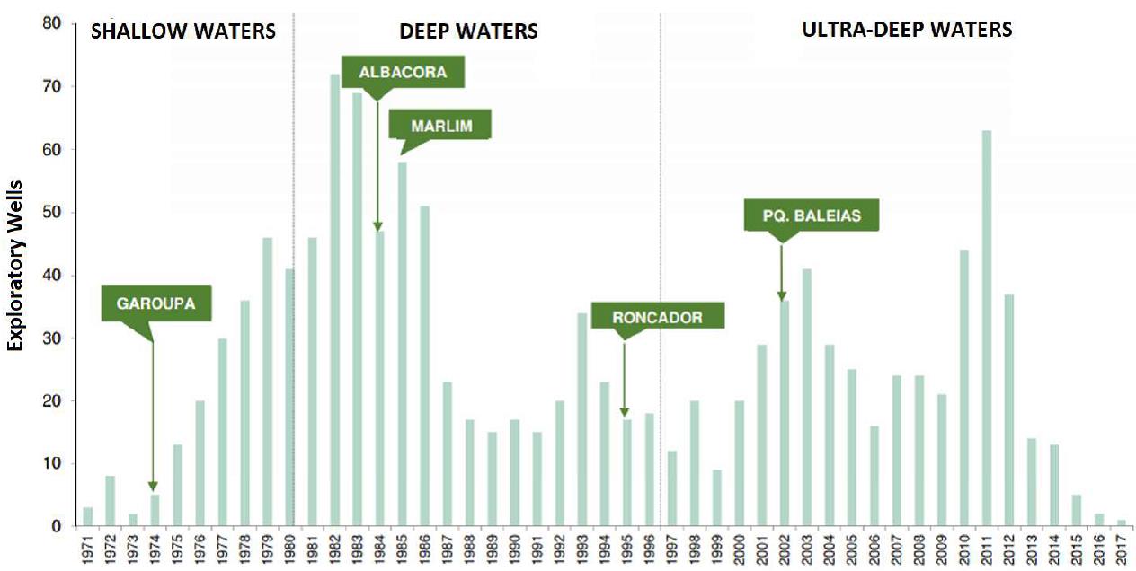
Figure 3. Campos Basin Exploratory History from 1971 to 2017. Source: Modified and Translated from ANP (2018).
Important challenges were overcome to allow exploration in deep and ultra-deep waters, such as unfavorable climatic and oceanographic conditions for the handling of offshore equipment, the hydrostatic pressures resulting from the water column, the low temperatures on the seabed, the conditions of the seabed, and more recently the difficulty in drilling the salt layer (Morais, 2013). Due to the distance between the platform and the well (up to 13,000 m), it was necessary to resize drilling columns, flow lines and risers that could withstand the great pressures imposed. Another challenge was the distance between the oil production or storage platforms to the coast (above 300 km). Additionally, the presence of impurities such as hydrogen sulfide and carbon dioxide in the reservoirs are still challenging in the exploratory process, as depending on their concentration they can cause corrosion in materials and equipment, such as Christmas tree, risers, putting the lives of workers at risk, and the change in oil viscosity can make extraction difficult, making the project unfeasible (Morais, 2013; D'Almeida et al., 2018).
The Campos Basin is the second main hydrocarbon producing basin in Brazil, responsible for national 28% oil production and 13% natural gas production (ANP, 2021; EPE, 2020a), being highlighted in the main ANP bidding rounds. Recently, during the 14th and 15th Bidding Rounds of the ANP, 19 exploratory blocks were offered under concession, 17 of which were auctioned (ANP, 2018). In the 3rd, 4th, and 5th Production Sharing Rounds of the 4 exploratory blocks offered, 3 were auctioned off. During the 16th Bidding Round (October 2019), 13 blocks were placed on offer in ultra-deep waters, 10 of which were auctioned (EPE, 2019).
Petroleum systems and exploratory plays
The main petroleum systems and plays are indicated in ANP geological summaries (ANP, 2015, 2017, 2018): Lagoa Feia-Carapebus (!), Lagoa Feia-Lagoa Feia (!), Lagoa Feia-Namorado (!) And Lagoa Feia - Quissamã (!). The 14th ANP Production Sharing Bidding Round and the 15th ANP Concession Bidding Round (ANP, 2017, 2018) also presented the petroleum systems: Lagoa Feia - Macabú (!), Lagoa Feia - Coqueiros (!), Macaé - Carapebus (!). Campos Basin is a High Potential Basin, with Lagoa Feia-Carapebus (!) being the main petroleum system, and the predominant exploratory status is Established (sensu EPE, 2019b), with only Play Siri indicated as Immature. It has a sedimentary area of 173,331 km² and the Effective Basin area of 159,513 km² (EPE, 2019) - Figure 4.
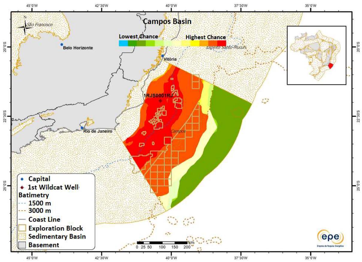
Figure 4. Map of the Probabilistic Effective Basin of Campos, indicating the chances of discoveries in the basin. Source:Modified and Translated from EPE (2019).
The turbiditic reservoirs of the Upper Cretaceous and Paleogene are responsible for most of the oil produced in the basin (ANP, 2017; EPE, 2019). Migration is predominant in salt windows, where listric faults take oil from the rift phase to different reservoirs in drift phase (post-salt). The main seals are shales, and the expected traps are structural, stratigraphic, and mixed, related to the distensive tectonics and halo kinesis (ANP, 2017; EPE, 2019). In the next item will be described the Campos Basin exploratory plays with their main elements and processes, in accordance with the ANP (2015, 2017, 2018) and EPE (2019) classifications. The source rocks are shown in the geological section in Figure 5.
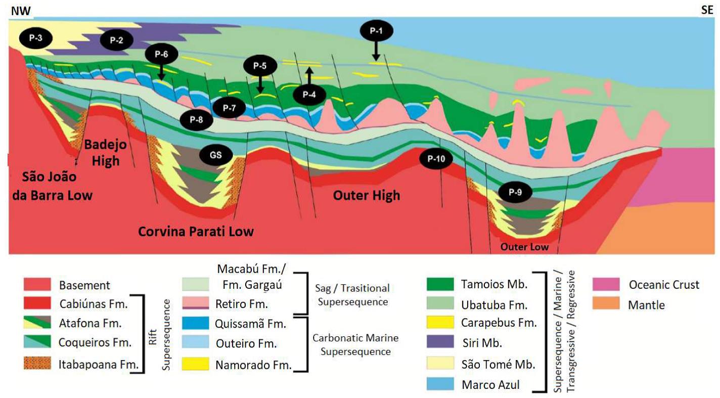
Figure 5. Campos Basin geological section with indication of the main petroleum system source rock (GS) and exploratory plays (P). Source: Adapted from ANP (2015) and EPE (2019b).
Data source:Campos basin: review on the geology and its oil and natural gas exploration and production context.
Latin American Journal of Energy Research – Lajer (2023) v. 10, n. 1, pp. 1–12. Aline de Jesus1, Pamela Cardoso Vilela
Следующий Бассейн: Santa Catarina Ultradeep