Тип бассейна:
Подтип бассейна:
Класс бассейна:
Возраст бассейна:
Тип полезных ископаемых:
Геологический возраст начало:
Геологический возраст конец:
Площадь: 1580436.9 км²
Congo Basin
This basin is located in the centre of the African Plate, covering most of the Democratic Republic of Congo (DRC, formerly Zaire), the People’s Republic of Congo and the Central African Republic (Veatch, 1935; Cahen, 1954; Lepersonne, 1977; Daly et al., 1992; Giresse, 2005).
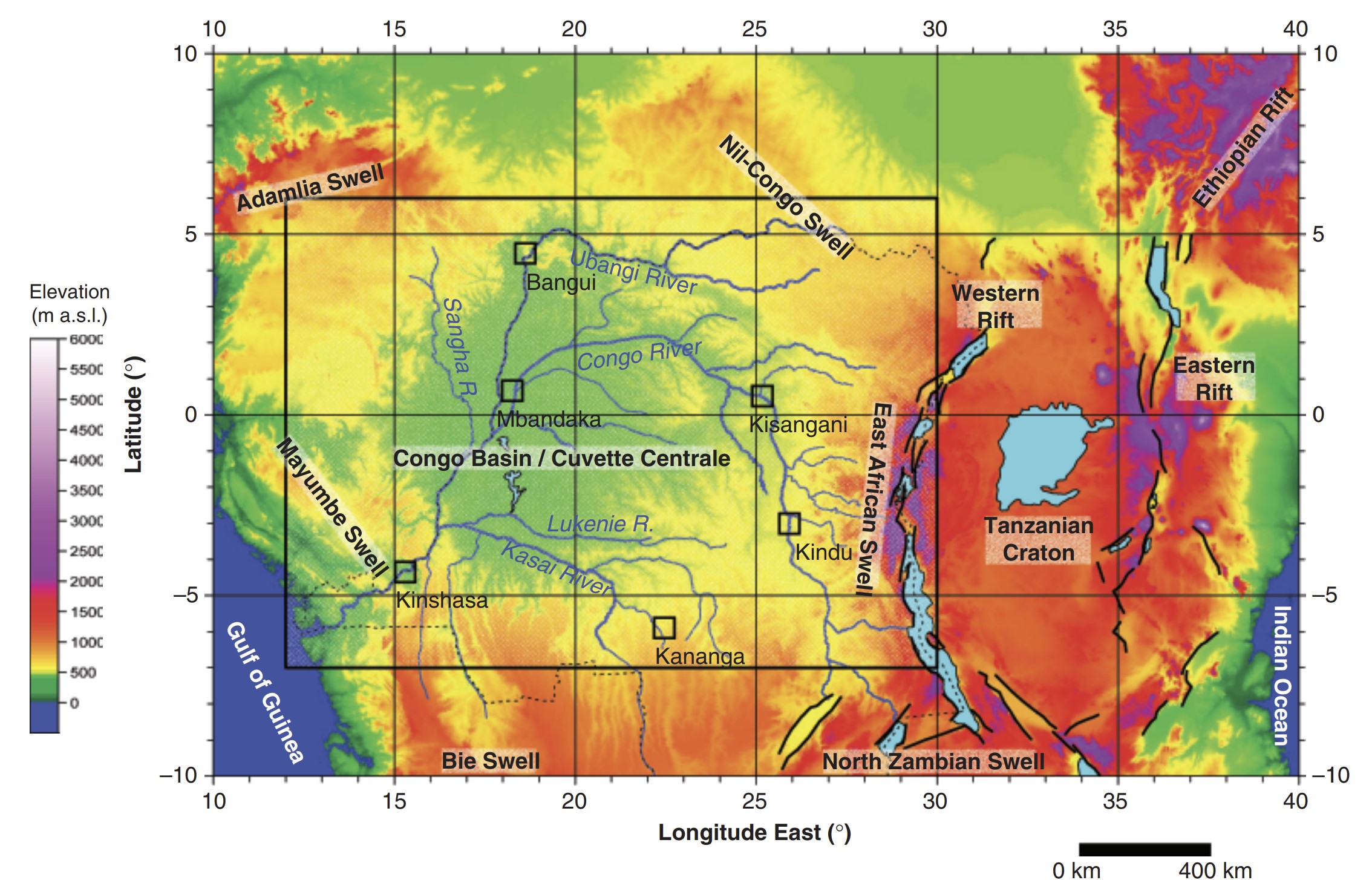
The major problem in depicting the geological history of this broad structure is that outcrops, wells and seismic lines provide a picture too scattered and with a poorly defined time frame to interpret the past geological history of this huge area as that of a single and coherent basin. Depending on the location and time of deposition, the Neo – Proterozoic- Early Phanerozoic sediments might be related to failed rift basin, foreland basins, or platform cover as in the Taoudeni basin over the West African Craton or the Riphean-Vendian over the Siberian Platform. Since the Late Carboniferous and up to the Triassic, they are mainly related to the Karoo period in the Gondwana continent, with glaciations, rifting and tectonic inversions (de Wit & Ransome, 1992; Burke et al., 2003; Catuneanu et al., 2005). During the Cretaceous and Cenozoic, a succession of continental deposits separated by peneplanation surfaces and totaling a maximum thickness of 1000 m emplaced in a slow subsidence process (Giresse, 2005). Since the Cenozoic, the basin acquired the form of an internal sag basin, from which the term ‘Cuvette Centrale’ has been derived by the first explorers. It defines the hydrographic basin of the Congo River and is surrounded by topographic highs interpreted as swells (Burke et al., 2003; Burke & Gunnell, 2008); successively the Adamlia, Nil-Congo, East African, North-Zambian, Bie and Mayombe swells (Fig. 1). Other sag basins also appeared during the same period more to the south (Kalahari and Okavango basins; Haddon & McCarthy, 2005). During the Miocene, broad flank uplift of the Atlantic rifted margin closed the basin, stimulating the formation of gorges and rapids across the Mayombe Mountains and maintaining the basin floor to a present day altitude of 290 m asl (Seranne & Anka, 2005).
Fig.1. Oro -hydrography of the Congo Basin in Central Africa. It forms a huge sub - circular depression encircled by relatively high relief zones and drained by the Congo River and his tributaries (Gtopo altimetric data color-coded in function of elevation). Location of the major cities are indicated. Rectangle shows the area covered by Fig. 2.
GEOLOGICAL SETTING
The Congo Basin covers about 1.2 106 km2 and is one of the largest intracratonic basins in the world. It is underlain by a thick (200 30 km) lithosphere and coincides with a region of pronounced long-wavelength gravity anomaly (Crosby et al., 2010). Cenozoic to Recent sediments occupy the center of the basin while the larger part of it contains Mesozoic sediments. The Paleozoic and Neoproterozoic sediments outcrop at the periphery of the basin and have been explored by drilling in the central part (Fig. 2). They overly a metamorphic to crystalline basement that was initially considered as forming a large cratonic mass: the Congo craton (Cahen, 1963, 1982). Continental- scale tomography however indicates no pronounced lithospheric keel under the central part of the basin, in contrast with thick lithosphere beneath the exposed Archean surrounding blocks (Pasyanos & Nyblade, 2007). The Congo craton is now considered as composed of several Archean nuclei (Angola-Kasai, NE Congo, Chailu/Gabon, Bangweulu) that are welded together as a result of Paleoproterozoic collision orogeny (De Waele et al., 2008; Kanda Nkula et al., 2009). The presence of tectonic dislocations a¡ecting the sediments of the Congo Basin (Daly et al., 1991, 1992; this paper) and its current seismic activity (Ayele, 2002; Delvaux & Barth, 2010) show that the crystalline basement does not behave fully as a rigid cratonic mass.
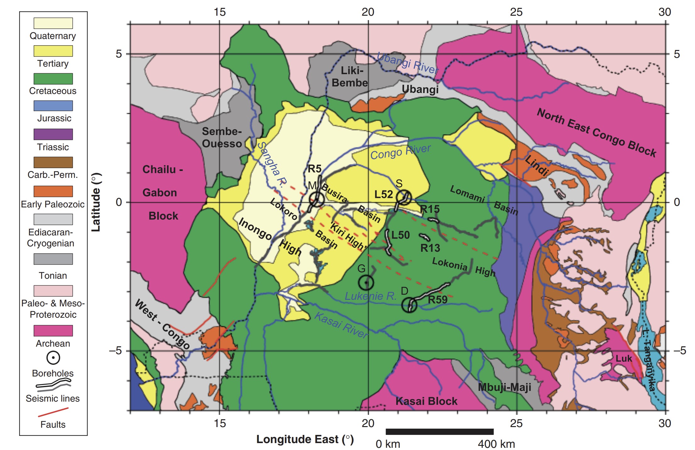
Fig. 2. Simpli¢ed geological map of the Congo Basin, compiled from various published map.The stratigraphic units have been assembled into major sequences (Late Neoproterozoic, Paleozoic and Cenozoic), corresponding respectively to seismic units A, B and C as de¢ned here from the seismic and well data. Bold labels de¢ne the Archean cratonic blocs, the stratigraphic Groups and the internal structural element of the Congo Basin. Deep faults interpreted from the seismic pro¢les are shown as dashed lines. Faults that have evidence for activity during the Paleozoic-Mesozoic are shown as continuous lines. Location of the 4 wells: (S: Samba ^TD at 2038 m, D: Dekese ^TD at 1826 m, M: Mbandaka ^TD at 4350 m, G: Gilson ^TD at 4536 m), and the seismic pro¢les acquired between 1970 and 1984 by Shell,Texaco and JNOC. Major morphotectonic provinces are indicated. Luk: Lukuga coal-bearing basin
The Congo basin appears to evolve in a succession of di¡erent geodynamic processes, rather than under a single process operating continuously over 800Ma. Initiation of the basin in the Neoproterozoic could be at least partly caused by intracratonic extension, and the subsequent long evolution is likely influenced by subsidence related to the cooling of stretched lithosphere, despite several periods of basin inversion. Seismic high shear-velocity structures that extend to 250 km depth have been noted beneath the Congo craton (Ritsema & van Heijst, 2000). The GRACE satellite free-air gravity field (Adam, 2002; Crosby et al., 2010) shows a spectacular long-wavelength low of 30 mGal over most of the Congo Basin and 40 mGal in its center, confirming the existence of a large low-density sedimentary infill, at least partly compensated by high-density material in the lower crust and/or upper mantle but which, according to Braitenberg & Ebbing (2009) cannot be explained fully by a crustal thinning mechanism and therefore as due to concealed rift basins. Considering the coincidence of the anomalous topo - graphic depression of the Congo Basin with this large negative free-air gravity anomaly and a large positive uppermantle shear-wave velocity anomaly, Downey & Gurnis (2009) explain this huge Cenozoic depression by the action of a downward dynamic force on the lithosphere that they relate to a high-density object within the lithosphere. Others relate the observed present-day gravity anomaly to a late phase of basin subsidence in response to a downwelling mantle plume (Hartley & Allen, 1994; Forte et al., 2010). Both Downey & Gurnis (2009) and Crosby et al. (2010) place the source of the gravity anomaly below the base of the lithosphere, the ¢rst suggesting the anomalous mass could be made of eclogite, the second that it could be generated by a convective drawdown caused by chemical density depletion of the lithospheric mantle and related to the African Superswell of Nyblade & Robinson (1994). Recently, Kadima et al. (2010, 2011) mapped a NW^SE elongated positive and narrow residual gravity anomaly related to a post-rift event before basin subsidence, aligned with the Sembe-Ouesso and the Mbuji-Maji rift sequences that outcrop respectively to the NW and the SE of the Congo basin.This supports the Neoproterozoic rift origin of the basin as earlier postulated by Daly et al. (1992).
STRATIGRAPHIC EVOLUTION
As the Congo Basin lies for its larger part within the DRC, the knowledge of its stratigraphy also depended on the progressive geological exploration conducted in this country. Before the ¢rst subsurface exploration period with the geophysical acquisitions and drillings, its stratigraphy was inferred from the succession of formations outcropping at its periphery, assuming that they were continuous over large distances (Veatch,1935; Cahen,1954; Cahen & Lepersonne, 1954). The sedimentary succession of the area was ¢rst recognized by two stratigraphic wells (Samba and Dekese wells) drilled in 1955 and 1956 by REMINA that terminated in red arkoses of Late Neoprotero - zoic to Early Paleozoic age.The litho - stratigraphic scale of Cahen et al. (1959, 1960) was later re¢ned by Lepersonne (1974a, 1974b, 1977), taking into account the results of various studies on the Samba and Dekese drill holes and outcrop data.
Two exploration wells (Mbandaka and Gilson) were later drilled in 1981 by ESSO Zaire, and bottomed in the Neoproterozoic (ESSO Za|«re SARL, 1981a, 1981b). Combining surface geology with well information, Daly et al. (1992) presented a single composite stratigraphic column in order to illustrate their views of the tectono - stratigraphic evolution of the basin. This column is however too generalized to be useful here as it interpolates various stratigraphic units which are discontinuously observed within the c. 1200 km wide Congo Basin and which are loosely correlated. In addition, time control is largely lacking for the pre-Karoo deposits and some units have restricted lateral extension, lateral facies change or may be missing in place.
An updated stratigraphy of the Congo Basin is presented hereafter, integrating the knowledge gained from the 4 wells and presenting possible correlations with outcrop data (Fig. 3a and b). As limited seismic and well data are available for understanding the stratigraphic and tectonic evolution of the deeper part of the Congo Basin, a large part of the knowledge of the Neoproterozoic and Phanerozoic has been gained from the study of outcrop - ping units. The Late Paleozoic to Recent sediments are better represented in the wells and paleontologically dated, making the correlations with the outcrops more secure.
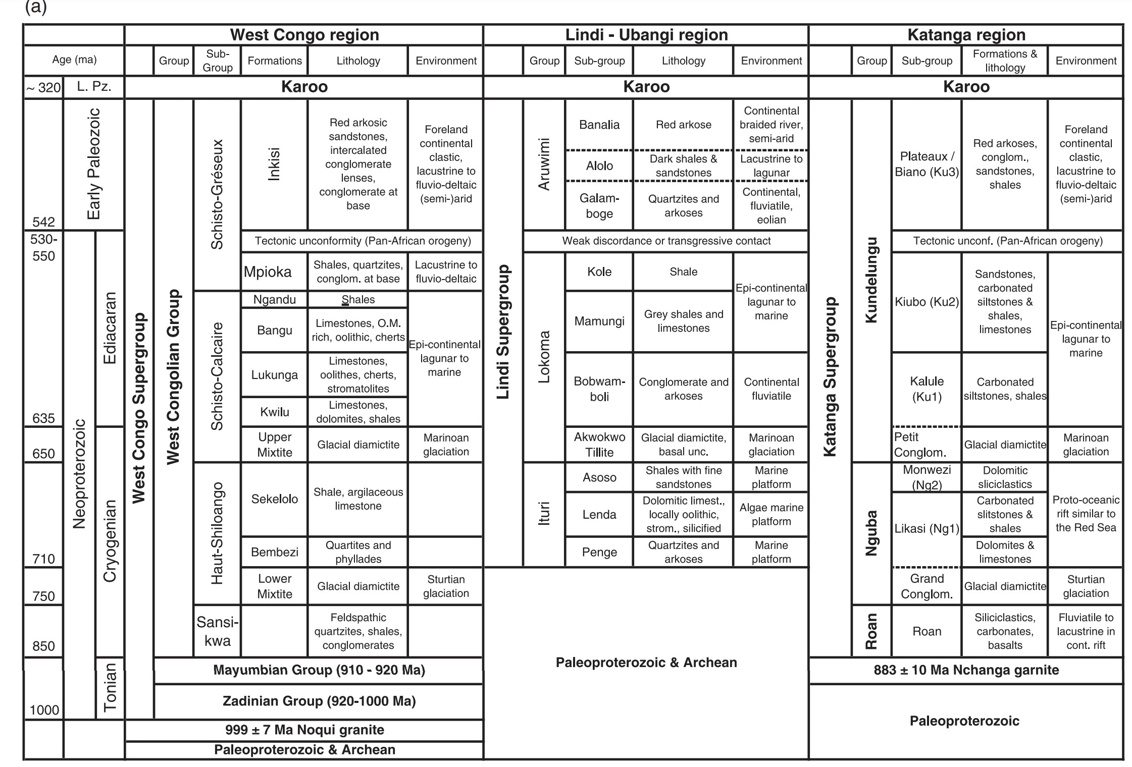

Fig. 3. Schematic lithostratigraphy of the Congo Basin (modified from Kadima et al. 2011a), based on the two stratigraphic wells (Samba and Dekese) and outcrop data in in the northeastern and eastern margins of the basin
TECTONIC DEFORMATIONS
The succession of deformation observed on the seismic lines led Lawrence & Makazu (1988) and Daly et al. (1991, 1992) to postulate that the initial basin subsidence was initiated by a Late Proterozoic failed rift and subsequent thermal relaxation. This rifting phase could be the consequence of the Rodinia breakup, which subdivided the Congo craton along NW^SE and NE^SW fractures (Ho¡man, 1999). As postulated by the same authors, the compressional inversions could be related to the far- ¢eld e¡ects of two tectonic events causing the assembly of the Gondwana continent: the Early Paleozoic Pan-African event (Kennedy, 1964; Krner et al., 2001), and the Permo -Triassic Gondwanide Andean margin type oblique converging event at the southern margin of Gondwana (Daly et al., 1991; Visser & Praekelt, 1996; Delvaux, 2001a; Newton et al., 2006).
Pan-African early rifting stage
In the Congo Basin, a poorly de¢ned early rifting stage is suggested by Lawrence & Makazu (1988) and Daly et al. (1991, 1992) to have controlled the deposition of the 210 m thick carbonate- evaporite sequence, before the deposition of the 700 m thick clastic sequence of the Schisto -Calcaire Subgroup.
A network of Late Neoproterozoic intracratonic tectonic depressions developing within the Congo craton have been proposed to control the Neoproterozoic carbonate sedimentation in Central Africa (Alvarez, 1995). The NE-trending Sangha aulacogen which presently controls the lower course of the Congo river between Mbandaka and the Atlantic ocean could be a dominant extensional structure, linking three belts of NW-trending basins, one centered on the outcropping region of the Lindian north of Kisangani, one centered on the Upper Sangha river in the People’s Republic of Congo, the Lukenie river and connected to the Mbuji-Maji and Roan basins, and one corresponding to the West-Congo belt (Fig. 3c).They might not be all contemporaneous, but they are believed to control the depositional histories in the early stage of development of the future Congo Basin. These basins apparently developed as failed rifts (aulacogens) between the Archean blocks of the Congo craton, without reaching the full oceanic stage.They could have been connected to the large rift system that possibly separated the Congo craton from the Kalahari craton, leading to the formation of a passive continental margin on the southern side of the Congo craton (Porada, 1989; Porada & Berhorst, 2000; Burke et al., 2003; John et al., 2004). In the region of the future Lu¢lian Arc, the WNW-trending Roan rift basin created the adequate environment for the deposition of the evaporate-rich carbonates (Porada & Berhorst, 2000; Jackson et al., 2003). These have been later involved in salt tectonics during the Lu¢lian orogeny as proposed by John et al. (2004). Similarly, the West-Congolian basin, and possibly also the Mbuji-Maji basin also created favorable conditions for carbonate shelf development and evaporate deposition as reviewed above.

Fig. 3. Continued
The gravity modelling and subsidence analysis of Kadima et al. (2010, 2011) further suggest the presence of a large fossil rift concealed under the central part of the Congo Basin and aligned in a NW^SE direction with the Sembe-Ouesso and the Mbuji-Maji failed rift basins (Fig. 3c).This Pan-African rifting stage, not only governed the sedimentation but also created permanently weak zones within the Congo craton, probably by reactivating the fabric of the Eburnean belts that sealed the cratonic cores. This is supported by the significant seismicity recorded within the Congo Basin (international catalogues and Ayele, 2002).
Pan-African near-field collisional stage
The Pan-African cycle terminates with the final amalgamation of continental blocs into the Gondwana continent (Collins & Pisarevsky, 2005; Tohver et al., 2006). This occurred with a series of collisional events that affected different parts of the continent. In Central Africa, the Pan-African deformations surrounding the Congo Craton and affecting the Neoproterozoic deposits of the Congo Basin are known mainly in the southeastern (Katanga) and western (Bas Congo) regions of the Democratic Republic of Congo:
in the Copperbelt of Katanga and Northern Zambia, the Pan-African event is responsible for the Lufilian Arc which is located approximately1000 km away from the center of the Cuvette. It is characterized by a compressional regime inducing curved folds, thrusted terranes and shear zones, with its paroxysm at 550Ma (Cailteux & Kampunzu, 1995; Porada & Berhorst, 2000; Batumike et al., 2006).
in the Bas Congo, the Pan-African event is also responsible for the West Congo belt (Fig. 2), which parallels the Atlantic coast between Gabon and Angola, and is located 200-400 km west of the Congo Basin. The intensity of folding and thrusting within the West Congo belt decreases from west to east (Boudzoumou & Trompette, 1988; Tack et al., 2001; Pedrosa-Soares et al., 2008).
To the NE and SE of the Cuvette, outcropping Neoproterozoic to early Paleozoic sediments are respectively known as the Lindi and Mbuji-Maji Supergroups (Fig. 3c). The first is weakly folded with few synclines or anticlines bounded by high-angle faults whereas the second forms a gentle NW^SE trending syncline affected toward the southeast by Pan-African NNE-SSW-oriented folds (Cahen et al., 1984).
The lower age limit for the paroxysm of the Pan-African orogeny surrounding the Congo Craton is at c. 550Ma, with the ¢nal collision at 530Ma with later manifestations atc. 520Ma., at the vicinity of the 542Ma Neoproterozoic^Cambrian transition (Porada & Berhorst, 2000; John et al., 2004; Armstrong et al., 2005; Rainaud et al., 2005).
Gondwanide far-field active margin stage
Some of the compressional structures observed on the seismic profiles have been attributed by Daly et al. (1991) to the Late Paleozoic - Early Mesozoic deformation. Within the Lindi Supergroup near Kisangani, Sluys (1945) and Verbeek (1970) describe a narrow WN-ESE belt of intense deformation involving folding, brittle shearing and metasomatism that affect the whole Lindi Supergroup (including the Aruwimi Redbeds) but which pre-dates the Upper Jurassic and Cretaceous sediments. In the Lukuga coal field near Kalemie along the Congolese side of Lake Tanganyika, Cahen and Lepersonne (1978) describe an unconformity between the Permian sediments of the Lukuga Group and the overlying Triassic sediments of the Haute Lueki Group, thus constraining the age during the Permo -Triassic transition. Further to the northeast, strikeslip deformations due to NNE^SSW to N^S tectonic compression and affecting the Permian coal-bearing Karoo rocks have been noted in the Ubende belt in Tanzania, particularly in the Namwele-Mkolomo coal field (Delvaux et al., 1998; Delvaux, 2001b).
These localized deformations scattered over a wide territory are coeval with the Late Permian-Early Triassic development of the Cape Fold Belt of South Africa (Hlbich et al.,1983; Le Roux,1995; Newton et al., 2006; Tankard et al., 2009). This belt was part of the Gondwanide passive margin orogen that framed the southern margin of Gondwana and was related to the Paleo -Pacific subduction plate dip - ping beneath Gondwana during Late Carboniferous to mid-Triassic times (Ziegler, 1993; Visser & Praekelt, 1996; Trouw & De Wit, 1999; Delvaux, 2001a; Giresse, 2005). The contractional deformations identi¢ed in the seismic sections of the Congo Basin are also related to the far- field deformation resulting from the distant (roughly 2500 km away) Cape folding event (Daly et al., 1991, 1992). At the same time, an extensional tectonic regime prevailed along the Tethyan northern margin of Gondwana (W˛pfner, 1994; Ring, 1995; Delvaux, 2001a; Catuneanu et al., 2005).
Source: Structure and geological history of the Congo Basin: an integrated interpretation of gravity, magnetic and reflection seismic data. E. Kadima, D. Delvaux, S. N. Sebagenzi, L. Tackw and S. M. Kabeya. Basin Research (2011) 23, 499–527
Следующий Бассейн: Angola Interior