Тип бассейна: Платформ
Подтип бассейна: Пассивных окраин (перикратонно-океанический)
Класс бассейна: Периокеанический
Возраст бассейна: Зрелый - Мезозойский
Тип полезных ископаемых:
Геологический возраст начало:
Геологический возраст конец:
Площадь: 125012.66 км²
The Gabon Coastal Basin
The Gabon Coastal Basin lies within the passive continental margin of West Africa between north latitude 1° and south latitude 4°, bounded to the east by basement and to the west by the 200 m isobath in the Atlantic Ocean. The total basin area is about 128 376 km2 (Lin et al., 2010; Liu J P et al., 2008; Guan and Li, 2007; Xiong et al., 2005; Tong and Guan, 2002).
Since the first discovery of hydrocarbon in 1951, a number of other significant oil fields such as the Anguille marine oil field, the Rabi-Kounga onshore oil & gas field, and the Olowi marine gas field have been discovered. The Gabon Coastal Basin is a typical saliferous basin similar to passive continental margin basins in the Persian Gulf, gulf of Mexico, North Sea, the coast of the Caspian Sea and elsewhere around the South Atlantic where salt tectonics are important for hydrocarbon accumulation. The salt formations and their overlying strata have become deformed by the buoyancy of salt, differences in load, gravity, thermal convection, compression and extension to form complex salt tectonic structures. Salt diapirism and its related fractures provide channels and a driving force for hydrocarbon migration, and abundant traps and caps for hydrocarbon accumulation (Liu Y L et al., 2008; Brink, 1974). The irregular shape and density inhomogeneity of Aptian evaporites combined with the plastic rheology of halite lead to poor quality seismic imaging of subsalt formations due to shielding and interference effects (Hudec and Jackson, 2007; Tang et al., 2005; Fort et al., 2004; Jia et al., 2003; Jackson et al., 2000; Jackson and Roberts, 1993; Nalpas and Brun, 1993; Jackson and Talbot, 1991), which restricts accurate interpretations of sedimentary sequences and structural features, and thus full understanding of basin evolution.
There has been a boom in oil and gas exploration in passive continental margin basins on both sides of the South Atlantic in recent years, leadin to extensive seismic exploration and drilling, and research results have begun to be published (He et al., 2011; Liu et al., 2011; Ma Z Z et al., 2011; Sun et al., 2010; Li and Guo, 2008; Ma J et al., 2009; Dupr et al., 2007; Dickson et al., 2003; Moungueneui et al., 2002; Robert and Yapaudjian, 1990; Teisserenc and Villemin, 1989).
These studies describe salt tectonics in basins include including the Gabon Coastal Basin, dividing them into extension zones and compression zones but this is an over-simplification of complex salt tectonics and evolution over different periods and in different tectonic units (Liu and Li, 2011; Ding et al., 2009; Liro and Coen, 1995). Published field observations, drilling, three-dimensional seismic interpretations, balanced cross-section constructions, physical modeling, numerical simulations and so on have established a variety of evolutionary models of salt tectonics for studying plastic rheological behavior of salt and salt tectonics. From among them evolutionary models involving stretching and shortening tectonics explain the salt tectonic evolution of the Gabon Coastal Basin well. This article analyzes the basin’s structural characteristics, salt structural styles and sedimentary facies by using seismic reflection profiles and drill logging data to establish a salt tectonic evolutionary model, distinguish tectonic evolutionary phases, establish the main deformation time and deformation range, and reveal the sedimentary filling processes and basin tectonic evolution.
GEOLOGICAL STRUCTURES
The Gabon Coastal Basin has double-layered basement architecture floored by a Precambrian crystalline basement and a Pre-Cretaceous folded basement. Post-Cretaceous sedimentary cover is mainly composed of sedimentary strata reaching a maximum deposition thickness of about 15 000 m of which the Cretaceous sedimentary thickness is 6 000–10 000 m.
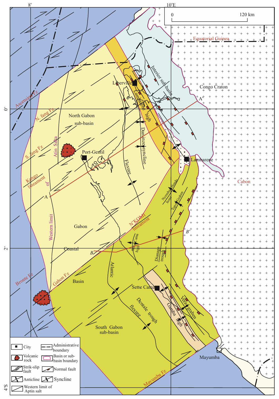
There are two sets of near-vertical fault systems of with NNW-SSE strike and NE-SW strike which give the basin an E-W directed zoned tectonic framework containing N-S directed blocks. The basin may be divided into four sub-units: Interior sub-basin, South Gabon sub-basin, North Gabon sub-basin and Lambarene high (Fig. 2).
Figure 2. Fault systems and tectonic units division of the Gabon Coastal Basin. Fz. Fault.
The NNW-SSE trending faults constitute the major fault system in the basin, associated with plate rifting and structural trends in the basin are basically consistent with strikes of these faults. The tectonic zonation in the basin is controlled by three tectonic hinge zones formed by these fault systems from east to west. (1) Hinge belt I formed at the end of the Late Jurassic resulting in the Septem-Kama sag, the Vembo Graben and the Interior sub-basin (Fig. 2) by downward faulting at the eastern boundary and overlapping at the western boundary, which controlled deposition in the Neocomian. (2) Hinge belt II developed in the Aptian resulting in the northern Lambarene high and the southern Gamba horst (Fig. 2), and the basin extended farther westward controlled by the fault which laid the foundation of characteristic east to west zonation. (3) Hinge belt III (also known as the Atlantic Hinge zone) developed from Late Cretaceous to Paleocene, the passive continental margin basin stage (Fig. 2), and was related to a discordogenic fault as a structural high caused by differential settlement of basement of the Gabon Coastal Basin. The east side of the belt is characterized by shallow-water platform deposits, the west side by deep-water shelf deposits.
The NE-SW trending fault system belongs is a set of transform faults (Fig. 2). Some of the larger fault zones such as the northern Fang fracture zone which forms the northern boundary fault of the Gabon Coastal Basin, the middle Enkomi fracture zone that forms the boundary of the North Gabon sub-basin and the South Gabon sub-basin, and the Mayumba fracture zone that forms southern boundary of the Gabon Coastal Basin, extend into the oceanic crust to join transform faults that offset the South Atlantic ridge. These large transform faults divide the basin into blocks from north to south.
Data source:Salt Tectonics and Basin Evolution in, the Gabon Coastal Basin, West Africa. Anqing Chen, Chong Jin, Zhanghua Lou, Hongde Chen, Shenglin Xu, Keke Huang, Sihan Hu.Journal of Earth Science, Vol. 24, No. 6, p. 903–917, December 2013
Следующий Бассейн: Doukkala Ultradeep