Тип бассейна: Платформ
Подтип бассейна: Внутриплатформенный (интракратонный)
Класс бассейна: Рифтовый (Внутриплатформенный)
Возраст бассейна: Молодой - Кайнозойский
Тип полезных ископаемых:
Геологический возраст начало: PG
Геологический возраст конец: N
Площадь: 28552.25 км²
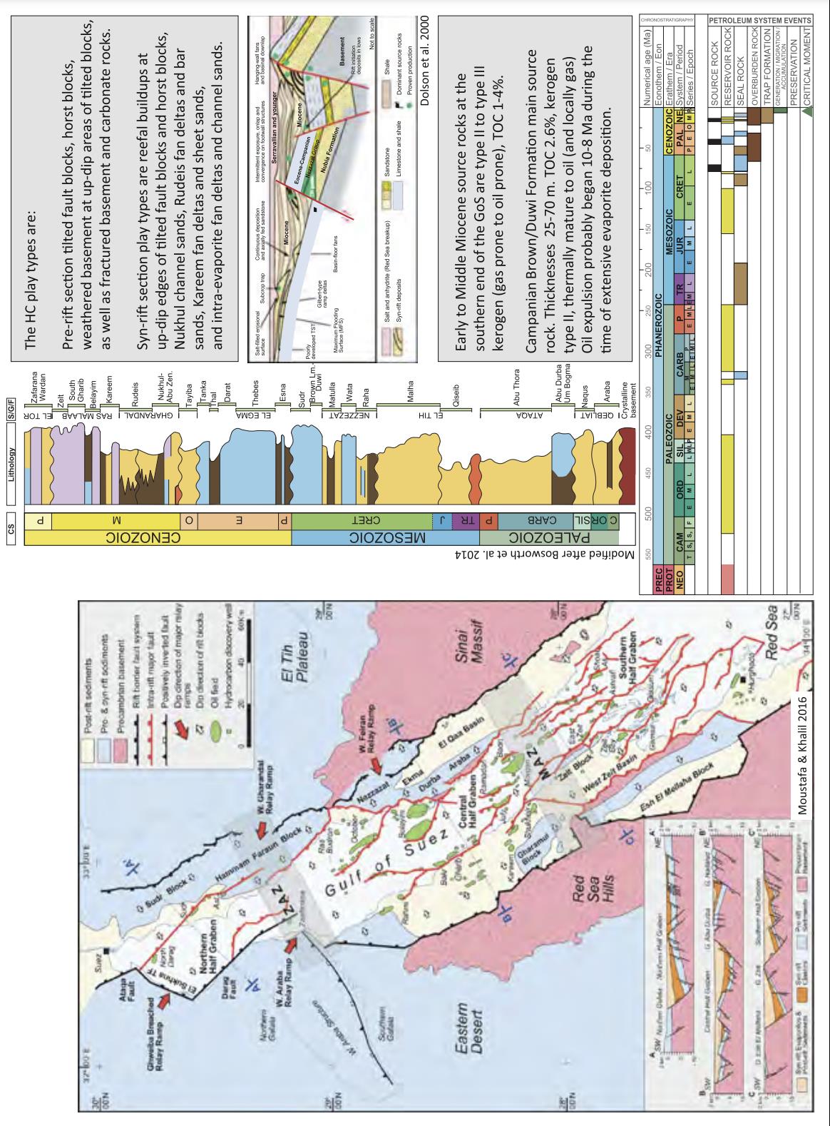
Gulf of Suez Petroleum System
The Gulf of Suez Basin began its life about 23 Ma as a northern segment of the Red Sea rift, with similar structural timing and syn-rift stratigraphy (Tewfik and Ayyad 1984: Miller and Baraket 1988). The basin is about 325 km long and 90 km wide at the junction with the Red Sea, decreasing to about 50 km wide at the latitude of Suez City (Fig. 1). The basin covers an area of about 24,000 km2 and contains approximately 11.5 BBO of proven reserves (Dolson et al. 2014). The average discovered oil per square kilometer is, therefore, ˜480,000 barrels, or more than twice the richness of the much larger Sirt Basin.
Fig. 1 Gulf of Suez petroleum systems, Egypt
The Gulf of Suez is comprised of three subbasins, each constituting a “mega-half-graben” that is internally broken into numerous, nested fault blocks (Fig. 1; Moustafa 1976; Angelier 1985; Bosworth 1985; Moretti and Colletta 1987; Colletta et al. 1988; Perry and Schamel 1990; Patton et al. 1994). Structural complexity increases toward the south and correspondingly the size of individual traps becomes smaller. The five largest fields—Morgan, Belayim, July, Ramadan and October—contain nearly 50% of the basin’s total reserves and are all located in the central part of the Gulf. These and many other Gulf of Suez fields are characterized by good reservoir parameters, tall oil columns, high reserves per unit of surface area, good oil quality and shallow-water depths. The producing fields are predominantly rotated fault blocks, or combination structural-stratigraphic traps. About 60% of discovered reserves are held in Miocene strata deposited during rifting, and 90% of these are siliciclastics (Egyptian General Petroleum Corporation 1996). For the 40% of the oil found in pre-rift strata, only about 5% comes from carbonates. Superb top and lateral seals are provided by Early Miocene shales of the Rudeis and Kareem Formations and by thick evaporites of the Middle to Late Miocene Belayim and South Gharib Formations (Fig. 1; Evans 1988; Richardson and Arthur 1988; Patton et al. 1994; Tawadros 2001; Bosworth and McClay 2001).
Three source rock intervals are well-documented in the Gulf of Suez, and there are probably several other units contributing locally. All are marine strata, dominated by type II kerogen, but with significant differences. The richest interval is the Campanian black shale, often phosphatic, referred to the Sudr or Duwi Formation or more commonly by industry simply as the Brown Limestone (El Ayouty 1990; Alsharhan 2003). Lindquist (1998) referred to oils derived from this source rock as the Sudr-Nubia (!) total petroleum system. “Nubia” is a collective name used by Lindquist and many other authors for pre-Red Sea rifting, predominantly continental sandstones ranging in age from the Cambrian to the Early Cretaceous. It is an unfortunate name for this petroleum system because the Nubia reservoirs are actually less important volumetrically than the younger syn-rift reservoirs. The second major source rock was deposited within the rift basin during the Early to Middle Miocene main phase of extensionally driven subsidence and lies principally within the Rudeis Formation in Egypt and the Maqna Group in Saudi Arabia. Lindquist (1998) called this the Maqna (!) total petroleum system as the principal reservoir rocks are part of the same formations. The Maqna/Rudeis reservoirs are largely marine siliciclastics, and because they were syn-tectonic in origin their lateral and vertical facies distributions are extremely complex (Richardson and Arthur 1988; Patton et al. 1994; Plaziat et al. 1998; Bosworth et al. 1998; Pivnik et al. 2003). The Maqna (!) source rocks have stronger terrigenous input than the Sudr-Nubia (!), and hence a mixture of type II and III kerogens prevails.
The thickness of the Brown Limestone varies from about 25–70 m. The organic-rich facies are absent in the northern Gulf of Suez sub-basin and in the Red Sea it is present only in the very north. TOC is typically 1.7–3.5% (Alsharhan 2003) but values over 20% have been measured in Egyptian phosphate mines along the northern Red Sea margin. Thermal maturity (top of the oil window) is reached at about 2400 m along the axis of the central Gulf of Suez but not until up to 3900 m in cooler basin margin settings (Alsharhan and Salah 1995). The timing of hydrocarbon maturation and expulsion varies for each sub-region but generally commenced about 10 Ma and continues to the present-day (Mohamed et al. 2013). The Rudeis source rocks often reach several 100 m in thickness but their richness is much lower and typically 1.5–2.2% TOC (Alsharhan 2003). Due to their higher position in the stratigraphic section, the syn-rift source rocks did not typically reach maturity until about 4 Ma.
The third commonly cited Gulf of Suez source rock is the Eocene Thebes Formation with TOC generally 1.4–1.7% (Alsharhan 2003). In the northern and central Gulf of Suez, the Thebes is 250–300 m thick, but it decreases to zero on fault block crests in the southern Gulf due to erosion during the onset of rifting (Bosworth and McClay 2001). Synthesizing the distribution of the three principal documented source rocks shows that they are all only present in the central sub-basin, fortuitously where the largest structures are also available to be charged.
Data source: Regional Geology and Petroleum Systems of the Main Reservoirs and Source Rocks of North Africa and the Middle East. D. Lučić and W. Bosworth. 2019
Следующий Бассейн: Jiza - Qamar