Тип бассейна:
Подтип бассейна:
Класс бассейна:
Возраст бассейна:
Тип полезных ископаемых:
Геологический возраст начало:
Геологический возраст конец:
Площадь: 496520.6 км²
Indus Basin
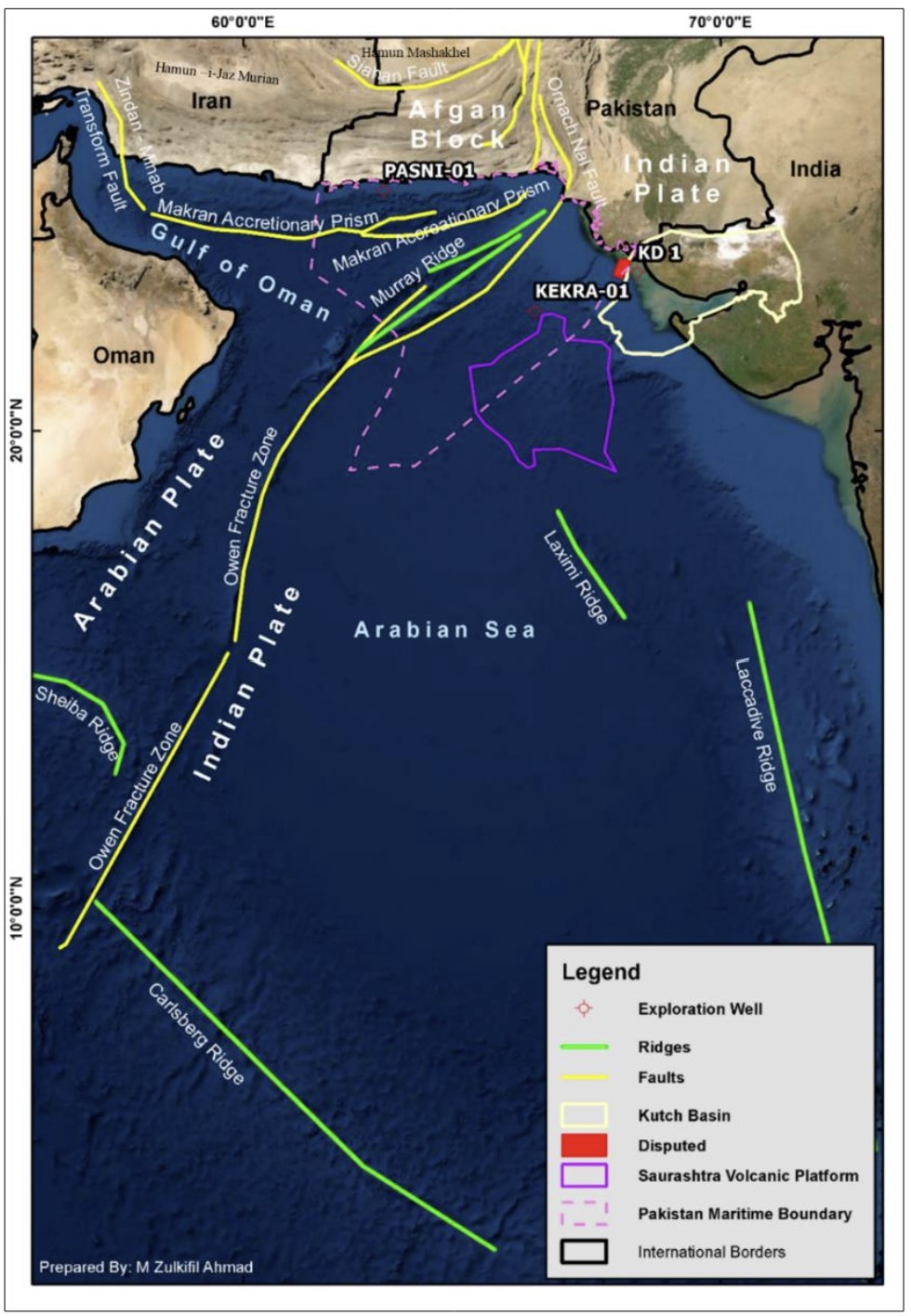
Pakistan contains three major sedimentary basins as Indus Basin, Makran Island Arc Complex and Pishin Basin. Three basins were evolved with different geological evolution, extending from land to Arabian Sea Shelf with spectacular mountains, plains, deserts and rivers system on land and offshore part in Arabian sea. NE-SW-trending right-lateral strike-slip fault of Murray Ridge in Arabian Sea divides Makran Offshore in the west and the Indus Offshore in the east; extended in north as left-lateral Bela-Ornach-Chaman transform fault system in the onshore dividing Makran Arc System and Pishin Basin from Indus Basin in west. Indus Basin occupied major area of overall basins of Pakistan with western plate boundary of Indian Plate along Murray Ridge in offshore and along left-lateral Bela-Ornach- Chaman transform fault system in the onshore (Fig.1).
Figure-1. Satellite imagery showing the regional structural elements of Arabian Sea. The Saurashtara volcanic platform outline (Corfield, 2010 et al., Kutch Basin outline (Isaac, J., 2017))
The tectonic events of Indus Basin initiated with the intra-cratonic rifting of Gondwana Super Continent in Late Protozoic followed by Permian- Triassic rift event. As a result, the Neo-Tethys Ocean was formed as an oceanic embayment between Laurasia to the north and Gondwana to the south; and opened by drifting of micro blocks rifted from the northern margin of Gondwana in the Early Permian. Afghan Block was one of micro block which was drifted from northern margin of Gondwana Block. Closure of the Neo Tethys Ocean and subsequent collision of India with Asia produced the Himalayan Mountain chain, Katawaz Basin (Pishin Basin) in North-western part of Indo Pak Plate and associated with Makran Subduction Zone. The rifting remains continues in Jurassic.
The last phase of Mesozoic rifting and sag resulted in the separation of Indian Plate from Africa and Madagascar cratonic elements.
During the time of Early Paleocene, Indian Plate passed over the Indian plate passed over the Reunion mantle hotspot and separation of the Seychelles occurred in Episode-6 (Ahmed et al., 2018). Largest volcanic activity was associated with Episode-6 in the form of Basaltic Flow of Deccan Trap in South India. Such volcanic basalts were drilled in Indus Offshore and discussed in detail by various workers. (Cande et al., 2010; Eagles and Hoang, 2014; Gaina et al., 2007, 2013; Gibbons et al., 2013; Leroy et al., 2012, Giana et al., 2015, Carmichael, et al., 2009) Fig.-2 Plate Reconstruction of Indian Plate and Fig.-3 is showing major tectonic events and development of the Pakistan offshore.
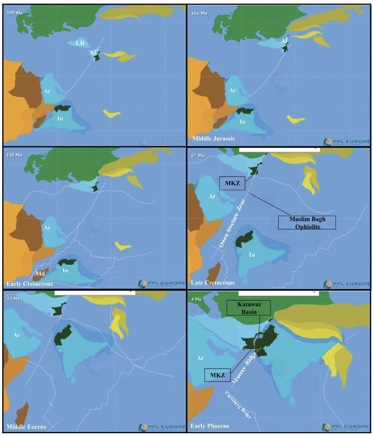
Figure-2 Plate Reconstruction of Indian Plate (PPL In-house Project). “In” for Indian Plate, “Ar” for Arabian Plate, “Af” for Afghan Block, “LB” for Lut Block, “MKZ” for Makran Subduction Zone . (PPL In-House G-Plate Project)
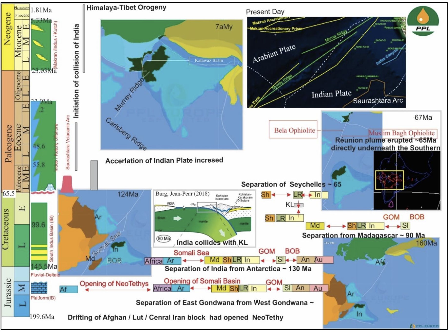
Figure-3. Major tectonic episodes of Indian from Gondwanaland to Asia showing sequential rifting of the Indian plate from Gondwanaland and its subsequent collisions Asia and development of Pakistan Offshore. “In” for Indian Plate, “Ar” for Arabian Plate, ‘An” for Antartica, “Au” for Australia, “Sr” for Siri Lanka, “Af” for Afghan Block, “KL” for Kohistan Ladakh , ‘Md” for Madgascar, “Sh” for Seychelles, “LR” for Laxmi Ridge, “GOM” for Gulf of Mannar and “BOB” for Bayof Bengal. (PPL In-House G-Plate Project)
INDUS OFFSHORE
The offshore Indus is passive and rift basin bounded on the north by the Badin Platform of Southern Indus Basin, Murray Ridge in east and to the south by the Saurashtara Arch. Continental crust is interpreted by previous worker as deep rift geometries for the area. Arial extension Indus Offshores Exclusive Economic Zone (EEZ) is 157,169 sq. km2. Indus Offshore is Atlantic type Passive margin basin. So far 13 wells were drilled in Indus Offshore. Pak 2-1 and Kekra-1 are drilled nearby the Saurashtara Volcanic Arch and could not be considered as part of Indus Offshore properly because thick Late Cretaceous basalt is present Fig.-4 is showing the wells drilled in Indus Offshore and adjacent Kutch Offshore basin.

Figure-4. Satellite imagery showing the oil and gas field in Kutch Offshore and Exploratory wells drilled in Indus offshore.
The geographical boundaries of this Indus Offshore are (i) the Murray Ridge to the northwest (ii) the present coastline to the northeast (iii) the abyssal plain of the Arabian Sea to the southwest and (iv) The maritime boundary between Pakistan and India to the east. The basin has three major tectonics plays namely as (i) Indus Delta Play (ii) Shelf Edge Carbonate Play (iii) Carbonates buildup over volcanic mounds in deep waters.
Despite of the major tectonic features of the Arabian Sea, the geomorphology of the continental shelf of the Pakistan Offshore is developed almost in the same pattern as the continental shelf all over the world (Solangi et al., 2019). Fig.-5b shows the passive continental slope in geological history that is southward prograde in the present days. The sediments were also prograde in geological history and shifted the continental shelf break toward the south. Fig. 4 is showing satellite imagery showing the oil and gas field in Kutch Offshore and Exploratory wells drilled in Indus offshore.
Geological cross section passive continental slope in geological history that is southward prograde in the present days is shown in Fig. 5. Satellite imagery showing the oil and gas field in Kutch Offshore and Exploratory wells drilled in Kutch Offshore is shown in Fig.6

Figure-5. Geological cross section passive continental slope in geological history that is southward prograde in the present days. (After Carmichael et al., 2009, Ahsan et al., 2011 and Gong et al., 2020fSS).
The Indus Delta is one of the largest sediment bodies in the ocean basins. The Indus Fan started building out during Late Oligocene to Early Miocene, directly related with the Himalayan orogeny. Its sedimentary record is important information on the uplift and erosion of the western Himalaya. New seismic and other available data now suggest that the Indus River and Fan system was initiated shortly after India-Asia collision at ~55 Ma.
The modern Indus drainage basin included the drainage of Higher Himalaya by the high peaks of the Karakoram, Kohistan and other tectonic units of the Indus Suture Zone. The Indus Canyon (Fig.-1) is a dominant feature of the of Indus delta which dissect the shelf to within 20 m water depth and 3.5 km of the coast. Giosan et al., considered the Indus delta as mid-shelf subaqueous clinoform on the basis of wave energy versus fluvial discharge delivery to open sea. Fig.-6 showing the oil and gas field in Kutch Offshore and Exploratory wells drilled in Kutch Offshore.
Data source: An overview of petroleum potential of Pakistan offshore. Shabeer Ahmed, Adeel Nazeer, Imran Khan, Khalid Amin Khan, Zahoor Khan, Khurram Shahzad, Azhar Khan, Rashid Mukhtar. 2022
Следующий Бассейн: Offshore Indus