Тип бассейна:
Подтип бассейна:
Класс бассейна:
Возраст бассейна:
Тип полезных ископаемых:
Геологический возраст начало:
Геологический возраст конец:
Площадь: 619725.06 км²
Karoo Basin of South Africa
The Karoo foreland basin is filled with over 5 km of Carboniferous to Early Jurassic sedimentary strata. The Early Permian-age Ecca Group underlies much of the Karoo Basin, cropping out along the southern and western basin margins, Table 1. The Ecca Group contains a sequence of organic-rich mudstone, siltstone, sandstone and minor conglomerates.
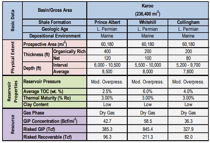
Table 1: Shale Gas Reservoir Properties and Resources of the Karoo Basin
Geologic Setting
The larger Ecca Group, encompassing an interval up to 10,000 ft thick in the southern portion of the basin, is further divided into the Upper Ecca (containing the Fort Brown and Waterford Formations) and the Lower Ecca (containing the Prince Albert, Whitehill and Collingham Formations), Figure 2.
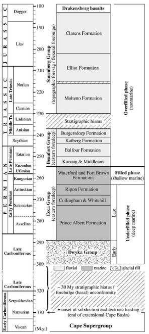
Figure 2. Stratigraphic Column of the Karoo Basin of South Africa
The three Lower Ecca formations are the subject of this shale resource assessment. The regional southwest to northeast cross-section illustrates the structure of the Cape Fold Belt of the Ecca Group on the south and the thermal maturity for the Ecca Group on the north, Figure 3.
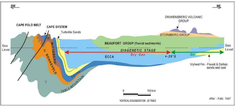
Figure 3. Schematic Cross-Section of Southern Karoo Basin and Ecca Group Shales
Major portions of the Karoo Basin have igneous (sill) intrusions and complex geology, with the most extensive and thickest sills concentrated within the Upper Ecca and Balfour formations. This unusual condition creates significant exploration risk in pursuing the shale resources in the Karoo Basin, Figure 4.(Note that this map reflects the maximum extent of intrusions, which are expected to be less within the target shale formations.) Local mapping indicates that contact metamorphism is restricted to quite close to the intrusions. As such, we removed 15% of the prospective area to account for the potential impact of igneous intrusions and significantly risked the remaining resource.
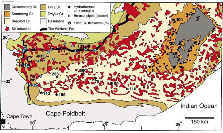
Figure 4. Igneous Intrusions in the Karoo Basin, South Africa
The prospective area for the Lower Ecca Group shales is estimated at 60,180 mi2, Figure 5. The boundaries of the prospective area are defined by the outcrop of the Upper Ecca Group on the east, south and west/northwest and the pinch-out of the Lower Ecca Group shales on the northeast, Figure 6. The dry gas window is south of the approximately 29o latitude line. Given the thermal maturity information and the depositional limits of the Lower Ecca shales, the prospective area of the Lower Ecca shales is primarily in the dry gas window.
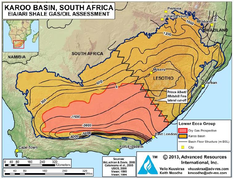
Figure 5. Lower Ecca Group Structure Map, Karoo Basin, South Africa
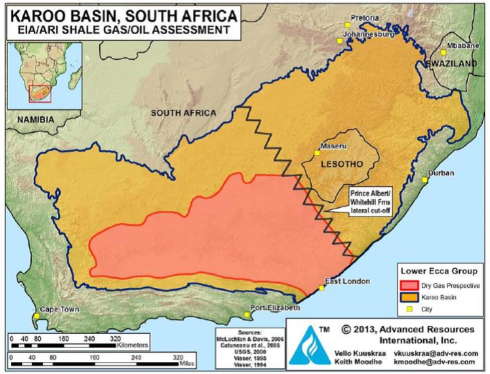
Figure 6: Outline of Karoo Basin and Prospective Shale Gas Area of South Africa
Reservoir Properties (Prospective Area)
Lower Ecca Shales. The Lower Ecca shales include the thick basal Prince Albert Formation, overlain by the thinner Whitehill and Collingham Formations. Each of these sedimentary units has been individually assessed and is discussed below.
Prince Albert Shale. The Lower Permian Prince Albert Formation has a thick, thermally mature area for shale gas in the Karoo Basin. Depth to the Prince Albert Shale ranges from 6,000 to over 10,000 ft, averaging about 8,500 ft in the deeper prospective area in the south.
The Prince Albert Shale has a gross thickness that ranges from 200 to 800 ft, averaging 400 ft, with a net organic-rich thickness of about 120 ft.
The total organic content (TOC) of the Prince Albert Shale within its organic-rich net pay interval ranges from 1.5 to 5.5%, averaging 2.5%, Figure 7. Local TOC values of up to 12% have been recorded. However, in areas near igneous intrusions much of the organic content may have been lost or converted to graphite.
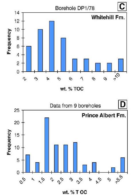
Figure 7. Total Organic Content of Prince Albert and Whitehill Formations
Because of the presence of igneous intrusions, the thermal maturity of the Prince Albert Shale is high, estimated at 2% to 4% Ro, placing the shale well into the dry gas window. In areas near igneous intrusions, the formation is over-mature, with vitrinite reflectance (Ro) values reaching 8%, indicating that the organic content has been transformed into graphite and CO2, Figure 8. The Prince Albert Shale was deposited as a deep marine sediment and is inferred to have mineralogy favorable for shale formation stimulation.
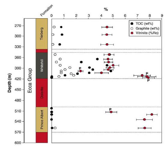
Figure 8. Carbon Loss in Lower Ecca Group Metamorphic Shale
Based on limited well data, primarily from the Cranemere CR 1/68 well completed in the Upper Ecca interval, the Prince Albert Shale appears to be overpressured and has a high thermal gradient.
Whitehill Shale. The organic-rich Lower Permian Whitehill Formation contains one of the main shale gas targets in the Karoo Basin of South Africa. The depth to the Whitehill Shale ranges from 5,500 to 10,000 ft, averaging 8,000 ft in the prospective area. The Whitehill Shale has an estimated gross organic thickness of 100 to 300 ft, with an average net thickness of 100 ft within the prospective area, as shown by the isopach map on Figure 9.
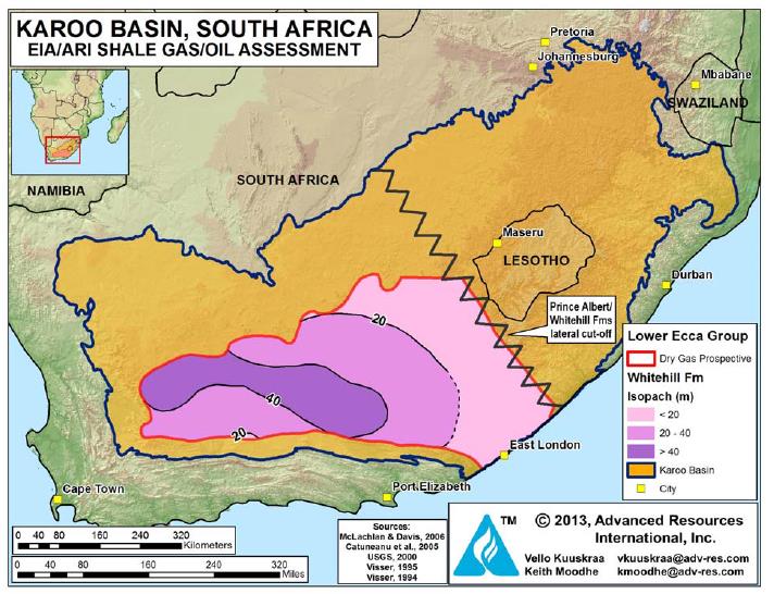
Figure 9. Isopach Map of the Whitehill Formation
The total organic content (TOC) for the Whitehill Shale in the prospective area ranges from 3% to 14%, averaging 6%. Local areas have TOC contents up to 15%. In areas near igneous intrusions, portions of the organic content may have been converted to graphite. The main minerals in the Whitehill Formation are quartz, pyrite, calcite and chlorite, making the shale favorable for hydraulic stimulation. The Whitehill Shale is assumed to be overpressured. The thermal maturity (Ro) of the Whitehill Shale in the prospective area ranges from 2% to 4%, placing the shale into the dry gas window.
The hydrogen and oxygen indexes of the Whitehill Formation indicate a mixture of Type I and Type II kerogen. The Whitehill Shales was deposited in deep marine, anoxic setting and contains minor sandy interbeds from distal turbidites and storm deposits.
Collingham Shale. The Lower Permian Collingham Formation (often grouped with the Whitehill Formation) contains the third shale formation addressed by this resource study. The Collingham Formation has an upward transition from deep-water submarine to shallow-water deltaic deposits. The depth to the Collingham Shale averages 7,800 ft within the prospective area. Except for total organic content, the shale has reservoir properties similar to the Whitehill Shale. It has an estimated gross organic thickness of 200 ft, a net thickness of 80 ft, and TOC of 2% to 8%, averaging 4%. Thermal maturity is high, estimated at 3% Ro, influenced by igneous intrusions. The shale is assumed to be overpressured based on data from the Upper Ecca Group.
Upper Ecca Shales. The Upper Ecca Formation extends over a particularly thick, 1,500 m (~5,000 ft) vertical interval in the central and northern Karoo Basin. The Upper Ecca contains two shale sequences of interest - - the Waterford and the Fort Brown. The Fort Brown Formation accounts for the great bulk of the vertical interval of the Upper Ecca. These shales are interpreted by some investigators to have been deposited in a shallow marine environment, although others categorize them as lacustrine.
The organic content and thermal maturity of the Upper Ecca shales are considerably less than for the Lower Ecca shales. The total organic content (TOC) is reported to range from about 1% to 2%. With a thermal maturity ranging from 0.9% to 1.1% Ro, the Upper Ecca shales area is in the oil to wet gas window.
In the materials below, we provide a qualitative description for the Upper Ecca shales. However, because their average TOC is below the 2% criterion set for the study, these shales have been excluded from our quantitative assessment.
The boundaries of the prospective area for the Upper Ecca shales are defined by the outcrop of the Upper Ecca on the east, south and west and the shallowing of the Lower Ecca shales on the northeast. The shale oil window is north of the approximately 29o latitude line. A significant basalt intrusion area of about 10,000 mi2 in the center of the prospective area has been excluded. Major portions of the prospective area have igneous intrusions that have locally destroyed portions of the organics, creating significant exploration risk.
Fort Brown Shale. The Fort Brown Shale, as described in the Cranemere CR 1/68 well, is a dark gray to black shale with occasional siltstone stringers. In this well, the Fort Brown Shale exists over a gross interval of nearly 5,000 ft (1,500 m) from 7,012-11,997 ft. Sunset Energy, the current permit holder in the area surrounding the Cranemere CR 1/68 well, reports that 24-hour DST testing in one interval of the Fort Brown shale, from 8,154-8,312 ft, had a flow rate of 1.84 MMcfd. The well is reported to have blown out at a depth of about 8,300 ft (2,500 m), requiring 10.5 pound per gallon mud to bring the well under control.
The prospective area for the Upper Ecca Fort Brown Shale is estimated at 31,700 mi2.
The Fort Brown Shale in the prospective area has an average depth of 6,000 ft and ranges from 3,000 to 9,000 ft. The shale has an estimated 600 ft of net organic rich thickness, based on using a net to gross ratio of 20% and an average gross thickness of 3,000 ft. The shale has a total organic content (TOC) that ranges from 1 to 2% and an estimated average thermal maturity of 1.1% Ro (based on limited data).
Waterford Shale. The prospective area for the Upper Ecca Waterford Shale is estimated at 20,800 mi2. The Waterford Shale in the prospective area has an average depth of 4,500 ft, ranging from 3,000 to 6,000 ft. The shale has an estimated 100 ft of net organic rich thickness within an average gross thickness of 500 ft. Total organic content ranges from 1 to 2%, with average thermal maturity, based on very limited data, of 0.9% Ro.
Resource Assessment
Prince Albert Shale. Within its 60,180-mi2 dry gas prospective area, the Prince Albert Shale has a resource concentration of about 43 Bcf/mi2. Given limited exploration data, the risked shale gas in-place is estimated at 385 Tcf. Based on favorable TOC and reservoir mineralogy, balanced by complex geology and volcanic intrusions in the prospective area, ARI estimates a risked, technically recoverable shale gas resource of 77 Tcf for the Prince Albert Shale in the Karoo Basin.
Whitehill Shale. Within its 60,180-mi2 dry gas prospective area, the Whitehill Shale has a resource concentration of about 59 Bcf/mi2. While somewhat more defined than the Prince Albert Shale, the exploration risk for the Whitehill Shale is still substantial, leading to a risked shale gas in-place of 845 Tcf. Based on favorable reservoir mineralogy but complex geology, ARI estimates a risked, technically recoverable shale gas resource of 211 Tcf for the Whitehill Shale in the Karoo Basin.
Collingham Shale. With a prospective area of 60,180 mi2 and with a resource concentration of 36 Bcf/mi2, the risked gas in-place for the Collingham Shale is estimated at 328 Tcf, with a risked, technically recoverable shale gas resource of 82 Tcf.
Considerable uncertainty surrounds the characterization and assessment of the shale oil resources of South Africa, particularly for the net organic-rich thickness and the vertical and areal distribution of thermal maturity. Shale exploration is just starting in the Karoo Basin and few data points exist, particularly for the Upper Ecca group of formations.
Recent Activity
Falcon Oil & Gas Ltd., an early entrant into the shale gas play of South Africa, obtained an 11,600-mi2 TCP along the southern edge of the Karoo Basin. Shell obtained a larger 71,400-mi2 TCP surrounding the Falcon area. Sunset Energy holds a 1,780-mi2 TCP to the west of Falcon. The Sasol/Chesapeake/Statoil JV TCP area of 34,000 mi2 and the Anglo Coal TCP application area of 19,300 mi2 are to the north and east of Shell’s TPC, Figure 10.
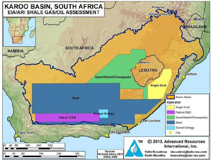
Figure 10. Map Showing Operator Permits in the Karoo Basin, South Africa
Recently, Chevron announced that it would partner with Falcon Oil & Gas to pursue the shale resources of the Karoo Basin, starting with seismic studies.
Five older (pre-1970) wells have penetrated the Ecca Shale interval. Each of the wells had gas shows, while one of the wells - - the Cranemere CR 1/68 well - - flowed 1.84 MMcfd from a test zone at 8,154 to 8,312 ft. The gas production, considered to be from fractured shale, depleted relatively rapidly during the 24-hour test. The CR 1/68 well was drilled to 15,282 ft into the underlying Table Mountain quartzite and had gas shows from six intervals, starting at 6,700 ft and ending at 14,650 ft, indicating that the shales in this area are gas saturated.
Data source:SOUTH AFRICA, Advanced Resources International. Vello Kuuskraa, Keith Moodhe, 2013
Следующий Бассейн: Douala Ultradeep