 >
>Тип бассейна: Платформ
Подтип бассейна: Пассивных окраин (перикратонно-океанический)
Класс бассейна: Периокеанический
Возраст бассейна: Зрелый - Мезозойский
Тип полезных ископаемых:
Геологический возраст начало:
Геологический возраст конец:
Площадь: 250685.73 км²
Tertiary Niger Delta (Akata-Agbada) Petroleum System (No. 701901), Niger Delta Province, Nigeria, Cameroon, and Equatorial Guinea, Africa
by Michele L. W. Tuttle, Michael E. Brownfield, and Ronald R. Charpentier
ABSTRACT
In the Niger Delta province, we have identified one petroleum system--the Tertiary Niger Delta (Akata-Agbada) petroleum system. The delta formed at the site of a rift triple junction related to the opening of the southern Atlantic starting in the Late Jurassic and continuing into the Cretaceous. The delta proper began developing in the Eocene, accumulating sediments that now are over 10 kilometers thick. The primary source rock is the upper Akata Formation, the marine-shale facies of the delta, with possibly contribution from interbedded marine shale of the lowermost Agbada Formation. Oil is produced from sandstone facies within the Agbada Formation, however, turbidite sand in the upper Akata Formation is a potential target in deep water offshore and possibly beneath currently producing intervals onshore.
Known oil and gas resources of the Niger Delta rank the province as the twelfth largest in the world. To date, 34.5 billion barrels of recoverable oil and 93.8 trillion cubic feet of recoverable gas have been discovered. In 1997, Nigeria was the fifth largest crude oil supplier to the United States, supplying 689,000 barrels/day of crude.
INTRODUCTION
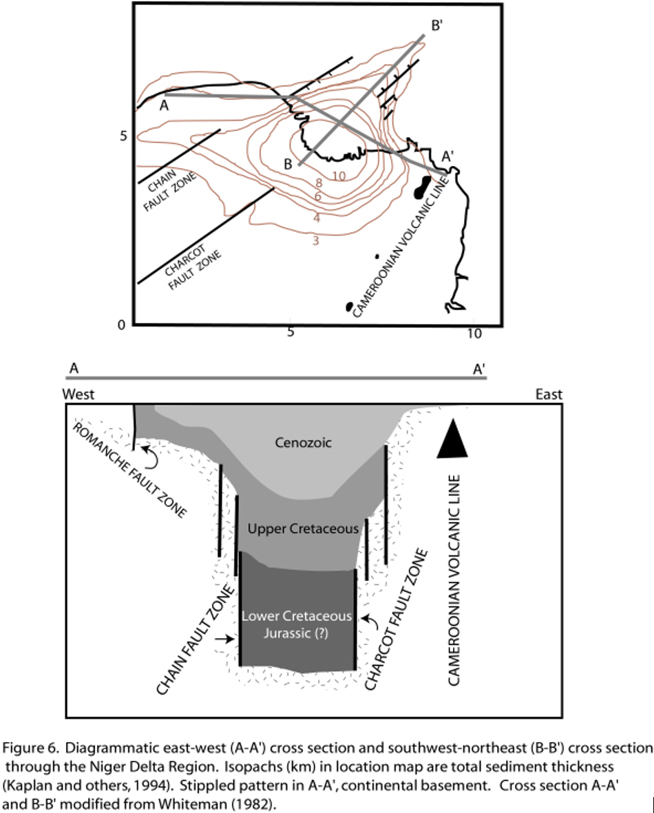
The Niger Delta is situated in the Gulf of Guinea (fig. 1) and extends throughout the Niger Delta Province as defined by Klett and others (1997). From the Eocene to the present, the delta has prograded southwestward, forming depobelts that represent the most active portion of the delta at each stage of its development (Doust and Omatsola, 1990). These depobelts form one of the largest regressive deltas in the world with an area of some 300,000 km2 (Kulke, 1995), a sediment volume of 500,000 km3 (Hospers, 1965), and a sediment thickness of over 10 km in the basin depocenter (Kaplan and others, 1994).
>
The Niger Delta Province contains only one identified petroleum system (Kulke, 1995; Ekweozor and Daukoru, 1994; this study). This system is referred to here as the Tertiary Niger Delta (Akata –Agbada) Petroleum System.1 The maximum extent of the petroleum system coincides with the boundaries of the province (fig. 1). The minimum extent of the system is defined by the areal extent of fields and contains known resources (cumulative production plus proved reserves) of 34.5 billion barrels of oil (BBO) and 93.8 trillion cubic feet of gas2 (TCFG) (14.9 billion barrels of oil equivalent, BBOE) (Petroconsultants, 1996a). Currently, most of this petroleum is in fields that are onshore or on the continental shelf in waters less than 200 meters deep (fig. 1), and occurs primarily in large, relatively simple structures. A few giant fields do occur in the delta, the largest contains just over 1.0 BBO (Petroconsultants, Inc., 1996a). Among the provinces ranked in the U.S. Geological Survey's World Energy Assessment (Klett and others, 1997), the Niger Delta province is the twelfth richest in petroleum resources, with 2.2% of the world’s discovered oil and 1.4% of the world’s discovered gas (Petroconsultants, Inc. 1996a).
In 1908, the German Nigerian Bitumen Corporation drilled the first wells in the vicinity of the tar seep deposits in the northern portion of the delta (Frost, 1997). However, significant oil shows were not found in Tertiary rocks until the early 1950’s. Shell-British Petroleum brought the first well on stream in 1958 at 5,100 barrels per day. From 1958 until the Biafran War in 1967, exploration and production increased in Nigeria. The war curtailed both activities until its end in 1970, when world oil prices were rising and Nigeria again could benefit economically from its petroleum resources in the Niger Delta. In 1971, Nigeria joined the Organization of the Petroleum Exporting Countries (OPEC) with a total production of 703 million barrels of oil (MMBO) per annum.
In 1997, production rose to 810 MMBO (Energy Information Administration, 1998a). Thirty-one percent of this production (251 MMBO) was exported to the United States, making Nigeria the fifth largest supplier of U.S. oil. Despite the political uncertainty in Nigeria today, the country’s sustainable production capacity is expected to increase over current production--they have agreed, however, to reduce their production by 225,000 barrels/day in 1998. Petroleum exploration is also expanding, especially in deeper water offshore, with the Nigerian government currently planning to offer six additional lease blocks in water up to 3000 m deep. Considering both oil and gas, the overall success ratio for exploration drilling is as high as 45% (Kulke, 1995; figs. 2A and 2B).
Exploration of the small portions of the Niger Delta in Cameroon and Equatorial Guinea began much later than in Nigeria. Recoverable oil and gas (produced plus proved reserves) are much smaller than in Nigeria. In 1997, 96% of the Niger Delta recoverable petroleum was in Nigeria, 3.5% in Cameroon, and 0.5% in Equatorial Guinea (Petroconsultants, Inc., 1996a).

Acknowledgements. The authors wish to acknowledge T. Klett, F. Persits, and L. Osmonson of the U.S. Geological Survey for assistance with data and maps; .Petroconsultants Group and Geomark Research, Inc.; and L. Magoon, G. Ulmishek, and G. Dolton for thoughtful reviews of the manuscript.
PROVINCE GEOLOGY
The onshore portion of the Niger Delta Province is delineated by the geology of
southern Nigeria and southwestern Cameroon (fig. 1). The northern
boundary is the Benin flank--an east-northeast trending hinge line south of the
West Africa basement massif. The northeastern boundary is defined by outcrops
of the Cretaceous on the Abakaliki High and further east-south-east by the
Calabar flank--a hinge line bordering the adjacent Precambrian. The offshore
boundary of the province is defined by the Cameroon volcanic line to the east,
the eastern boundary of the Dahomey basin (the eastern-most West African
transform-fault passive margin) to the west, and the two-kilometer sediment
thickness contour or the 4000-meter bathymetric contour in areas where sediment
thickness is greater than two kilometers to the south and southwest. The
province covers 300,000 km2 and includes the geologic extent of
the Tertiary Niger Delta (Akata-Agbada) Petroleum System.
Tectonics
The tectonic framework of the continental margin along the West Coast of
equatorial Africa is controlled by Cretaceous fracture zones expressed as
trenches and ridges in the deep Atlantic. The fracture zone ridges subdivide
the margin into individual basins, and, in Nigeria, form the boundary faults of
the Cretaceous Benue-Abakaliki trough, which cuts far into the West African
shield. The trough represents a failed arm of a rift triple junction associated
with the opening of the South Atlantic. In this region, rifting started in the
Late Jurassic and persisted into the Middle Cretaceous (Lehner and De
Ruiter, 1977). In the region of the Niger Delta, rifting diminished altogether
in the Late Cretaceous. Figure 3 shows the gross paleogeography of the region
as well as the relative position of the African and South American plates since
rifting began.

 >
>
After rifting ceased, gravity tectonism became the primary deformational process. Shale mobility induced internal deformation and occurred in response to two processes (Kulke, 1995). First, shale diapirs formed from loading of poorly compacted, over-pressured, prodelta and delta-slope clays (Akata Fm.) by the higher density delta-front sands (Agbada Fm.). Second, slope instability occurred due to a lack of lateral, basinward, support for the under-compacted delta-slope clays (Akata Fm. ) (fig. 4). For any given depobelt, gravity tectonics were completed before deposition of the Benin Formation and are expressed in complex structures, including shale diapirs, roll-over anticlines, collapsed growth fault crests, back-to-back features, and steeply dipping, closely spaced flank faults (Evamy and others, 1978; Xiao and Suppe, 1992). These faults mostly offset different parts of the Agbada Formation and flatten into detachment planes near the top of the Akata Formation.
 >
>
Lithology
The Cretaceous section has not been penetrated beneath the Niger Delta Basin,
the youngest and southernmost sub-basin in the Benue-Abakaliki trough (Reijers
and others, 1997). Lithologies of Cretaceous rocks deposited in what is now the
Niger Delta basin can only be extrapolated from the exposed Cretaceous section
in the next basin to the northeast--the Anambra basin (fig. 5). From the
Campanian through the Paleocene, the shoreline was concave into the Anambra
basin (Hospers, 1965) (see fig. 3a and fig. 3b in
this paper), resulting in convergent longshore drift cells that produced
tide-dominated deltaic sedimentation during transgressions and river-dominated
sedimentation during regressions (Reijers and others, 1997). Shallow marine
clastics were deposited farther offshore and, in the Anambra basin, are
represented by the Albian-Cenomanian Asu River shale, Cenomanian-Santonian
Eze-Uku and Awgu shales, and Campanian/Maastrichtian Nkporo shale, among others
(fig. 5 ,fig 6a, and fig 6b) (Nwachukwu, 1972;
Reijers and others, 1997). The distribution of Late Cretaceous shale beneath
the Niger Delta is unknown.

 >
>
In the Paleocene, a major
transgression (referred to as the Sokoto transgression by Reijers and others,
1997) began with the Imo shale being deposited in the Anambra Basin to the
northeast and the Akata shale in the Niger Delta Basin area to the southwest (fig.
5). In the Eocene, the coastline shape became convexly curvilinear, the
longshore drift cells switched to divergent, and sedimentation changed to being
wave-dominated (Reijers and others, 1997). At this time, deposition of paralic
sediments began in the Niger Delta Basin proper and, as the sediments prograded
south, the coastline became progressively more convex seaward. Today, delta
sedimentation is still wave-dominated and longshore drift cells divergent
(Burke, 1972).
The Tertiary section of the Niger Delta is divided into three formations, representing prograding depositional facies that are distinguished mostly on the basis of sand-shale ratios. The type sections of these formations are described in Short and Stäuble (1967) and summarized in a variety of papers (e.g. Avbobvo, 1978; Doust and Omatola, 1990; Kulke, 1995). The Akata Formation at the base of the delta is of marine origin and is composed of thick shale sequences (potential source rock), turbidite sand (potential reservoirs in deep water), and minor amounts of clay and silt (fig. 5, fig. 6a, fig 6b, and fig. 7). Beginning in the Paleocene and through the Recent, the Akata Formation formed during lowstands when terrestrial organic matter and clays were transported to deep water areas characterized by low energy conditions and oxygen deficiency (Stacher, 1995). Little of the formation has been drilled; therefore, only a structural map of the top of the formation is available (fig. 8A). It is estimated that the formation is up to 7,000 meters thick (Doust and Omatsola, 1990). The formation underlies the entire delta, and is typically overpressured. Turbidity currents likely deposited deep sea fan sands within the upper Akata Formation during development of the delta (Burke, 1972).


Deposition of the overlying
Agbada Formation, the major petroleum-bearing unit, began in the Eocene and
continues into the Recent (fig. 5, fig. 6a, fig 6b,
and fig. 7). The formation consists of paralic siliciclastics over
3700 meters thick (Fig. 8B) and represents the actual deltaic portion of
the sequence. The clastics accumulated in delta-front, delta-topset, and
fluvio-deltaic environments. In the lower Agbada Formation, shale and sandstone
beds were deposited in equal proportions, however, the upper portion is mostly
sand with only minor shale interbeds. The Agbada Formation is overlain by the
third formation, the Benin Formation, a continental latest Eocene to Recent
deposit of alluvial and upper coastal plain sands that are up to 2000 m thick (Avbovbo,
1978).
Depobelts
Deposition of the three formations occurred in each of the five offlapping
siliciclastic sedimentation cycles that comprise the Niger Delta. These
cycles (depobelts) are 30-60 kilometers wide, prograde southwestward 250
kilometers over oceanic crust into the Gulf of Guinea (Stacher, 1995), and are
defined by synsedimentary faulting that occurred in response to variable rates
of subsidence3 and
sediment supply (Doust and Omatsola, 1990). The interplay of subsidence and
supply rates resulted in deposition of discrete depobelts--when further crustal
subsidence of the basin could no longer be accommodated, the focus of sediment
deposition shifted seaward, forming a new depobelt (Doust and Omatsola, 1990).
Each depobelt is a separate unit that corresponds to a break in regional dip of
the delta and is bounded landward by growth faults and seaward by large
counter-regional faults or the growth fault of the next seaward belt (Evamy and
others, 1978; Doust and Omatsola, 1990). Five major depobelts are generally
recognized, each with its own sedimentation, deformation, and petroleum history
(fig. 9).
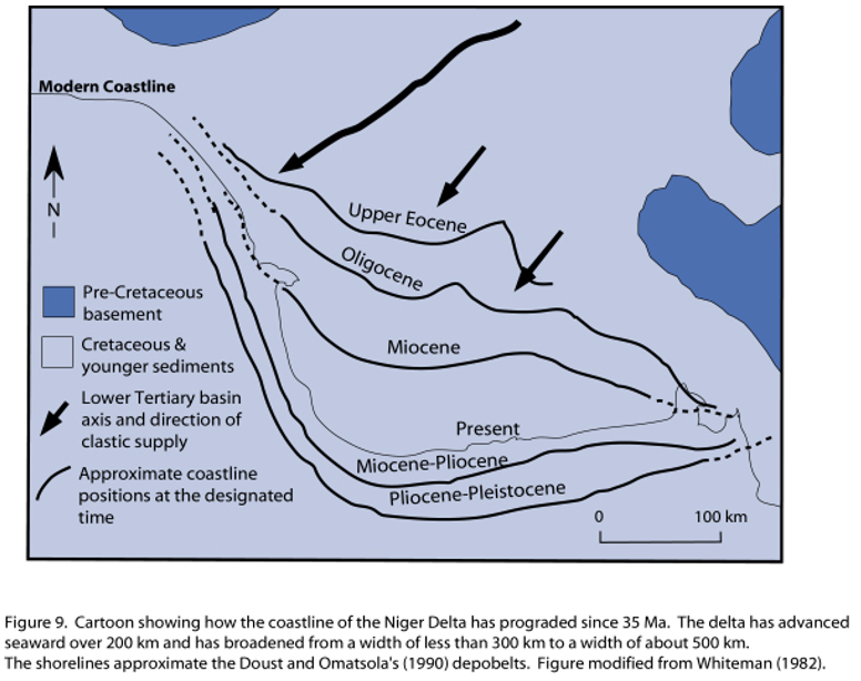
Doust and Omatsola (1990) describe three depobelt provinces based on structure. The northern delta province, which overlies relatively shallow basement, has the oldest growth faults that are generally rotational, evenly spaced, and increase their steepness seaward. The central delta province has depobelts with well-defined structures such as successively deeper rollover crests that shift seaward for any given growth fault. Last, the distal delta province is the most structurally complex due to internal gravity tectonics on the modern continental slope.
PETROLEUM AND ITS OCCURRENCE
Distribution of Petroleum
Petroleum occurs throughout the Agbada Formation of the Niger Delta (fig. 1),
however, several directional trends form an "oil-rich belt" having
the largest field and lowest gas:oil ratio (Ejedawe, 1981; Evamy and others;
1978; Doust and Omatsola, 1990). The belt extends from the northwest offshore
area to the southeast offshore and along a number of north-south trends in the
area of Port Harcourt (fig. 10). It roughly corresponds to the
transition between continental and oceanic crust, and is within the axis of
maximum sedimentary thickness (see isopach map in fig. 6a). This
hydrocarbon distribution was originally attributed to timing of trap formation
relative to petroleum migration (earlier landward structures trapped earlier
migrating oil). Evamy and others (1978), however, showed that in many
rollovers, movement on the structure-building fault and resulting growth
continued and was relayed progressively southward into the younger part of the
section by successive crestal faults, concluding that there was no relation
between growth along a fault and distribution of petroleum. Ejedawe (1981)
relates the position of the oil-rich areas within the belt to five delta lobes
fed by four different rivers. He states that the two controlling factors are an
increase in geothermal gradient relative to the minimum gradient in the delta
center and the generally greater age of sediments within the belt relative to
those further seaward. Together these factors gave the sediments within the
belt the highest "maturity per unit depth." Weber (1987) indicates
that the oil-rich belt ("golden lane") coincides with a concentration
of rollover structures across depobelts having short southern flanks and little
paralic sequence to the south. Doust and Omatsola (1990) suggest that the
distribution of petroleum is likely related to heterogeneity of source rock
type (greater contribution from paralic sequences in the west) and/or
segregation due to remigration. Haack and others (1997) relate the position of
the oil-rich belt to oil-prone marine source rocks deposited adjacent to the
delta lobes (fig. 10), and suggest that the accumulation of these source
rocks was controlled by pre-Tertiary structural sub-basins related to basement
structures.
 >
>
Outside of the "oil-rich belt" (central, easternmost, and northernmost parts of the delta), the gas:oil ratios (GOR) are high. The GOR within each depobelt increases seaward and along strike away from depositional centers. Causes for the distribution of GOR’s are speculative and include remigration induced by tilting during the latter history of deposition within the downdip portion of the depobelt, updip flushing of accumulations by gas generated at higher maturity, and/or heterogeneity of source rock type (Doust and Omatsola, 1990).
Stacher (1995), using sequence stratigraphy, developed a hydrocarbon habitat model for the Niger Delta (fig. 11). The model was constructed for the central portion of the delta, including some of the oil-rich belt, and relates deposition of the Akata Formation (the assumed source rock) and the sand/shale units in the Agbada Formation (the reservoirs and seals) to sea level. Pre-Miocene Akata shale was deposited in deep water during lowstands and is overlain by Miocene Agbada sequence system tracts. The Agbada Formation in the central portion of the delta fits a shallow ramp model with mainly highstand (hydrocarbon-bearing sands) and trangressive (sealing shale) system tracts--third order lowstand system tracts were not formed. Faulting in the Agbada Formation provided pathways for petroleum migration and formed structural traps that, together with stratigraphic traps, accumulated petroleum. The shale in the transgressive system tract provided an excellent seal above the sands as well as enhancing clay smearing within faults.
 >
>
Properties of Petroleum
Fields
Most fields consist of a number of individual reservoirs that contain oil of
varying composition with different gas/oil ratios. Gas caps are common. Many
reservoirs are overpressured and primary production is mainly from gas
expansion (Kulke, 1995). Common oil production problems include water coning,
unconsolidated sands, wax deposition and high gas/oil ratios (see below),
leading to ultimate recovery rates up to 30% (Kulke, 1995). The size and depth
distribution of oil and gas fields is shown in Figure 12.
 >
>
Properties of Oil and Gas
The physical and chemical properties of the oil in the Niger Delta are highly
variable, even down to the reservoir level. Organic geochemical profiles for a
nonbiodegraded and moderately biodegraded Niger Delta oil are summarized in
Figure 13. The oil within the delta has a gravity range of 16-50°
API, with the lighter oils having a greenish-brown color (Whiteman 1982).
Fifty-six percent of Niger Delta oils have an API gravity between 30° and 40°
(Thomas, 1995). Most oils fall within one of two groups. The first group are
light paraffin based, waxy oils from deeper reservoirs (wax content up to 20%,
but commonly around 5%; Kulke, 1995; Doust and Omatsola, 1990; high
n-paraffin/naphthene of 0.86, fig. 13). The second group of oils
are biodegraded and from shallow reservoirs. They have lower API gravity
(average API of 26°; Kulke, 1995) and are naphthenic non-waxy oils
(n–paraffin/naphthene = 0.37, fig. 13). Biodegradation and washing
is extreme in some Pleistocene sands of the Agbada Formation, forming extra
heavy oils (API 8-20°). Oils with less than 25° API account for only 15% of the
Niger Delta reserves (Thomas, 1995). The concentration of sulfur in most oils
is low, between 0.1 % and 0.3 % (Mbendi, 1996), with a few samples having
concentrations as high as 0.6 % (Nwachukwu and others, 1995). A limited data
set (Mbendi, 1996; Nwachuku and others, 1995) shows a negative correlation
between API gravity and sulfur content, suggesting that sulfur content is
likely related to oil degradation. This trend, however, is not seen in the data
presented in Figure 13.
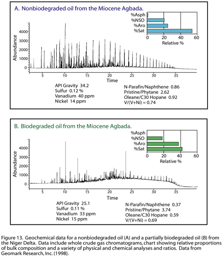
Oils derived from terrestrial organic matter such as those in the Niger Delta have high pristane:phytane ratios (fig. 13). If the oils are derived from terrestrial organic matter younger than mid-Cretaceous, then the oleanane:C30-hopane ratios are high as well (fig. 13).4
Concentrations of Ni and V in Niger Delta oils are less than 100 and V/(V+Ni) values range between 0.01 and 0.41 with an average of 0.12 ppm (Nwachukwu and others, 1995), consistent with values in oils derived from Type III organic matter (Lewan and Maynard, 1982). Concentrations of sulfur and V/(V+Ni) in Niger Delta oil, place the Niger Delta source rocks in Lewan’s (1984) Regime II with respect to source-rock depositional conditions. These trace-metal data, together with the organic geochemistry and physical properties of the oil indicate that the Niger Delta source rocks contain predominately terrestrial organic matter. The organic matter was deposited in suboxic-anoxic bottom waters where vanadyl and nickel availability for bonding was hindered in part by formation of hydroxides and complexing with metastable sulfide ions, respectively. Preservation of the organic matter would be quite good under these conditions.
The associated gas in the Niger Delta is thermal in origin (d13C values of -36 to 40‰; Doust and Omatsola, 1990), with low CO2 and N2 concentrations. Hydrogen sulfide is not a problem associated with Niger Delta gas; however, relatively high mercury concentrations have been observed. Currently, 75 % of the gas produced from the Niger Delta is flared5, 10% is reinjected to maintain reservoir pressure, and only 15% marketed. (Energy Information Administration, 1998b).
SOURCE ROCK
Source Rock Identification
There has been much discussion about the source rock for petroleum in the Niger
Delta (e.g. Evamy and others, 1978; Ekweozor and others, 1979; Ekweozor and
Okoye, 1980; Lambert-Aikhionbare and Ibe, 1984; Bustin, 1988; Doust and
Omatsola, 1990). Possibilities include variable contributions from the marine
interbedded shale in the Agbada Formation and the marine Akata shale, and a
Cretaceous shale (Weber and Daukoru, 1975; Evamy and others, 1978; Ejedawe and
others, 1979; Ekweozor and Okoye, 1980; Ekweozor and Daukoru, 1984;
Lambert-Aikhionbare and Ibe, 1984; Doust and Omatsola, 1990; Stacher, 1995;
Frost, 1977; Haack and others, 1997).
Agbada-Akata
The Agbada Formation has intervals that contain organic-carbon contents
sufficient to be considered good source rocks (see data in Ekweozor and Okoye,
1980; Nwachukwu and Chukwura, 1986). The intervals, however, rarely reach
thickness sufficient to produce a world-class oil province and are immature in
various parts of the delta (Evamy and others, 1978; Stacher, 1995). The Akata
shale is present in large volumes beneath the Agbada Formation (fig. 8A)
and is at least volumetrically sufficient to generate enough oil for a world
class oil province such as the Niger Delta.
Based on organic-matter content and type, Evamy and others (1978) proposed that both the marine shale (Akata Fm.) and the shale interbedded with paralic sandstone (lower Agbada Fm.) were the source rocks for the Niger Delta oils.
Ekweozor and others (1979) used ab-hopanes and oleananes to fingerprint crude with respect to their source--the shale of the paralic Agbada Formation on the eastern side of the delta and the Akata marine-paralic source on the western side of the delta. Ekweozor and Okoye (1980) further constrained this hypothesis using geochemical maturity indicators, including vitrinite reflectance data, that showed rocks younger than the deeply buried lower parts of the paralic sequence to be immature. Lambert-Aikhionbare and Ibe (1984) argued that the migration efficiency from the over-pressured Akata shale would be less than 12%, indicating that little fluid would have been released from the formation. They derived a different thermal maturity profile, showing that the shale within the Agbada Formation is mature enough to generate hydrocarbons. [See discussion about expulsion from abnormally pressured source rocks in the section on Petroleum Generation, Migration and Accumulation.]
Ejedawe and others (1984) use maturation models to conclude that in the central part of the delta, the Agbada shale sources the oil while the Akata shale sources the gas. In other parts of the delta, they believe that both shales source the oil. Doust and Omatsola (1990) conclude that the source organic matter is in the deltaic offlap sequences and in the sediments of the lower coastal plain. Their hypothesis implies that both the Agbada and Akata Formations likely have disseminated source rock levels, but the bulk will be in the Agbada Formation. In deep water, they favor delta slope and deep turbidite fans of the Akata Formation as source rocks. The organic matter in these environments still maintains a terrestrial signature, however, it may be enriched in amorphous, hydrogen-rich matter from bacterial degradation. Stacher (1995) proposes that the Akata Formation is the only source rock volumetrically significant and whose depth of burial is consistent with the depth of the oil window.
Cretaceous![]()
Some have proposed that marine Cretaceous shale beneath the Niger Delta is a
viable source rock (e.g. pre-Albian super source rock; Frost, 1997). This
Cretaceous section has never been drilled beneath the delta due to its great
depth; therefore, no data exist on its source-rock potential. Migration of oil
from the Cretaceous into the reservoirs in the Agbada Formation would have
required an intricate fault/fracture network as the Akata shale reaches a
thickness greater than 6,000 meters. No data exist to support such a network.
The chemical composition of the oils provides conflicting evidence for the
hypothesis of a Cretaceous source rock, especially for an Early Cretaceous one.
Nwachukwu and others (1995) report low V:V+Ni ratios in Niger Delta crude (0.12),
a ratio quite smaller than the ratio in Cretaceous oils in onshore seeps in the
northern portion of the province (0.46; Oluwole and others, 1985 as cited in
Kulke, 1995). The V+Ni ratios for Miocene oils reported in 1998 by Geomark
Research Inc. (fig. 13), however, are similar to those in the Cretaceous
oils. Significant oleanane is found in Niger Delta crude. This compound is
related to angiosperms, which only became wide spread in the Late
Cretaceous-Tertiary. Haack and others (1997) use the northern Gulf of Mexico
Basin model of older rocks sourcing oils in deeper water to suggest that oil in
hypothetical deep-water plays of the Niger Delta may be sourced, in part, by
Upper Cretaceous rocks. As these oils are in hypothetical plays, no geochemical
data are available yet to test such a hypothesis in the Niger Delta.
Source Rock Chemical Characteristics
Bustin (1988), in a detailed source-rock study on side-wall core and cuttings
from the Agbada-Akata transition or uppermost Akata Formation, concluded that
there are no rich source rocks in the delta. With respect to oil potential,
Bustin claims that the poor source-rock quality has been more than compensated
by their great volume, excellent migration pathways, and excellent drainage.
The oil potential is further enhanced by permeable interbedded sandstone and
rapid hydrocarbon generation resulting from high sedimentation rates. The total
organic-carbon (TOC) content of sandstone, siltstone, and shale in his study is
essentially the same (average of 1.4 to 1.6% TOC). The content, however, seems
to vary with age of the strata—a trend of decreasing content with decreasing
age (average of 2.2% in the late Eocene compared to 0.9% in Pliocene strata).
Bustin’s Eocene TOC average compares well with the averages of 2.5% and 2.3%
obtained for Agbada-Akata shales in two wells (Udo and Ekweozor, 1988).
Ekeweozor and Okoye (1980) report TOC values from 0.4 to 14.4% in the both
onshore and offshore paralic sediments. Nwachukwu and Chukwura (1986) report
values as high as 5.2% in paralic shales from the western part of the delta.
The higher TOC contents are limited to thin beds and are only easily recognized
in conventional cores (Doust and Omatsola, 1990).
The organic matter consists of mixed maceral components (85-98% vitrinite with some liptinites and amorphous organic matter) (Bustin, 1988). There is no evidence of algal matter and the shales are low in sulfur (.02 to .1 %). Hydrogen indices (HI) are quite low and generally range from 160 to less than 50 mg HC/g TOC. Ekweozor and Daukoru (1994) believe that Bustin’s average of 90 mg HC/g TOC underestimates the true source-rock potential because of matrix effects on whole-rock pyrolysis of deltaic rocks. Udo and others (1988) report HI values of 232 for immature kerogen isolates from Agbada-Akata shales. HI values over 400 have been measured (U.S. Geological Survey, unpublished proprietary data).
Pristane/phytane in extracts range between 2 and 4 (Bustin, 1988). Bustin found that both HI values and pristane/phytane change with stratigraphic position similarly to TOC contents (lower values in younger strata). He attributes these stratigraphic trends in organic-matter to increased dilution as sedimentation rates increased and possibly an increase in oxidizing conditions of the depositional environment.
Source Rock Potential
Demaison and Huizinga (1994) have estimated the average source potential index
(SPI) for the Niger Delta at 14 t HC/m2. Given that the Niger Delta
is a vertically drained system (drainage area small), the SPI value is in the
upper portion of the medium range of worldwide values. SPI is calculated as
follows:
SPI (in metric tons HC/m2) = h(S1+S2)r/1000
where h is thickness of source rock in meters, S1+S2 is the average genetic potential in kilograms of HC per metric ton of rock, and r is the rock density in metric tons per cubic meter (Demaison and Huizinga, 1994). Using a genetic potential of 7.5 kg/t (median of U.S. Geological Survey unpublished proprietary Niger Delta data) and assuming a density of 2.26 g/cm3 (Michael Lewan, U.S. Geological Survey, written communication, 1999), the thickness of source rocks required by the above equation is 825 meters. This is much larger than the 100 to 300 meter thickness calculated using material balance equations (Michael Lewan, U.S. Geological Survey, written communication, 1999) as summarized in Chapter B. One hundred to 300 meters of mature source rock could be easily accommodated in the mature, lower portion of the Agbada Formation and the uppermost Akata Formation.
We agree with researchers (Evamy and others, 1978 among others) who believe that both formations are source rocks for the Niger Delta oil. The two formations are just different facies within the same depositional system and likely contain similar organic matter. Each formation contributes variably to the hydrocarbons generated, depending on the location within the delta and the depth of burial. Based on proposed migration pathways, oil composition, and a variety of other factors, we tend to favor a source-rock thickness on the order of 100 to 300 meters rather than 825 meters. A 100 to 300 meter thickness implies that, if correct, the SPI value for the Niger Delta estimated by Demaison and Huizinga (1994) is too high.
RESERVOIR ROCK
Petroleum in the Niger Delta is produced from sandstone and unconsolidated
sands predominantly in the Agbada Formation. Characteristics of the reservoirs
in the Agbada Formation are controlled by depositional environment and by depth
of burial. Known reservoir rocks are Eocene to Pliocene in age, and are often
stacked, ranging in thickness from less than 15 meters to 10% having greater
than 45 meters thickness (Evamy and others, 1978). The thicker reservoirs
likely represent composite bodies of stacked channels (Doust and Omatsola,
1990). Based on reservoir geometry and quality, Kulke (1995) describes the most
important reservoir types as point bars of distributary channels and coastal
barrier bars intermittently cut by sand-filled channels. Edwards and Santogrossi
(1990) describe the primary Niger Delta reservoirs as Miocene paralic
sandstones with 40% porosity, 2 darcys permeability, and a thickness of 100
meters. The lateral variation in reservoir thickness is strongly controlled by
growth faults; the reservoir thickens towards the fault within the down-thrown
block (Weber and Daukoru, 1975). The grain size of the reservoir sandstone is
highly variable with fluvial sandstones tending to be coarser than their delta
front counterparts; point bars fine upward, and barrier bars tend to have the
best grain sorting. Much of this sandstone is nearly unconsolidated, some with
a minor component of argillo-silicic cement (Kulke, 1995). Porosity only slowly
decreases with depth because of the young age of the sediment and the coolness
of the delta complex (see geothermal gradient data below).
In the outer portion of the delta complex, deep-sea channel sands, low-stand sand bodies, and proximal turbidites create potential reservoirs (Beka and Oti, 1995). Burke (1972) describes three deep-water fans that have likely been active through much of the delta’s history (fig. 14). The fans are smaller than those associated with other large deltas because much of the sand of the Niger-Benue system is deposited on top of the delta, and buried along with the proximal parts of the fans as the position of the successive depobelts moves seaward (Burke, 1972). The distribution, thickness, shaliness, and porosity/permeability characteristics of these fans are poorly understood (Kulke, 1995).
 >
>
Tectono-stratigraphy
computer experiments6 show
that local fault movement along the slope edge controls thickness and
lithofacies of potential reservoir sands downdip (Smith-Rouch and others,
1996). The slope-edge fault simulation from these experiments is shown in Figure
15. Smith-Rouch (written communication, 1998) states that "by
extrapolating the results to other areas along the shelf margin, new potential
reservoirs are identified."

TRAPS AND SEALS
Most known traps in Niger Delta fields are structural although stratigraphic
traps are not uncommon (fig. 16). The structural traps developed during
synsedimentary deformation of the Agbada paralic sequence (Evamy and others,
1978; Stacher, 1995). As discussed earlier, structural complexity increases
from the north (earlier formed depobelts) to the south (later formed depobelts)
in response to increasing instability of the under-compacted, over-pressured
shale. Doust and Omatsola (1990) describe a variety of structural trapping
elements, including those associated with simple rollover structures, clay
filled channels, structures with multiple growth faults, structures with
antithetic faults, and collapsed crest structures.

On the flanks of the delta, stratigraphic traps are likely as important as structural traps (Beka and Oti, 1995). In this region, pockets of sandstone occur between diapiric structures. Towards the delta toe (base of distal slope), this alternating sequence of sandstone and shale gradually grades to essentially sandstone.
The primary seal rock in the Niger Delta is the interbedded shale within the Agbada Formation. The shale provides three types of seals—clay smears along faults, interbedded sealing units against which reservoir sands are juxtaposed due to faulting, and vertical seals (Doust and Omatsola, 1990). On the flanks of the delta, major erosional events of early to middle Miocene age formed canyons that are now clay-filled (fig. 7). These clays form the top seals for some important offshore fields (Doust and Omatsola, 1990).
PETROLEUM GENERATION AND
MIGRATION
Evamy and others (1978) set the top of the present-day oil window in the Niger
Delta at the 240°F (115° C) isotherm. In the northwestern portion of the delta,
the oil window (active source-rock interval) lies in the upper Akata Formation
and the lower Agbada Formation as shown in Figure 17. To the
southeast, the top of the oil window is stratigraphically lower (up to 4000’
below the upper Akata/lower Agbada sequence; Evamy and others, 1978). Some
researchers (Nwachukwu and Chukwura, 1986; Doust and Omatsola, 1990; Stacher,
1995) attribute the distribution of the top of the oil window to the thickness
and sand/shale ratios of the overburden rock (Benin Fm. and variable
proportions of the Agbada Fm.). The sandy continental sediment (Benin Fm.) has
the lowest thermal gradient (1.3 to 1/8°C/100 m); the paralic Agbada Formation
has an intermediate gradient (2.7°C/100 m); and the marine, over-pressured
Akata Formation has the highest (5.5°C/100 m) (Ejedawe and others, 1984).
Therefore, within any depobelt, the depth to any temperature is dependent on
the gross distribution of sand and shale. If sand/shale ratios were the only
variable, the distal offshore subsurface temperatures would be elevated because
sand percentages are lower. To the contrary, the depth of the hydrocarbon
kitchen is expected to be deeper than in the delta proper, because the depth of
oil generation is a combination of factors (temperature, time, and deformation
related to tectonic effects) (Beka and Oti, 1995).

Figure 18 shows a burial history chart for the Oben-1 well in the northern portion of the delta (see fig. 17 for well location). In the late Eocene, the Akata/Agbada formational boundary in the vicinity of this well entered the oil window at approximately 0.6 Ro (Stacher, 1995). Evamy and other (1978) argue that generation and migration processes occurred sequentially in each depobelt and only after the entire belt was structurally deformed, implying that deformation in the Northern Belt would have been completed in the Late Eocene.7 The Akata/Agbada formational boundary in this region is currently at a depth of about 4,300 m, with the upper Akata Formation in the wet gas/condensation generating zone (vitrinite reflectance value >1.2; Tissot and Welte, 1984). The lowermost part of the Agbada Formation here entered the oil window sometime in the Late Oligocene.
The Northern Belt’s Ajalomi-1 well about 25 km to the south of Oben-1 shows the Akata source rock first entering the oil window in the Oligocene after reservoir rock deposition (see Figure 14, p. 266 in Stacher, 1995). Stacher assumes migration overlaps in time with the burial and structure development of overlying reservoir sequences and occurs primarily across and up faults (see fig. 11). Migration pathways were short as evidenced from the wax content, API gravity, and the chemistry of oils (Short and Stäuble, 1967; Reed, 1969).
Migration from mature, over-pressured shales in the more distal portion of the delta may be similar to that described from over-pressured shales in the Gulf of Mexico. Hunt (1990) relates episodic expulsion of petroleum from abnormally pressured, mature source rocks to fracturing and resealing of the top seal of the over-pressured interval. In rapidly sinking basins, such as the Gulf of Mexico, the fracturing/resealing cycle occurs in intervals of thousands of years. This type cyclic expulsion is certainly plausible in the Niger Delta basin where the Akata Formation is over-pressured. Beta and Oti (1995) predict a bias towards lighter hydrocarbons (gas and condensate) from the over-pressured shale as a result of down-slope dilution of organic matter as well as differentiation associated with expulsion from over-pressured sources.
SUMMARY
The history of the formation of the Tertiary Niger Delta (Akata-Agbada)
petroleum system is summarized in the events chart (fig. 19). Rocks
within the petroleum system are from Paleocene to Recent in age. Most of the
petroleum is sourced from the Akata Formation, with smaller amounts generated
from the mature shale beds in the lower Agbada Formation. Deposition of
overburden rock began in the Middle Eocene and continues to the present. Units
include the Agbada and Benin Formations to the north with a transition to the
Akata Formation in the deep-water portion of the basin where the Agbada and
Benin Formations thin and disappear seaward.
Petroleum generation within the delta began in the Eocene and continues today. Generation occurred from north to south as progressively younger depobelts entered the oil window. Reservoirs for the discovered petroleum are sandstones throughout the Agbada Formation. Reservoirs for undiscovered petroleum below currently producing intervals and in the distal portions of the delta system may include turbidite sands within the Akata. Trap and seal formation is related to gravity tectonics within the delta. Structural traps have been the most favorable exploration target, however, stratigraphic traps are likely to become more important targets in distal and deeper portions of the delta.


Fig 20. Regional structure map (a) and cross section (b) of the Niger Delta showing the distribution of gravity‐driven structural domains across the basin, after Wu et al. (2015). The study area is located at a site between the translational and compressional domain, north of the study area from Maloney et al. (2010). The brown colored lines on (a) represent a series of oblique extensional faults and strike‐slip tear faults scattered among the main structures. (c) Regional stratigraphy of the Niger Delta showing three diachronous lithological units (Akata, Agbada, and Benin formations) prograding seaward since Eocene, after Corredor et al. (2005). The studied interval involves the late Oligocene‐to‐present Agbada clastic deposits and the Akata shales. (https://www.researchgate.net/publication/351448012_Role_of_Shale_Deformation_in_the_Structural_Development_of_a_Deepwater_Gravitational_System_in_the_Niger_Delta/figures?lo=1)
1Akata-Agbada follows the petroleum system naming convention of Magoon and Dow (1994) where the petroleum system source rock is given first followed by the reservoir rock containing the largest volume of hydrocarbons.
2 Reijers and others (1997) report natural gas reserves at 260 TCFG (46.3 BBOE). This is a near 2.5-fold increase that likely reflects the underreporting of gas in The Petroconsultant’s Inc.’s database.
3Gravity field data from Hospers (1965) indicate that the Niger Delta is in near-isostatic equilibrium and represents a load accomodated by subsidence of the crust.
4Oils derived from marine organic matter of mid-Cretaceous or younger age have ratios between 0.05 and 0.2 (Paul Lillis, U.S. Geological Survey, personal communication).
5Currently, an effort is underway to recover much of the associated gas for piping to near-by West Africa countries.
6“Four experiments in tectono-stratigraphy were conducted on a digitized offshore Nigeria seismic profile using a 2-D forward stratigraphic computer simulation (PHIL). One set of experiments evaluated diverse stratigraphic responses to variable accommodation space developed first via eustasy, second via fault movement and third via a combination of eustasy and variable fault movement. The best match between simulation horizon thickness and stratal geometry and seismic horizons was developed by fluctuating the rate of fault movement in partner with a well constrained regional sea level curve ,” (Linda Smith-Rouch, U.S. Geological Survey, written communication, 1998).
7The distribution of biodegraded oils with depth (no biodegradation below 82° C) strongly suggests that migration of the oil was late and that subsidence did not occur after migration (for a discussion of this argument, see Evamy and others, 1978; Doust and Omatsola, 1989).
Следующий Бассейн: Senegal - Bove