Тип бассейна:
Подтип бассейна:
Класс бассейна:
Возраст бассейна:
Тип полезных ископаемых:
Геологический возраст начало:
Геологический возраст конец:
Площадь: 135580.8 км²
North Greenland
Petroleum seeps and stains
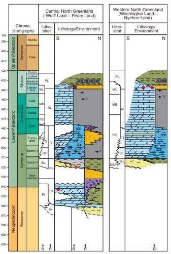
Petroleum seeps and stains are common in the Lower Palaeozoic Franklinian Basin in North Greenland (Chri-stiansen 1989; Christiansen et al. 1989b). Examples have been reported from Washington Land in the west to Peary Land in the east (Figs 2, 3), with records from more than 40 localities. The petroleum seeps and stains occur mainly as three types in distinct geological settings (Fig. 1):
1. Solid bitumen and intense staining or impregnation of carbonates or sandstones closely associated with matur to postmature Cambrian source rocks from the Henson Gletscher Formation in southern Freuchen Land and westernmost Peary Land (Christiansen et al. 1987, 1989b). All examples suggest a maximum vertical migration from the source rock of only a few hundred metres. The organic geochemical composition and measured reflectance of the bitumen samples are in accordance with the regional thermal maturity of the source rock (Christiansen et al. 1987, 1989a; Christiansen 1988).
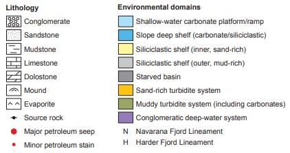
Fig. 1. Stratigraphy of North Greenland (Franklinian Basin) with simplified relations between petroleum seeps, stains and petroleum systems elements (modified from Christiansen 1989 and Hopper & Ineson in press). AL: Amundsen Land Group. BF: Brønlund Fjord Group. Bu: Buen Formation. DB/H: Dallas Bugt and Humbolt Formations. MB: Morris Bugt Group. Pa: Paradisfjeld Group. Pf: Portfjeld Formation. PL: Peary Land Group. Po: Polkorridoren Group. RG: Ryder Gletscher Group. Sk: Skagen Group. Tl: Tavsens Iskappe Group. V: Vølvedal Group. WL: Washington Land Group.
2. Soft to solid bitumen closely associated with mature to postmature Silurian source rocks in either the Lafayette Bugt Formation or the Thors Fjord Member of the Wulff Land Formation. Such bitumen occur-rences are widely distributed throughout North Greenland from Washington Landin the west to Peary Land in the east (Christiansen & Nøhr-Hansen 1989; Christiansen et al. 1989b; Stemmerik et al. 1997). All examples suggest a maximum vertical migration from the source rock of only a few hundred metres. The organic geochemical composition and measured reflectance of the bitumen are in accordance with the regional thermal maturity of the source rock (Christiansen 1988; Christiansen et al. 1989a).
3. Petroleum seepage and stains in immature Cambrian or Ordovician strata, especially from the Portfjeld and Buen formations, in the southern part of Warming Land and Wulff Land but possibly also further to the east and west. These examples of migrated oil are all supposed to be the result of long-distance migration from a yet unknown mature Lower Palaeozoic source rock (Christiansen et al. 1989b).
In addition to the many such examples described and published by Christiansen et al. (1989b), a number of samples have been collected later in western and central Peary Land (unanalysed or unreported), especially black carbonates and solid bitumens in the Henson Gletscher Formation (c. type 1) and also petroleum stains from older sandstones (c. type 3), and solid bitumens from Silurian carbonate of the Samuelsen Høj Formation (c. type 2). Furthermore, several carbonate build-ups with pore spaces filled with bitumen have been found in southern Pentamerus Bjerge and southwards to Kap Jefferson, Washington Land, documented as part of the Kane project (Dawes et al. 2000). Samples are still to be analysed, but most likely the bitumen is closely related to Silurian source rocks (c. type 2). During the ARK-XXV/3 cruise with Polarstern in 2010, geologists from the Fed-eral Institute for Geosciences and Natural Resources (BGR), Germany, sampled and subsequently carried out microscopy analysis of bituminous limestones from the Lafayette Bugt area (Kus & Pletsch 2012).
Petroleum seeps and stains are rare in the Upper Palaeozoic – Cenozoic Wandel Sea Basin (Fig. 2). This is probably because the organic content of most sedimentary units is low, as only proximal facies crop out. Further more, regional thermal maturity is either very low (immature with respect to oil generation) or locally very high (postmature related to low metamorphic conditions in some thrust-sheets). A few examples of petroleum stains and solid bitumen have been reported from cores in the Triassic Dunken Formation (Dunken-2 borehole) and the Upper Permian Midnatsfjeld Formation (Kim Fjelde-1 borehole) in eastern Peary Land. Both occurrences are found in relatively lean mudstone successions with occasional richer intervals. Based on their biological marker signatures, the stains are con-sidered in-situ and intraformational, being generated directly from the rocks in which they are hosted (J.A. Bojesen-Koefoed unpublished data 2013).
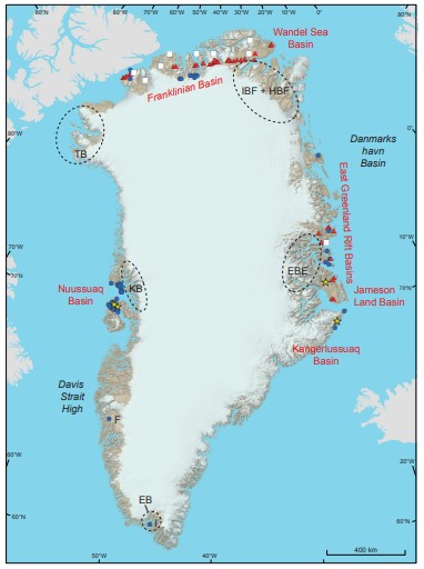
Fig. 2 Map of Greenland showing distribution of petroleum steeps and stains. Red triangles: Petroleum seepage and stains associated with source rock. Blue circles: Petroleum seeps and stains, migrated. White squares: Solid bitumen associated with mineral occurrences. Yellow stars: Gas seepage and gas-rich springs. Red text: Basins with petroleum seeps or stains including Nuussuaq Basin, Franklinian Basin, Wandel Sea Basin, East Greenland rift basins, Jameson Land Basin and Kangerlussuaq Basin. Dotted black lines: Outline of Proterozoic basins or their main outcrop area without petroleum seeps and stains. EB: Eriksfjord basin. KB: Karrat basin. TB: Thule Basin. IBF: Independence Fjord Basin. HFB: Hagen Fjord Basin. EBB: Eleonora Bay Basin. F: Fossilik. I: Ilímaussaq.
Gas
Gas seeps have not been recorded from North Green-land, and gas was not recorded during core drilling of 13 holes in 1985 (Christiansen et al. 1986). From this core drilling, it is known that near surface temperatures are –11 to –14°C, indicating that permafrost in this region is many hundreds of metres thick forming a thick secondary seal, if shallow gas is present. Only a few pingos are known this far north (Bennike 1998). Gas occurrences have not been systematically examined in relation to oil seeps (i.e. in the form of gas inclusions).
Bitumen associated with mineral occurrences
Solid bitumen has been found associated with several mineral occurrences in North Greenland (Fig. 2). One example is a Pb-Zn occurrence in the Navarana Fjord region (east of Freuchen Land, Fig. 3) that has been described in detail by Jakobsen & Steenfelt (1985) and Jakobsen & Omoto (1993). Bitumen is associated with several stages of the mineralisation that formed from hot (200°C) metal-bearing brines that migrated through veins and fractures. Sulphur isotope analysis suggests that the bitumen correlates with the same source rocks that have generated the long-distance migrated oils in southern Warming and Wulff Land (i.e. a c. type 3; Jakob-sen & Omoto 1993).
Solid pyrobitumen has also been recorded in other mineral occurrences such as the Citronen Fjord deposit, Peary Land (Van der Stijl & Mosher 1998) and in association with Zn–Pb–Ag occurrences on Washington Land. Here, it is found in the Ordovician succession close to Petermann Gletscher in the east and in the Silurian succession at Kap Schuchert in the west (Jensen 1998). According to von Guttenberg & van der Stijl (1993), bitumen has also been noted in Zn–Pb mineral occurrences in different settings, including Silurian reefs at Kayser Bjerg, Hall Land, in Cambrian carbonate debris flows at Hand Bugt, northern Nyeboe Land and at Kap Wohlge-muth, northern Nares Land (Fig. 3).
Fig. 3 Close up examples from the web-based GIS model, in this case with a topographic map as background. Franklinian Basin, North Greenland encompassing: Wulff Land – Nares Land – Freuchen Land region.
Based on the examples of mineral occurrences associated with solid bitumen in North Greenland, there seems to be a strong correlation between mineral and petroleum systems. Some systems are clearly associated with organic-rich Silurian mudstones (c. type 2). Others are related to organic-rich, thermally postmature, deep-water deposits of Cambrian or Ordovician age (c. type 3) in strongly folded or steeply dipping zones in the northern part of the Franklinian Basin. These occurrences are both of MVT and SEDEX types.
Data source: Inventory of onshore petroleum seeps and stains in Greenland: a web-based GIS model. Flemming G. Christiansen, Jørgen A. Bojesen-Koefoed. 2021: GEUS Bulletin 47. 651
Следующий Бассейн: Labrador Shelf