Тип бассейна:
Подтип бассейна:
Класс бассейна:
Возраст бассейна:
Тип полезных ископаемых:
Геологический возраст начало:
Геологический возраст конец:
Площадь: 758839.75 км²
Maranon Basin
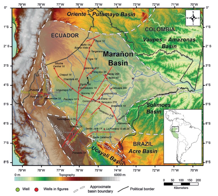
The Marañón Basin is part of a much larger subAndean basin, which extends north of the Ucayali and Acre Basins, and extends into Ecuador and Colombia, where it is known as the Oriente and Putumayo Basins, respectively (Figure 1). The Marañón Basin is bounded to the south by the Contaya Arch, to the east by the Vaupes-Amazonas and Solimões Basins, and to the west by the Andean Cordillera (Figure 1). The basin has an area of approximately 320,000 km2 (123,550 mi2) and is represented by a Mesozoic–Cenozoic sedimentary succession up to 7000 m (23,000 ft) thick (Figure 2).
Figure 1. The Marañón Basin is located in the northern part of Peru. Its boundary with the Oriente and Putumayo Basins is unclear; however, they share most of the tectonic evolution. The Huallaga and Santiago Basins to the east were part of the early Marañón Basin but disconnected later during Andean deformation. 6000 m (19,685 ft).
In 2016, the Marañón Basin accounted for about ~4% of the total hydrocarbon production in Peru, but in terms of oil it represents ~14% (~2 million bbl) of Peruvian oil production (PERUPETRO, 2016). More than 50,000 km (31,000 mi) of reflection seismic data have been acquired, and more than 600 exploration and development wells have been drilled since the beginning of exploration in the early 20th century. This means an exploratory well every ~550 km2 (210 mi2) suggesting that the basin is fairly unexplored.
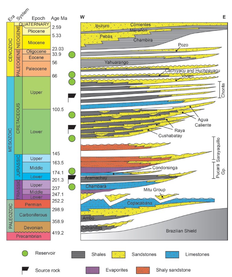
Figure 2. The Mesozoic and Cenozoic stratigraphy of the Marañón Basin consists of up to 7000 m (23,000 ft) of clastic and marine strata. The older sediments were deposited in a series of extensional depocenters bounded by normal faults. From the Late Jurassic to the Late Cretaceous, the basin was controlled by eustatic processes. The Cenozoic stratigraphy is mainly related to the onset of Andean deformation.
Even though the basin has an ancestral history (Tankard et al., 1995; Jaillard et al., 2000), the tectonic and stratigraphic evolution of the present Marañón Basin began in the Late Permian–Early Triassic as a consequence of an extensional episode that affected western Gondwana (Tankard et al., 1995; Jaillard et al., 2000; Sempere et al., 2002; Spikings et al., 2016). This extensional tectonic event created north-northwest-oriented extensional faults that controlled the structural framework of the basin and the subsequent tectonic evolution. Several marine transgressive and regressive cycles facilitated the accumulation of several oil-prone source rock intervals and Cretaceous reservoirs. This, together with the discovery of large oil fields, triggered exploration activities and studies focused on the Marañón Basin. Among others, Mathalone and Montoya (1995) presented an integrated review of the petroleum geology of the sub-Andean basins of Peru. Díaz Palacios (2002) used outcrop and subsurface data to address the paleogeography of the Pucará Group, and Fernández Castañeda et al. (2002) analyzed its potential as a hydrocarbon play fairway. Wine et al. (2002a, b) carried out regional integrated studies of the Marañón, Huallaga, and Santiago Basins to evaluate their exploration potential. There is also a large data set of unpublished reports from the companies that have worked in the area, although many are difficult to access. The aim of this chapter is to address for the first time the importance of the Permian– Triassic extension in the basin, and the role that these structures have had in the structural evolution and stratigraphic framework of the Marañón Basin during the Mesozoic–Cenozoic.
GEOLOGICAL SETTING
The central Andean region preserves a Phanerozoic history of basin formation, where Neoproterozoic tectonism provided the anisotropies that subsequently controlled most of the Phanerozoic basins developed in South America (Tankard et al., 1995; Jaillard et al., 2000; Ramos, 2008, 2018). The Marañón Basin records at least 250 m.y. of basin subsidence since the Mesozoic, accumulating a sedimentary sequence up to 7000 m (23,000 ft) thick. There are four well-recognized stages of basin evolution: (1) Permian–Triassic extension characterized by “molasses” and volcanoclastic deposits; (2) Jurassic thermal subsidence, reflected in a marine transgression and deposition of the Aramachay source rock. Marine regression in the late Middle–Upper Jurassic is also responsible for the deposition of continental deposits in the eastern part of the basin and shallow marine-sabkha strata in the western part; (3) a Neocomian angular unconformity overlying by Cretaceous fluvial to marginal clastic and marine deposition controlled primarily by eustatic changes. Late Cretaceous–Oligocene minor structural inversion also occurred although no major unconformities are recorded, suggesting a long period of tectonic quiescence; and (4) Neogene compression and structural inversion generated the Andean foldand-thrust belt toward the western margin, which subsequently disconnected the present Huallaga and Santiago subbasins from the present Marañón Basin. Coevally, the eastern part of the basin became the current foreland basin depozone of the Andean system, which is characterized by structures related to structural reactivation of older normal faults in a reverse sense.
The main tectonic elements comprising the morphostructural architecture of the basin are summarized in Figure 3. The most conspicuous inversion structures are (1) the Iquitos Arch, which is considered the present-day forebulge of the northwestern Amazonian foreland basin (Roddaz et al., 2005a) and (2) the Contaya Arch, an ancient west-northwest– east-southeast-oriented feature that represents the southern limit of the Marañón Basin (Figure 3).
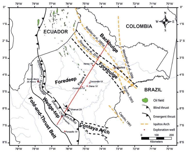
Figure 3. Map showing the main tectonic elements and largest hydrocarbon fields in the Marañón Basin.
The dominant structural style in the foreland part of the basin is structural inversion of Permian–Triassic normal faults (Figure 4), associated with the largest oil accumulations. The Huallaga and Santiago subbasins constitute the wedge-top depozone of the basin and are characterized by halokinetic structures and a thinskinned fold-and-thrust belt detached in the lower Mesozoic evaporites superimposed on thick-skinned structures (Figure 4). According to thermocronological data, the deformation of the wedge-top depozone (sub-Andean zone) and the propagation of the thrusting wedge began between 30 and 24 Ma (Alemán and Marksteiner, 1993; Eude et al., 2015). The Marañón Basin, as it is known today, constitutes the foreland basin depozone of the Andean Cordillera with the thickest Cenozoic section (Figure 4).
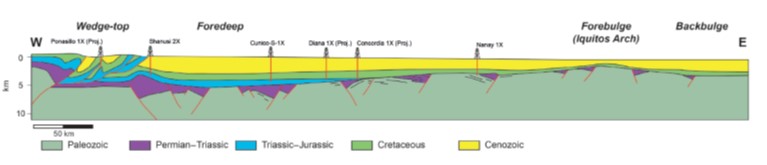
Figure 4. A regional cross section along the Marañón Basin shows the wedge-top depozone, represented by the Huallaga and Santiago Basins in the western margin, the foreland basin in the central region where the thickest sedimentary section is recorded, and the Iquitos forebulge in the eastern margin.
PALEOZOIC-“THE BASEMENT”
This cycle is represented by the Paleozoic sequences above the Precambrian basement beneath the Eastern Cordillera to the west and the Brazilian shield to the east. The oldest known Paleozoic rocks are the Ordovician outcrops in the Contaya Arch (Figure 1). Seismic sections across the basin reveal the presence of a thick stratified sequence structured by normal faults (Figure 5), which should represent the northern extension of the productive Paleozoic sequences of the Ucayali and Madre de Dios Basins (Mathalone and Montoya, 1995; Jaillard et al., 2000). Only a few exploration wells (Tapiche, Palmera, La Frontera Yarina) in the eastern part of the basin have reached this basement (Figure 1), which is composed of magmatic and metamorphic rocks. These wells also confirmed the presence of Devonian, Carboniferous, and Permian sections below the Mesozoic section of the Marañón Basin. The lack of data for these sequences within the Marañón Basin makes it very difficult to evaluate their hydrocarbon potential.
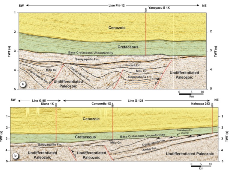
Figure 5. Composite seismic line through the central part of the Marañón Basin. The lower and middle Paleozoic sequences are represented by parallel seismic reflectors tilted toward the northeast due to an extensive extensional event during the Triassic. Unconformities are clearly observed at the base and top of the Mitu Group. The widespread “Base Cretaceous Unconformity” marks a first order change in the basin tectonic setting associated with the Jurua orogeny.
LATE PERMIAN–JURASSIC SUBSIDENCE
Permian-Triassic (Early Rifting)
A change in plate velocities produced a generalized, early disassembly of western Pangea along South America (e.g., Tankard et al., 1995; Jaillard et al., 2000). In northern Peru, this event generated continental rifted basins filled with Permian–Triassic igneous and sedimentary rocks of the Mitu Group (Jaillard et al., 2000; Sempere et al., 2002; Figure 2). These sequences are well exposed along a northwest– southeast axis in the Eastern Cordillera (Sempere et al., 2002). According to these authors, the earliest episode of rifting in northern Peru is late Permian in age and was propagated diachronically southward into south Peru and Bolivia. Recent U-Pb ages (Miškovic´ et al., 2009; Spikings et al., 2016) constrain the age of the Mitu Group to between ~245–240 and ~220 m.y (Anisian–Norian), proposing a Middle–Late Triassic age for this extensional event in southern Peru.
This rifting event is well recognized in the Marañón Basin as a series of basement-involved normal faults that bound a suite of discrete half grabens (Figures 5, 6). Stewart et al. (2018) using a large data set of gravity and magnetic data recognize the presence of a major Pre-Cretaceous depocenter extending northward from the central Marañón Basin toward the Iquitos Arch. No wells have penetrated the Mitu Group in the Marañón Basin, but the outcrops in the Eastern Cordillera indicate that these basins were filled with alluvial fans and fluvial depositional systems consisting of thick accumulations of coarse-grained “molass-style” sediments, comprising conglomerates, sandstones, and mudstones, with local carbonates, evaporates, and volcaniclastic materials (Benavides, 1968; Kontak et al., 1985; Sempere et al., 1999, 2002; Spikings et al., 2016). Seismic interpretation shows that these Mitu strata underlie the deepest parts of the central and western Marañón Basin.
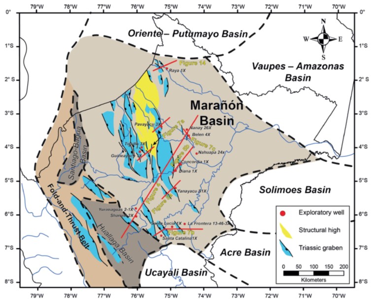
Figure 6. Structural map of the early Marañón Basin. Pervasive extension in the western margin of Gondwana is recorded in the Marañón Basin as north-northwest–south-southeast-oriented structural lows and highs, which controlled the initial sedimentary infill of the basin during the deposition of the Mitu Group.
Late Triassic–Lower Jurassic (Postrift Stratigraphy)
From the Upper Triassic onward, the fault-related subsidence that controlled deposition of the Mitu Group gradually decreased through most of the Marañón Basin. The postrift sag subsidence amalgamated the previous Permian–Triassic extensional depocenters into a single, broad shallow marine basin (Figures 5, 7). The postrift Pucará Group, originally described by Harrison (1943) and named by Mégard (1968), infilled this basin with shallow to deep marine deposits (Díaz Palacios, 2002; Rosas et al., 2007). Toward the east, fluvial and deltaic clastic systems have been drilled by the deepest wells in the Marañón Basin, defining the eastern limit of the basin. The Pucará Group is divided into three formations, comprising lower and upper carbonate platforms (Chambará and Condorsinga Formations), with an intermediate phase of basin deepening and sediment starvation, which generated a regional, organic-rich argillaceous drape (Aramachay Formation; Rosas et al., 2007). Wotzlaw et al. (2014), using bivalve biochronology and high-precision zircon U-Pb geochronology for volcanic ash beds within the Aramachay Formation, constrain the age to uppermost Norian, perhaps ranging into the earliest Rhaetian. Facies analysis in central and north Peru (Loughman and Hallam, 1982) suggests a tectonically quiescent continental margin with unrestricted access to the paleo-Pacific Ocean.
Díaz Palacios (2002), using published field observations and well data from the Marañón Basin, reconstructed the paleogeography of the Pucará Group (Figure 8). He described the onset of sedimentation as a shallow marine transgressive sequence (Chambará Formation), during which local structural highs remained active and controlled the sedimentation. An increase in subsidence during the uppermost Norian– Rhaetian favored the deposition of bituminous limestones and shales of the Aramachay Formation (Rosas et al., 2007). Overlying this formation is the regressive sequence of the Condorsinga Formation that formed a well-developed carbonate platform (Rosas et al., 2007). Erlich et al. (2018a) carried out a complete revision of the depositional environments and geochemistry of the Pucará Group.
The Pucará Group has been traditionally considered to underlie the Marañón Basin, in most cases as remnants due to erosion (Wine et al., 2002a, b). Recently, its presence has been subject to debate due to the lack of biostratigraphic data in wells. Calderón et al. (2017a), using long-distance correlation, propose that this sequence is Paleozoic, but they do not present biostratigraphy to support this interpretation. In contrast, our seismic interpretation shows that this sequence overlies the deposits of the Mitu Group, and in most cases is infilling and burying the topography related with the Permian–Triassic grabens (Figures 7a, c). It constitutes the first regional deposition that covered most of the Marañón Basin. Therefore, we consider this sequence as the Pucará Group. In addition, U-Pb dating from detrital zircons confirms the presence of Pucará Group rocks in the Ucayali Basin and the southern part of the Marañón Basin (Erlich et al., 2018b).
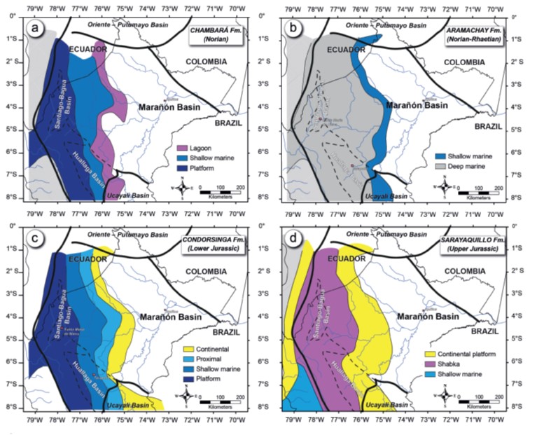
Figure 7. Facies distribution maps for Pucará Group and the Sarayaquillo modified from Díaz Palacios (2002). a. Chambará Formation, b. Aramachay Formation, c. Condorsinga Formation, and d. Sarayaquillo Formation.
Jurassic Regression (Sarayaquillo Formation)
The end of Pucará Group sedimentation coincides with the cessation of marine influx and beginning of continental deposition. Deposition of clastic sediments and evaporites marks the transition to the Sarayaquillo Formation (Figure 2). The basal section of this unit (also known as Chaypaya Formation; Fernández Castañeda et al., 2002) consists of a supratidal sabkha environment characterized by precipitation of evaporites interbedded with dolostones, limestones, mudstones, and sandstones, which are also recognized in outcrops in the Santiago and Huallaga subbasins (Fernández Castañeda et al., 2002; Wine et al., 2002a). The development of fluvial and shallow marine facies marks the shift upward and laterally to a suite of continental red beds (sandstones, conglomerates) that blanketed the evaporitic section and the Pucará Group (Figure 8d; Mathalone and Montoya, 1995; Wine et al., 2002a, b). U-Pb zircon analyses show a sediment provenance area predominantly from the western part (Erlich et al., 2018b).
Major plate reorganization occurred at the end of the Jurassic triggering a deformation event, which promoted positive inversion of the previous normal faults and half grabens (Jaillard et al., 2000). These deformational effects extend from the Solimões Basin (Brazil) to the Peruvian Eastern range (Barros and Carneiro, 1991; Rosas et al., 2007; Caputo, 2014). This tectonic event, known previously as the Nevadan orogeny, has been renamed as Jurua orogeny by Caputo (2014) for its correlation with the strong diastrophism in the Juruá River in the nearby Solimões Basin, assigning a late Kimmeridgian age. In the Marañón Basin this event is reflected in the form of widespread regional uplifts, structural inversions, and block tilting beneath a pronounced regional parallel or angular unconformity of latest Jurassic early Cretaceous age, known as the “Base Cretaceous Unconformity.” This unconformity, widespread along the entire basin, marks a first-order sequence boundary above the Upper Jurassic Sarayaquillo Formation and equivalent formations, as well as above older units. This tectonic event also caused a major change in the provenance areas that shifted from local western sources to proximal western Amazonian cratonic sediment sources (Erlich et al., 2018b).
CRETACEOUS SEDIMENTATION AND TECTONIC INVERSION (CUSHABATAY, RAYA, AGUA CALIENTE, CHONTA, VIVIAN, AND CACHIYACU FORMATIONS)
Because most of the wells have penetrated the Cretaceous, this sequence has been studied in great detail by geoscientists in both independent oil companies and PERUPETRO (e.g., Jaillard et al., 1995, Wine et al., 2002b; Figures 2, 9).
The Cretaceous successions of the Marañón Basin and the related Oriente and Putumayo Basins were deposited in a tectonic setting, which ranged from a passive margin in the Oriente and Putumayo Basins (eastern Ecuador and Colombia) to a retro-arc setting in northeastern Peru (Mathalone and Montoya, 1995; Valasek et al., 1996; Jaillard et al., 2000). A long period of tectonic subsidence related to tectonic episodes and eustatic processes during the Cretaceous permitted the growth of a westward-thickening wedge of fluvial and marginal marine clastic deposits (Figure 10; Mathalone and Montoya, 1995; Jaillard et al., 2000).
The major erosional unconformity caused by the vertical movements of the Juruá orogeny is present across the entire basin. This unconformity partially eroded the Sarayaquillo Formation, some of the Triassic early inverted grabens and Paleozoic rocks, and also exhumed the Precambrian basement in the eastern part (Caputo, 2014). Seismic and well data show the Cretaceous overlying a thicker section of the Sarayaquillo Formation toward the western and southern part of the basin (Figures 9, 10a). The eastern margin of the basin is characterized by largescale truncation of the lower Mesozoic and Paleozoic sections, forming a pervasive angular unconformity that locally eroded away the entire Mesozoic section and part of the Paleozoic (Figures 9). Well correlations indicate that the unconformity is widespread not only within the basin but also throughout the Peruvian sub-Andes (Mathalone and Montoya, 1995).
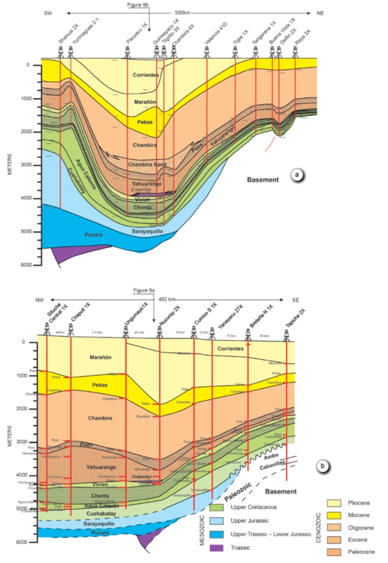
Figure 8. Well correlations along the Marañón Basin, location in Figure 1. a. Southwest northeast correlation shows the thickest Mesozoic section toward the western part of the basin, whereas the thickest Cenozoic section in the central part of the basin coincides with the present foredeep depozone. b. Northwest–southeast correlation along the central part of the basin shows a quite homogeneous thickness for the entire sedimentary sequence. Near the southeastern margin of the basin, uplift of the basin related to the Jurua orogeny favored the erosion of the complete Jurassic and Triassic sequences and the Cretaceous is overlying the Paleozoic section.
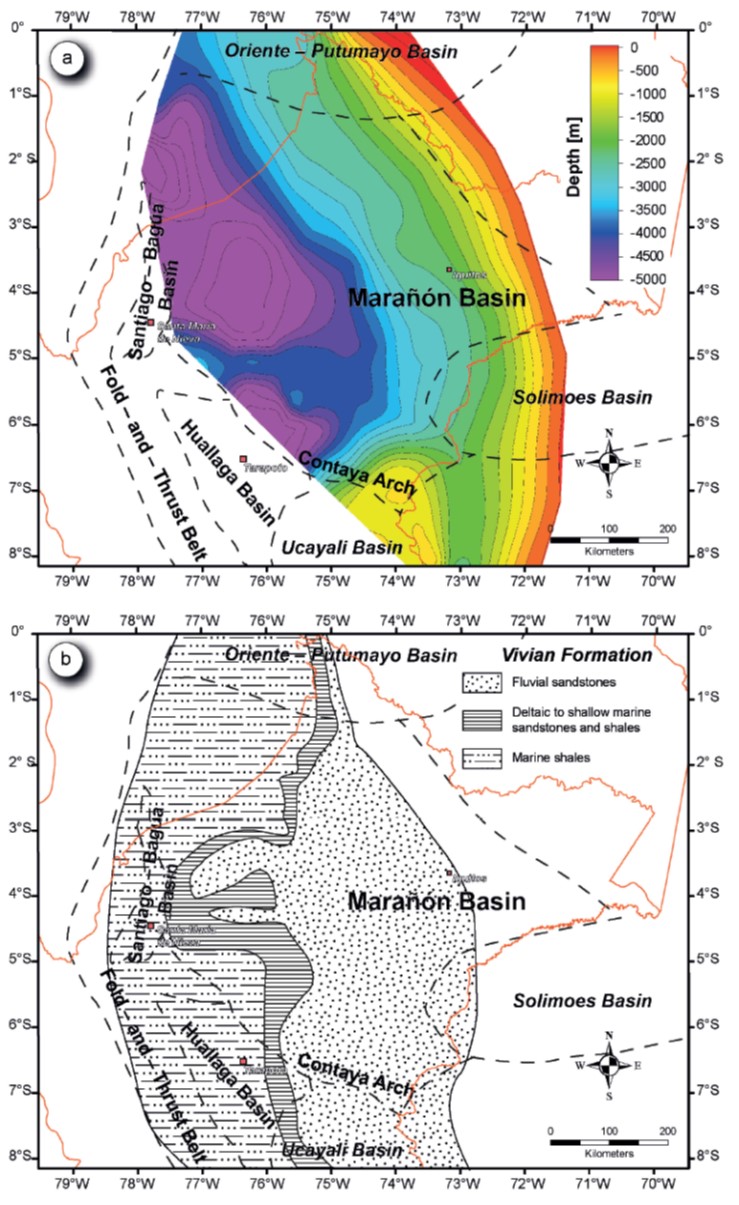
Figure 9. a. Map with depth to base Cretaceous modified from Mathalone and Montoya (1995) and Calderón et al. (2017a). b. Regional facies distribution for the Vivian Formation, which constitutes one of the main reservoirs in the basin.
The Jurua orogeny reactivated the eastern provenance areas and resulted in the deposition of the sandstones of the Cushabatay Formation. Detrital zircon geochronology suggests that the sediments have multiple sources (Erlich et al., 2018b). More than 400 m (1310 ft) of detrital rocks (sandstones and shales) of the Cushabatay Formation were deposited in fluvial to shoreface environments in the western part of the basin (present Santiago Basin), whereas the sediment thickness decreases toward the east, where exploratory wells in the central part of the basin found only 100 m (328 ft), and just a few meters in the easternmost part of the basin (Figure 9a). This sedimentation cycle persisted until the Albian, when a major transgressive event deposited the calcareous green shales, interlayered with sands and platform limestones of the Raya Formation (Figure 2; Napo Basal in the Oriente Basin in Ecuador).
The subsequent Albian to early Cenomanian regressive cycle deposited the Agua Caliente Formation, comprising both fluvio-deltaic and marine sandstones and shales. Toward the west, in the Santiago and Huallaga Basins, this formation is more shale prone, comprising marine facies, which are gradational into the Chonta Formation (Wine et al., 2002a). Tectonic quiescence characterizes the basin from upper Cenomanian time onward, resulting in a renewed marine transgression resulting in a change from the deltaic deposition characteristic of the Agua Caliente Formation to the deposition of the platform sediments of the Chonta Formation. This formation is punctuated by subtle unconformities, defining the stacking of at least three transgressive–regressive sequences that reflect the intermittent eustatic processes that characterize this period (Jaillard et al., 1995; Figure 2). The basal section corresponds to the first transgression consisting of sandstones, limestones, and shales representing a deltaic and a carbonate platform. The main depocenter was located in the east, where up to 1200 m (~4000 ft) of shales were deposited. Maximum flooding occurred during the Turonian as suggested by limestones and black shales forming the middle section of the Chonta Formation. According to Jaillard et al. (1995), the absence of some biozones of the upper Turonian toward the eastern part of the basin may indicate a break in sedimentation or erosion related to a subtle tectonic inversion during the upper Turonian as the Coniacian transgressive event is preserved. Two more transgressive–regressive sequences in the Coniacian and Santonian deposited the upper section of the Chonta Formation, characterized by marine shales interfingered with sandstones and limestones toward the top.
Between the middle Campanian and late Maastrichtian, two transgressive–regressive cycles deposited the Vivian Formation, which constitutes the main hydrocarbon reservoir of the Marañón Basin and comprises two genetic sequences in the east but only one to the west (Valasek et al., 1996). Overall the Vivian Formation is characterized by a clastic sequence that evolves from fluvial sandstones, which covered most of the central part of the Marañón Basin to deltaic sandstones and marine shales toward the east (Figure 10b). Lopez-Gamundi and Lopez-Gamundi (2018) show that these sandstones present a simple linear trend of decreasing porosity with depth, indicating that overburden stress is the dominant factor controlling porosity reduction for the main reservoir of the Marañón Basin.
This Cretaceous cycle ends with a last transgression in the late Maastrichtian(?) with the deposition of the marine shales, mudstones, limestones, and sandstones of the Cachiyacu Formation, which is in turn overlain by Cenozoic continental shales and siltstones of the Huchpayacu Formation.
CENOZOIC SEDIMENTATION AND COMPRESSION: DEVELOPMENT OF THE SUB-ANDEAN FORELAND BASIN
From Late Cretaceous and throughout the Cenozoic, tectonic loading of the Andes from Colombia to northern Bolivia developed the Amazonian foreland basin system. Roddaz et al. (2010) described the basin infill of this large foreland basin system and proposed a Cenozoic sedimentary model for the entire Amazonian basin in terms of foreland systems.
The Cenozoic section is extensively exposed in the sub-Andean zone (Hermoza et al., 2005), where it consists of more than 4000 m (13,000 ft) of fluvial, tidal, and marine sediments (e.g., Hermoza et al., 2005; Hovikoski et al., 2010; Roddaz et al., 2010). In the Marañón foreland basin, this same sequence has been penetrated by all the wells, showing thicknesses that vary from more than 4000 m (13,000 ft) in the foredeep depozone to about 2000 m (6500 ft) in the eastern part (Figures 9).
Cenozoic sedimentation in the Marañón Basin began in the Paleocene, as recorded by floodplain and lacustrine continental deposits of the Yahuarango Formation (Kummel, 1948; Díaz et al., 1998; Sánchez and Herrera, 1998). Roddaz et al. (2010) suggested that this sequence was deposited in a backbulge or distal foredeep in response to tectonic loading of the proto-Andean Cordillera. Stratigraphic isopach map of the Yahuarango Formation (Figure 10) documents the occurrence of a gentle sedimentary wedge thickening to the west up to more than 1800 m (5900 ft) in front of the Santiago Basin.
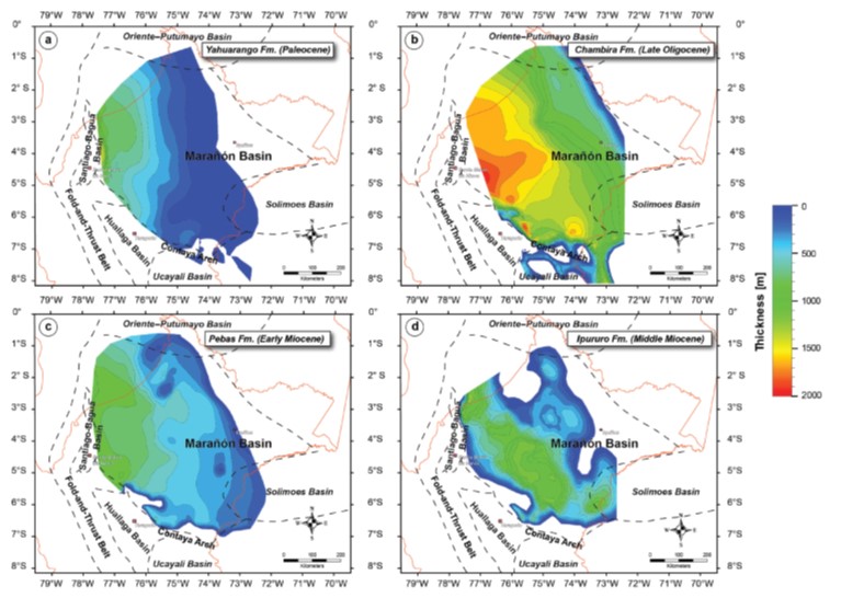
Figure 10. Cenozoic gross isopach maps for the main Cenozoic formations. a. Yahuarango Formation, b. Chambira Formation, c. Pebas Formation, d. Ipururo Formation.
The middle Eocene–Oligocene Pozo Formation (Williams, 1949; Seminario and Guizado, 1976; Hermoza et al., 2005) overlies a major regional unconformity extending from northern Peru to Ecuador and Colombia defining a tectonic unloading event due to the erosion of the Western Cordillera (Christophoul et al., 2002; Roddaz et al., 2010). The Pozo Formation has been divided into a lower sequence consisting of tide-influenced deltaic and estuarine conglomerates and sandstones whose thickness varies from 20 m (65 ft) in the sub-Andean region to up to 60 m (197 ft) in the foredeep depozone (Hermoza et al., 2005; Roddaz et al., 2010). The upper sequence comprises an intercalation of shales, sandstones, and shallow marine limestones, which were deposited in a shallow shelf environment during regressive and transgressive episodes (Hermoza, 2004). Its thickness ranges from 50 m (164 ft) to 150 m (490 ft).
A generalized tectonic loading stage from the west, associated with the emplacement of the Andean Cordillera during the Neogene, resulted in the tidally influenced and fluvial channel sedimentation characteristic of the Chambira and Pebas Formations and finally the purely continental Ipururo Formation (Hermoza et al., 2005). Stratigraphic isopach maps (Figure 11) show migration of the main depocenter from west (Chambira and Pebas Formations) to the east (Ipururo Formation), which constitutes the present foredeep depozone. The Pliocene-Pleistocene sequence is represented principally by sandstones of the Marañón and Corrientes Formations with a combined thickness varying from 600 m (1970 ft) to 1500 m (4920 ft). These strata are interpreted as the deposits of meandering and flood plain fluvial systems, probably similar to the present depositional system of the Amazonian rivers (Hermoza, 2004). Roddaz et al. (2005b) based on sediment provenance studies and river drainage analysis concluded that the composition of Neogene terrigenous sediments indicates provenance areas in both the Brazilian Craton and the Andean Cordillera. According to these authors, most of the basic detritus in the upper section came from the erosion of the Ecuadorian foredeep depozone.
Neogene compression generated a well-developed fold-and-thrust belt to the west in the Santiago and Huallaga Basins, which constitutes the present wedgetop depozone of the Marañón foreland basin. The compressional episode also caused structural inversion of preexisting normal faults in the foredeep depozone (Figure 6), together with the development of the Iquitos forebulge toward the eastern part of the basin (Figure 3).
PETROLEUM SYSTEM
The architecture, subsidence, and major eustatic changes in the Marañón Basin are favorable for the development of the elements of an active petroleum system. The Upper Triassic–Lower Jurassic Aramachay Formation of the Pucará Group and the Upper Cretaceous Raya and Chonta Formations are the main source rocks in the basin (Wine et al., 2002a, b; Tocco and Hermoza, 2009; Erlich et al., 2018a). The Paleozoic is poorly known in the Marañón Basin, but it may also have potential as it is the productive sequence further south (Mathalone and Montoya, 1995). Calderón et al. (2017a, 2017b) suggested that the Paleozoic Shinai Formation might be present and therefore considered as a potential source rock in the Huallaga Basin. The regressive sandstones of the Agua Caliente and Vivian Formations constitute the main reservoirs, and sandstones in Cushabatay, Chonta, and Pozo Formations could constitute also productive reservoirs.
Even though no oil accumulations have been discovered in the wedge-top depozone, oil and gas seeps occur in the Huallaga and Santiago basins (Wine et al., 2002a, b). Erlich et al. (2018a), using geochemical and biomarker data from rock extracts and oil seeps from the Aramachay Formation in the Huallaga Basin, demonstrate correlation with Jurassic oils described from the Marañón and northwestern Ucayali Basins. They concluded that generation and expulsion of hydrocarbons began in the Early Cretaceous and migrated from west to east since the Late Cretaceous until the present. Two-dimensional basin modeling by Calderón et al. (2017b) in the Huallaga Basin and the foredeep depozone of the Marañón Basin indicate that the oldest structures (Paleocene–early Miocene) trapped hydrocarbons, and the subthrust traps in the Huallaga Basin are the most prospective plays.
In the foredeep and forebulge depozones of the Marañón Basin, the main oil-prone source rocks are the Chonta and Raya Formations with Total Organic Carbon (TOC) average exceeding 3% (Mathalone and Montoya, 1995; Martínez and Erquiaga, 2003; Tocco and Hermoza, 2009). Toward the Ucayali Basin, these formations are coarse-grained terrestrial deposits with little source rock potential (Mathalone and Montoya, 1995), whereas in the Huallaga Basin, they generally lack sufficient total organic content (TOC) to be effective source rocks for oil (Erlich et al., 2018a). Martínez and Erquiaga (2003) identified two oil families that correspond with facies variation within the Chonta Formation: one more shaly, mainly in the Marañón Basin, and one more calcareous, which is better developed in the Oriente Basin of Ecuador. The Upper Cretaceous Chonta Formation source rock is responsible for most of the oil accumulations in the northeastern part of the Marañón Basin (Figure 3; Tocco and Hermoza, 2009). In addition, biomarkers indicate that some oils from the southeastern part of the basin can be correlated with a Jurassic source rock (Tocco and Hermoza, 2009; Erlich et al., 2018a), the Aramachay Formation being the most suitable candidate for the origin of these oils.
In terms of preservation, Martínez and Erquiaga (2003) identified four processes affecting oil preservation in the two principal reservoir rocks (Vivian and Chonta Formations) of the Marañón Basin: (1) biodegradation, (2) cracking, (3) water flushing, and (4) leaking. These degradation processes affected with different intensity, the Chonta Formation being less susceptible to presenting degraded oils.
Data source:Zamora, Gonzalo, and Willy Gil, 2018, The Marañón Basin: Tectonic evolution and paleogeography, in G. Zamora, K. R. McClay, and V. A. Ramos, eds., Petroleum basins and hydrocarbon potential of the Andes of Peru and Bolivia: AAPG Memoir 117, p. 121–144
Следующий Бассейн: Takutu Graben