Тип бассейна:
Подтип бассейна:
Класс бассейна:
Возраст бассейна:
Тип полезных ископаемых:
Геологический возраст начало:
Геологический возраст конец:
Площадь: 183418.81 км²
Orphan Basin
The Orphan Basin, located offshore northeastern Newfoundland, Eastern Canada, is a Mesozoic rift basin formed during the disintegration of Pangaea and the concurrent opening of the North Atlantic Ocean. The majority of previous work has divided the basin into the East (EOB) and West Orphan (WOB) subbasins, separated by the Central Orphan High (COH). These subbasins share some similarities but have different opening kinematics, timings, and sedimentary histories. Despite its critical location at the termination of the Charlie-Gibbs Fracture Zone (CGFZ), and the transition from the main North Atlantic Ocean to the Labrador Sea, the Orphan Basin remains relatively poorly understood compared to other marginal rift basins in the North Atlantic region. Additionally, much of the public domain geoscientific literature on the basin has not undergone peer review (e.g., conference abstracts, industry reports, etc.). As such, the aim of this review is to critically scrutinize and synthesize the wealth of geoscientific information on the basin, present an overview of the complex structure of the basin and its sedimentary fill, identify knowledge gaps, and provide insights for future research directions. This review highlights that significantly more is known about the EOB than the WOB, largely due to data availability. Furthermore, structural inheritance appears to have strongly influenced the evolution and geometry of rift-related faults. Areas requiring further research include refining the timing and relationship between the opening kinematics of the EOB and WOB, particularly pertaining to the role of the Flemish Cap. Additionally, the continuation of sedimentary facies from the better constrained EOB into the WOB is currently poorly understood, especially for the syn-rift strata, which results in substantial exploration risk in the WOB. Understanding the WOB, including the magmatic rocks, is essential for understanding the wider southern North Atlantic region.
The Orphan Basin is one of the largest (over 100,000 km2) underexplored basins on the eastern Canadian margin (Burton-Ferguson et al., 2006). This basin, which is referred to as the East Newfoundland Basin in some literature (e.g., Grant and McAlpine, 1990; Miall and Balkwill, 2019), is located approximately 300–600 km northeast of the island of Newfoundland, at the southern limits of the Labrador Sea (Fig. 1a). Although the Newfoundland margin is one of the most well-studied passive margins globally, the knowledge-base is largely focused on the Grand Banks region to the south of the Orphan Basin. Specifically, most attention has been focused on the Jeanne d'Arc and Flemish Pass basins (e.g., Sinclair et al., 1994), as well as the margin's conjugate relationship with the Iberian margin (Causer et al., 2020; Peace and Welford, 2020; Tucholke et al., 2007), directed largely by petroleum industry activity and interest (e.g., BeicipFranlab et al., 2020).
The Orphan Basin can be subdivided into two subbasins, the East Orphan Basin (EOB) and the West Orphan Basin (WOB), separated by a structural high, referred to as the Central Orphan High (COH) (Dafoe et al., 2017; Enachescu et al., 2005; Gacal-İs̨ler, 2009). The basin is bounded to the west by the Bonavista Fault Zone on the Bonavista Platform (i.e., continental shelf), to the south by the Grand Banks and the Cumberland Belt Transfer Zone, to the east by the Orphan Knoll, Flemish Cap, and the continent ocean boundary, and to the north by the Charlie-Gibbs Fracture Zone (CGFZ) (Fig. 1b). Despite its location at this tectonically significant part of the North Atlantic (Skogseid, 2010), the basin has remained poorly understood compared to other North Atlantic rift basins such as the Flemish Pass, Hatton, Porcupine, and Rockall basins (Baur et al., 2010; Foster and Robinson, 1993; Scotchman et al., 2018; Shannon, 2018; Sinclair et al., 1994).
Geological background
The Orphan Basin is bounded to the north by the Charlie-Gibbs Fracture Zone and its landward extension, the Dover Fault, and to the west by the Bonavista Fault. To the south, the basin joins across the Cumberland Belt Transform Zone with the Jeanne d’Arc and Flemish Pass basins beneath the northeastern Grand Banks. Rifting began at or before the Late Jurassic based on age constraints from deep-water wells (e.g. Blue H-28, Great Barasway F-66 and Lona O-55; Ford & Johnston 2003) and seismic interpretation of Triassic sediments (Chian et al. 2001; Enachescu et al. 2005). A compilation of basement depths (Louden et al. 2004) shows the White Sail Fault (WSF), together with a system of prominent NE–SW trending ridges to its west, divides the basin into a generally shallower eastern, and deeper western, sub-basins (Fig. 1). This difference in basement depths and the role of the WSF in the development of the basin are not well-understood and the deposition of a much thicker Neogene sedimentary layer within the western sub-basin (e.g. at borehole Blue H-28) may alone have caused the asymmetry.
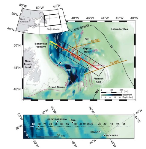
Figure 1. Location of the OBWAVE profile (this paper), coincident MCS profile Or0–122 and previous wide-angle seismic profiles, FLAME (Gerlings et al. 2011), 86-6(8) (Chian et al. 2001) and Line 1 (Keen & Barrett 1981), and selected boreholes (black filled circle with white outline). Inset shows the location of the study area relative to eastern Canada. Background shows the basement depth (Louden et al. 2004) in colour scale and bathymetry with depth contours 100, 500 and 1000 m. Purple lines are faults defined by Enachescu et al. (2005). Black lines are magnetic anomalies and fracture zones. Model distances are in red with labelled numbers. Thick red line is the shot line. Small black filled circles are locations of OBSs. Black rectangle shows detailed area plotted in the lower panel with OBSs numbered in black (white where background is dark). OK, Orphan Knoll; JAB, Jeanne d’Arc Basin; FP, Flemish Pass; BF, Bonavista Fault; WSF, White Sail Fault; MuF, Murre Fault; MeF, Mercury Fault; CBTZ, Cumberland Belt Transform Zone; FZ, Fracture Zone.
A plate reconstruction at the time of magnetic anomaly M0 time (Srivastava & Verhoef 1992; Skogseid 2010) indicates that the western and eastern Orphan basins and Orphan Knoll form a multibasin rift system that is conjugate to another set of structures formed by the Rockall Trough, Porcupine Bank and Porcupine Basin on the Irish side of the Atlantic. This suggests that early rifting and basin development prior to crustal breakup and the onset of seafloor spreading was complex. The earlier pre-rift position of Flemish Cap is more speculative, but an anticlockwise rotation of this rift-resistant block back into the Orphan Basin has been proposed to avoid an overlap between Flemish Cap and Galicia Bank, while closing the Newfoundland Basin-Iberia gap at pre-M0 times (Sibuet et al. 2007). Such an interpretation suggests that the northwestern Flemish Cap and the Bonavista Platform are conjugate sides of the basin.
Rifting within the Orphan Basin has been described using a large set of MCS reflection profiles (Enachescu et al. 2005). Fig. 2 shows line drawing of one of the main MCS profiles (Or0–122), which crosses the basin along the direction of extension (Fig. 1). Interpretation from Enachescu et al. (2005) is given in Fig. 2 superimposed on this image. The Central Orphan High, which is composed of three major basement highs (70–160 km distances) bounded in the east by the White Sail Fault, divides the basin into eastern and western sub-basins (Enachescu et al. 2005). In the East Orphan Basin (Fig. 2a), the Palaeozoic basement was initially rifted at or before the Late Jurassic (Ford & Johnston 2003; Enachescu et al. 2005), forming fault blocks observable beneath the eastern end of the profile, although the deepest blocks are not well imaged. The top of the syn-rift Jurassic sediment can be traced across the sub-basin and it shows evidence for perturbation during the second phase of rifting (Early Cretaceous). The Cretaceous sedimentary layer is relatively more laminated in the upper part and perturbed in the lower part. The Base Tertiary (BT) boundary is a prominent, post-rift basin-wide reflector (Enachescu et al. 2005) implying a strong velocity contrast across the boundary that usually represents an unconformity. The Jurassic and the Cretaceous layers are disconnected between the East and the West Orphan Basins by three basement highs, making their interpretations in the West Orphan Basin unconstrained due to the lack of well data. Although the basement depth in the West Orphan Basin is comparable with that of Jeanne d’Arc Basin (Fig. 1; Watremez et al. 2015), no Jurassic sediments have been observed in shallower wells near the Bonavista Fault, suggesting that the basin may not have opened until the second phase of rifting in the Early Cretaceous. However, this can also be a result of the lack of wells that are deep enough to penetrate into potential Jurassic sediment. Profile Or0–122 extends further into the West Orphan Basin for another 80 km, but it is not covered by our wide-angle seismic data.

Figure 2. Line drawing of the time migrated section of MCS profile Or0–122 (acquired in 2000 by Geophysical Services Incorporated and scanned from paper copy provided by the Canada-Newfoundland Offshore Petroleum Board). This profile is spatially coincident with the OBWAVE wide-angle OBS data coverage. Colour solid curves represent horizons interpreted by Enachescu et al. (2005). Black lines are interpreted faults. Triangles are OBS locations with filled colours representing differing constraints input to the model: black, fully picked; grey, partially picked; white, only first-arrival picked; unfilled, no picks.
Basin Evolution
The closure of the Iapetus Ocean during the Caledonian-Appalachian Orogeny produced structures that ran NE-SW, along the strike of the orogeny. The formation of the Orphan Basin was largely controlled by these pre-existing basement structures (Figure 3A). The initial phase of rifting a_ected mainly the East Orphan Basin and is thought to have occurred as early as the Triassic (Figure 4). Rifting is interpreted to have begun in the East Orphan Basin and progressed westward, as evidenced by the change in orientation of faults and basement ridges from NE-SW to N-S within the Orphan Basin.

Figure 3 (A) Bathymetry map of the North Atlantic Ocean subdivided by inferred basement affinity of continental crust. (B) Enlarged bathymetry map with sedimentary basins (yellow) of the region surrounding the highlighted Orphan Basin (OB), with the locations of seismic lines NL1, NL2, and NL3, and nearby well tops (circles). The primary seismic line NL1 is shown in blue, the secondary seismic line NL2 is shown in red and NL3 is shown in orange. (C) Enlarged bathymetry map with sedimentary basins (yellow) of the region surrounding the highlighted Rockall Basin (RB), with the locations of seismic lines IR1 and IR2, and nearby well tops (circles). The primary seismic line IR1 is shown in blue and the secondary seismic line IR2 is shown in red. Magnetic Chron A34 from. The enlarged circle in (B) corresponds to the well used to support the seismic interpretation. Sedimentary basin outlines for the o_shore Newfoundland and Labrador margin from the Department of Natural Resources, Government of Newfoundland Labrador, for the Irish margin from the Department of Communications, Climate Action & Environment of Ireland, and for everywhere else from CGG’s Robertson Basins & Plays. Abbreviations: EOB, East Orphan Basin; FC, Flemish Cap; FPB, Flemish Pass Basin; FZ, Fracture Zone; GB, Grand Banks; GS, Goban Spur; GRN, Greenland; HB, Hatton Basin; HBk, Hatton Bank; JDA, Jeanne d’Arc Basin; IRE, Ireland; NL, Newfoundland; OK, Orphan Knoll; PB,
Porcupine Basin; PH, Porcupine High; RH, Rockall High; WOB,West Orphan Basin
During the Late-Jurassic to Early Cretaceous, the second phase of rifting occurred, resulting in enlargement of the Orphan Basin. During this time, the Orphan Basin is interpreted to have been divided into a youngerWest Orphan Basin and an older East Orphan Basin. The West Orphan Basin is inferred to have only begun opening in the Late Jurassic. However, this conclusion may simply reflect a lack of deep well control or the possibility of erosion of the Jurassic sequence in the West Orphan Basin.

Figure 4. Simplified lithostratigraphic chart from the Permian to the Cretaceous for the Orphan Basin and the Rockall Basin. Orphan Basin chart adapted from and Rockall Basin chart adapted from.
During the Aptian-Albian (113 Ma), a third phase of extension occurred that was oriented NE-SW, overprinting the two previous rift phases. As a result of the change in extension direction, structures in the East Orphan Basin were reactivated and the basin widened. Structures in the West Orphan Basin were also reactivated during this phase of rifting. This reactivation in the West Orphan Basin was likely related to the northward propagation of extension and the opening of the Labrador Sea between Labrador and southwest Greenland.
The Mid-Late Cretaceous extension also separated the Newfoundland margin from the
conjugate Irish margin. Doré et al. interpreted this event as a reactivation of the Caledonian-Appalachian basement structures (Figure 3A). The East and West Orphan basins
experienced extension and minor transtension from this Late Cretaceous rift to drift episode. During the Paleocene, the Orphan Basin evolved in a post-rift setting, with a long period of thermal subsidence resulting in the deposition of a thick Cenozoic succession.
Seismic Interpretation
In the West Orphan Basin (Figure 5), the Cenozoic sequence is thickest to the SW, over the continental shelf, and thins gradually towards the NE (oceanward). The Upper Cretaceous sequence is thickest over depocentres and thins slightly over local basement highs. The Lower Cretaceous sequence is thicker in localized basins and depocentres and also thins over local basement highs. The thickest portion of the Lower Cretaceous sequence is observed along the southwestern half of NL1, approaching the continental shelf. A syn-rift sequence would typically be moderately faulted because the sedimentary rocks are being deposited while rifting is occurring. However, in the West Orphan Basin, along NL1, the Lower Cretaceous sequence displays a post-rift character, in that the sequence is not heavily faulted. The thickness of the sequences of Jurassic sedimentary rocks in the West Orphan Basin is moderately laterally continuous (approximately 1.3 km), with some depocentres exhibiting thicker deposition (up to approximately 5 km). The Jurassic sedimentary rocks are absent only over the basement highs, for example, where the highlighted well was drilled (location shown in Figure 3B). The interpreted Jurassic sedimentary features abut and/or pinch out against a listric fault or the basement horizon. In the West Orphan Basin, the structure of the basement shows multiple tilted fault blocks, primarily dipping NE.

Figure 5. (A) Uninterpreted seismic line NL1 in the Orphan Basin (blue line in Figure 3B). (B) Interpreted seismic line NL1. Seismic horizons: basement, yellow; top of the Jurassic, dark blue; top of the Lower Cretaceous, green; top of the Upper Cretaceous, pink; top of the Cenozoic, orange. The solid black lines indicate faults. Location of the highlighted well (large circle in Figure 3B) is shown by dotted black line topped by the circle in panel B. The dashed black line indicates the intersection with NL2
Based on the seismic interpretation for the West and East Orphan basins, an average of ~3.7 km and 3.8 km of post-rift sedimentary rock accumulated after rifting, respectively, and an average of ~2.4 km and 3.8 km of syn-rift sedimentary rock accumulated during rifting, respectively.
2D Basin Modelling
The Cenozoic sequence along seismic line NL1 (Figure 6C) appears to have been most affected by the decompaction in the southwest-central portion of the seismic line compared to the NE, where the sediment thins and the crust transitions from continental to oceanic crust. During the Cenozoic, the continental crust subsided by approximately 770 m and 900 m, in the West and East Orphan basins, respectively.
For the Upper Cretaceous period (Figure 6D), the decompaction process resulted in a relatively uniform lateral decompaction while the continental crust was restored for a subsidence of approximately 790 m and 950 m, in the West and East Orphan basins, respectively. After the Lower Cretaceous decompaction (Figure 6E), as observed for shallower decompactions, thicker interpreted sedimentary cover resulted in greater amounts of decompaction.
The decompaction of the Jurassic sedimentary rocks in the West Orphan Basin did not have a significant effect on their overall thickness (Figure 6F). As a result of the restoration of the Jurassic faults, 25 km of lateral extension was restored along profile NL1.
Rebound of the acoustic basement/upper crust in Figure 6G following removal of the Jurassic sedimentary rocks was not significant. Meanwhile, restoration of the upper crustal faults compensated for 35 km of lateral extension in the West Orphan Basin, along NL1. The average pre-rift crustal thickness, calculated from the MOVETM models, using the crust-mantle boundary (Moho) from that had passively been displaced during the restoration, was 12.3 km for the West Orphan Basin and 8.6 km for the East Orphan Basin
Figure 6. Left column shows the reconstruction of seismic line NL1 in the West Orphan Basin (blue line in Figure 1B). Right column shows the reconstruction of seismic line IR1 in the Rockall Basin (blue line in Figure 3C). (A) Seismic lines NL1 and IR1 in the time domain. (B) Seismic lines NL1 and IR1 in the depth domain. (C) Seismic lines NL1 and IR1 showing the results of the Cenozoic sedimentary layer decompaction and restoration of thermal subsidence. (D) Seismic lines NL1 and IR1 showing the results of the Upper Cretaceous sedimentary layer decompaction and restoration of thermal subsidence. (E) Seismic lines NL1 and IR1 showing the results of the Lower Cretaceous sedimentary layer decompaction. (F) Seismic line NL1 showing the results of the Jurassic sedimentary layer decompaction, fault restoration and unfolding. (G) Seismic lines NL1 and IR1 showing the final reconstruction, after the rebound of the crust (which is bounded on the top by the interpreted acoustic basement), fault restoration and unfolding.
Data source:The Orphan Basin: A review of basin evolution, structure, stratigraphy and petroleum systems. Alexander L. Peace, Nikole Bingham-Koslowski, Tannis McCartney, J. Kim Welford. 2022
Structure of thinned continental crust across the Orphan Basin from a dense wide-angle seismic profile and gravity data. K.W. Helen Lau, Louise Watremez,Keith E. Louden and Mladen R. Nedimovıc. 2015
The Rockall and the Orphan Basins of the Southern North Atlantic Ocean: Determining Continuous Basins across Conjugate Margins. Heide MacMahon, J. Kim Welford 1, Larry Sandoval and Alexander L. Peace. 2020
Следующий Бассейн: Scotian Shelf