
Тип бассейна:
Подтип бассейна:
Класс бассейна:
Возраст бассейна:
Тип полезных ископаемых:
Геологический возраст начало:
Геологический возраст конец:
Площадь: 9314.87 км²
Recôncavo Basin
The Recôncavo Basin, explored since the 1930s, is an extremely prolific oil basin (Figueiredo et al., 1994). It is currently in the mature phase of exploration for hydrocarbons, but the network of available production and transportation facilities also allows the pursuit of targets involving relatively small volumes of oil. The availability of geological data makes it a quintessential basin.
Aratu Stage exhibits a high volume of hydrocarbons in the fields of Miranga and Araçás, in addition to other smaller fields (Figueiredo et al., 1994). The nature of its sedimentary section, which in much of the basin comprises the Pojuca Formation, facilitates the geological interpretation, since it is characterized by the cyclicity of several orders of magnitude; the consequence of this, is the repetition of sedimentary facies that seems to have been connected to shallow marine water.
The rift phase and its importance in the development of the Brazilian Continental Margin
The sialic mass accumulated during the formation of the supercontinent Pangea started at the beginning of the Cretaceous (Bozhko, 2009). To the south of the Cumuruxatiba basin, because the continental crust was less thick, there was invasion of basaltic lava that filled the first depressions of this primitive fracturing (Ferreira et al., 2014). To the north, however, the crust, being thicker, prevented the basaltic effluvium and the basins evolved simply as a terrigenous-, and later, evaporites- and carbonates- fill basin.
To northeast, the Recôncavo, Tucano and Jatobá Basins, which constituted a system of fractures predominantly NE- SW, limited a micro-plate, whose outer border were the fractures that limited the rifts of the current continental margin (Gordon et al., 2017). The microplate turned in an anti-clockwise direction, producing compression deformations even in the equatorial margin, Ceará coast (Szatmari, verbal information). However, this rift system did not evolve into an ocean, such as the adjacent marginal system. It was aborted even before the beginning of the Alagoas Stage, although its completion has been remarkable.
Fig. 1. Location map of wells and sections
The Recôncavo Basin exhibits a sedimentary column that reaches seven thousand meters in thickness, formed exclusively by terrigenous sediments (Ferreira et al., 2014). The faulted margin of the basin exhibits a conglomerate wrap that exceeds five kilometers in width. The other margin, called flexural, is, however, responsible for filling the basin.
The Recôncavo Basin exhibits the conformation of a classic rift or Gregory rift (Gregory 1896, 1921) with dimensions similar to modern African lakes: 60 km wide versus approximately 100 km. The fracture evolved from a central crevice that progressively expanded to the periphery.
Tectonosedimentary Evolution
The Recôncavo Basin, together with the Tucano and Jatobá basins, occupies an area of approximately 30,000 km2. It is located northeast of Bahia and south of Pernambuco states, and composes the southern portion of the Recôncavo-Tucano-Jatobá Intracontinental Rift (Fig. 2). Its occurrence and evolution are directly related to the extensional processes that culminated in the break of the Gondwana Super Continent, and consequently to the initial stages of the opening of the Atlantic Ocean (Neocomian/Lower Cretaceous) (Milani, 1987).

Fig. 2. Map with the Recôncavo fields.
During the Jurassic period, subsidence of the basin occurred through a crustal flexure, inherent to the elastic deformation phase. After the limit of elastic resistance, the crust ruptured, originating the rift. Before rifting, there was a long period characterized by a small subsidence rate, which allowed the development of a basin with intracratonic characteristics, called the “Afro-Brazilian depression” (Asmus and Ponte, 1973; Asmus and Porto, 1980; Fernandes Filho et al., 1952).
Thus, the Recôncavo-Tucano-Jatobá Rift represents the ramification that was orientated along the western line of the main lineament of rifts that generated the South Atlantic Ocean, which failed, generating an aborted arm that prevented the total rupture of the crust under the rift (Milani, 1987). This prevented the formation of oceanic crust, providing a favorable environment for the marine sedimentation that occurred in the marginal marine basins.
The presence of shale diapirism along the reservoirs of the Recôncavo Basin, mainly in the central and southern portions of the basin, is also observed in the rift phase (Milani, 1987). The diapiric clays are from Rio da Serra Stage, which were destabilized by thick packets of fine sandy sediments as well as wedges of conglomerates and other thick clastic materials of the eastern edge of the basin.
In the middle Aratu Stage, there are growth faults and lower areas in the southern portion of the basin, where the Taquipe Canyon was developed, eroding the sediments of Aratu Inferior and Rio da Serra Superior stages. Later, this canyon was filled by shale, marl, limestone and turbiditic sandstones (Taquipe Formation), covered by delta sediments (Pojuca Formation) (Figueiredo et al., 1994).
At the beginning of the Buracica age, the final sedimentation of the basin (São Sebastião Formation) begins, concomitantly with the beginning of tectonic activity in the system of transcurrent faults oriented according to the direction N40ºW. The horizontal displacements, which occurred until the end of the Jequiá age, were responsible for the compartmentalization of the basin (Magnavita, et al., 2005).
The post-rift subsidence phase began with the removal of the basin from the heat source, due to the separation of the continents, and was more pronounced in the SE portion of the basin (Ponte et al., 1971). At this stage, due to a low subsidence rate, favorable conditions are present for the deposition of the fluvial sediments of the Marizal Formation. In the final stage of sedimentation (Miocene), the basin is invaded by the sea, and is characterized by the deposition of the Sabiá Formation (Pliocene) (Figueiredo et al., 1994).
Della Fávera et al. (1994a) proposed an evolution model for the Pendent rift in the Potiguar Basin, composed of three distinct phases: the initial phase of deep lake, followed by a shallow lake phase, and finally by a silted lake. The same happened in Recôncavo Basin.
The initial phase, corresponding to the Candeias Formation, Member Gomo, corresponded to a deep lake (Picarelli and Abreu, 2012), similar to the modern lakes of Malawi (800 m deep) and Tanganyika (1500 m deep) of East Africa. At this stage, gravitational flow deposits from marginal and internal fault escarpments to the tectonic lake predominate. The filling of this phase is predominantly clayey, quite organic, enclosing sandstones and conglomerates formed by streams of detritus and associated turbidity currents.
With the high sedimentation rate found in the rift, the lake became progressively shallower. Sedimentation became dominated by rivers and is characteristically deltaic. As observed in modern tectonic lakes, these deltas have a web shaped conformation whose distributaries advance inwards toward the lakes, with pronounced marginal dikes. The transition between deep lake and shallow lake occurs in the younger portion of Rio da Serra Stage, a situation in which the delta front was influenced by small channels (delta-front troughs, according to Klein et al., 1972), when it formed the so-called slurry flows, forming the Pitanga sandstones. The characteristic delta phase begins in the sandstones of the Marfim Formation and extends to the middle of the Buracica Stage (São Sebastião Formation). It is at this stage that lutokinetic uplift of clayey masses of the prodelta also occurs.
Formation to the end of the rift phase, a tectonic quiescence predominates, where the movements of blocks of faults occur almost exclusively on the faulted edge. It is also at this phase that an important contribution of lake eustasy to the distribution of sediment types is observed. These eustatic movements, which in modern lakes have rates approximately 100 m/1,000 years, have shown an exceptional sedimentary cyclicity. The tectonic quiescence is exemplarily demonstrated by the wells located next to clay diapirs, in peripheral synclines. In these regions, due to the high subsidence rate produced by the lifting of the diapir, due to sinking of its periphery, there is always enough space for deposition. Erosion is restricted to some river components. The thickness is almost always more than twice the section outside the area of the diapir. In these places, the electric markers, notable for their constancy, appear as if the section were stretched as an elastic (see Fig. 3, stratigraphic reference profile). Due to the absence of erosion, transgressive lags (residual deposits), observed in several orders of magnitude, and eustatic growth of the lake, are exceptionally preserved.
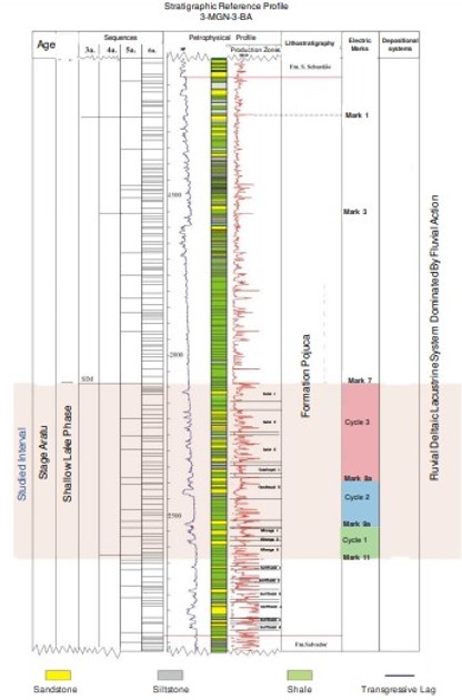
Fig. 3. Stratigraphic Reference Section.
Stratigraphy of the Recôncavo Basin
The stratigraphic concepts in the Recôncavo Basin evolved strongly since it is a highly prolific basin (Fig. 4).
The use of the stratigraphic nomenclature code for this basin was quite heterodox. Since the Recôncavo was a strongly structured basin, emphasis was given to both surface and subsurface mappings, and to biostratigraphic aspects (in their chronostratigraphic character), leaving lithostratigraphic aspects as secondary. Thus, “formations” were characterized not by their lithological aspects, but by biotic content (ostracods and pollen). With this, the task of visualizing structural traps was favored, since these depended on chronostratigraphic reference horizons (biozones or petrophysical marker beds) for the relative establishment of high or low blocks. The seismic surveys also worked in the same way, since today it is known that seismic reflectors basically mark time lines or geologic discontinuities, which, by nature, have a chronostratigraphic character. This allowed, for example, exploratory leases based on a structural map of Marker 11 bed, irrespective of which lithostratigraphic units this landmark might belong to.

Fig. 4. Stratigraphic column of the Recôncavo Basin (adapted from Caixeta et al., 1994).
The situation persisted until the early 1970s, when a new stratigraphic code was developed. This time, geological characteristics justified its use, however, it led to the wrong evolutionary model. Due to the influence of foreign consultants, who imported models from the Gulf of Mexico coast, it was proposed that the basin was a lake progressively filled by a protuberant fluvio-deltaic system, producing a giant offlap. All units, according to this model, would be genetically related. The ostracod biozones would mark earlier paleoecological situations rather than a temporal evolution. The petrophysical milestones, well accepted since the 1950s, and parallel to the biozones, were considered diachronous, cutting offlap time lines. Thus, the stratigraphy of the basin suffered an involution. This situation lasted until 1985, when the old concepts were reestablished after a long campaign of persuasion. This idea was later reinforced by Rossetti’s work in the Potiguar Basin (Rossetti, 1996), which seismically showed that there is progression in the rift, but this occurs only in small intervals, separated by lake-level fluctuation events.
Depositional Facies and Systems
The depositional systems involved in the Pojuca Formation are, most of the time, related to a shallow lake and to river systems that entered the basin, building lacustrine deltas. Thus, sandstone deposits represent systems ranging from the meandering fluvial, or eventually interlaced, in more arid times, through crevasse-splay-like constructions and, finally, deltas. The major controls of this type of deposit are, in order of importance, tectonic and lacustrine eustasy, the latter, in turn, controlled by climate. At the faulted edge of the basin, fault escarpments or fault lines likely control the formation of alluvial fans, which extended over the duration of sedimentation.
Fluvial Systems
The ubiquity of sandstones at certain stratigraphic intervals in the basin has already led geologists to think in a layer-cake scheme. This type of reasoning served to justify, later on, another absurdity, which was the total contempt for the indications of depositional surfaces or time surfaces (timelines), in which petrophysical landmarks and tops of biostratigraphic zones would fit, without considering seismic reflections, which are in themselves enlightening. However, Rossetti (1996) and Soares and Rossetti et al. (2005) demonstrated that, in the Potiguar Basin rift, relatively thin sandstones of regional extension are the product of very rapid progression of fluvio-deltaic systems.
The Imbé, Cambuqui and Miranga sandstones, which are in the studied interval, exhibit fluvio-deltaic facies. The cores that illustrate this monograph, cut in well 3-MG-99- BA (Fig. 5), are good examples of a meandering river system.

Fig. 5. Description of the sediments of the well 3MG-99-BA.
As an easy indication of the presence of these fluvial systems, it is enough to observe the curves of the spontaneous Potential Profiles (SP), which are of the “normal” type (Saitta-Bertoni and Visher, 1968). Marginal dykes, which separate point bar or river channel areas of the flood plain are characterized by the abundance of climbing ripples or ripple drift. Floodplains, by their nature, essentially clayey, when dried, become paleosols, which exhibit singular characteristics, such as fracturing type, and the presence of plant roots (Fig. 6). These characteristics are found in the core of well 3-MG-99-BA.

Fig. 6. Facies fluvial of the Buracica Stage. These facies are similars to the Aratu Stage. Note the flat erosional base. Campo de Araçás.
It is assumed that in arid times, there was a significant lowering in the level of the lake, as in the case of East Africa. On these occasions, due to floods or catastrophic floods, water would flow through a network of intertwined channels, in a wide alluvial plain, as occurs in Buracica Stage (Della Fбvera et al. (1994b). These bodies have "box" type profiles and can be recognized in platform areas.
In times of great rainfall, due to the rise of the lake level, the rivers are unable to transfer their load to the mouth, throwing it instead into the floodplain, in the form of crevasse-splays. These splays are organized as deltas, forming sigmoid lobes.
Source: STRATIGRAPHIC ANALYSIS OF THE ARATU STAGE (LOWER CRETACEOUS), RECÔNCAVO BASIN (BRAZIL), WITH HYDROCARBON RESERVOIR ROCKS. ORGE CARLOS DELLA FÁVERA1 , HERNANI AQUINI FERNANDES CHAVES, MARCO ANDRÉ MALMANN MEDEIROS, JORGE TIAGO LANCATES VILLARES, SHEILA FABIANA MARCELINO DE SOUZA, SIANA SOARES DE OLIVEIRA AND MARIA VIRGINIA ALVES MARTIN. Journal of Sedimentary Environments Published by Universidade do Estado do Rio de Janeiro 4 (2): 199-219. April-June, 2019
Следующий Бассейн: Beni Plain