Тип бассейна: Платформ
Подтип бассейна: Пассивных окраин (перикратонно-океанический)
Класс бассейна: Периокеанический
Возраст бассейна: Зрелый - Мезозойский
Тип полезных ископаемых:
Геологический возраст начало:
Геологический возраст конец:
Площадь: 32021.47 км²
Rio Muni Basin
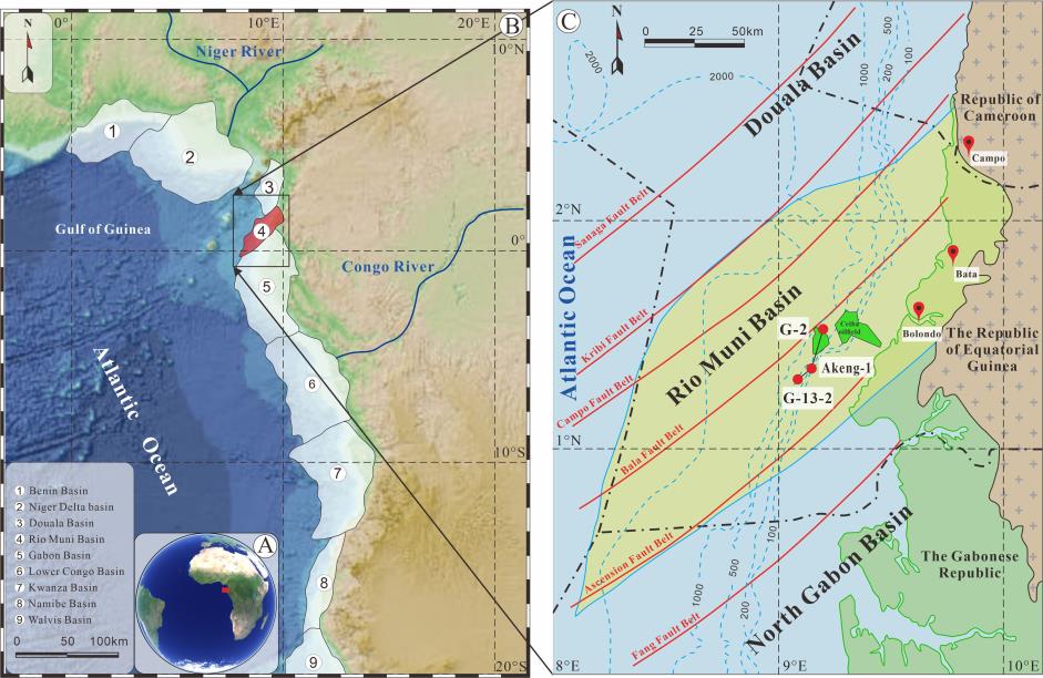
The Rio Muni Basin is located in southern Gulf Guinea, West Africa (Figure 1A, B), which is one of the most important petroliferous areas in the world. With the discovery of the Ceiba oil field in 1999, it directly demonstrated the immense oil and gas potential of the Rio Muni Basin. It is located in a location with shearing near the equator on the edge of West Africa. The north is controlled by the Kribi fault zone and is adjacent to the Douala Basin; the south is cut by the Ascension Fault zone and borders the North Gabon Basin; and it is located west of the Central African Precambrian shield (Figure 1B). The Rio Muni Basin covers a total area of 2.0*104 km2, of which 86% is offshore. Its conjugate basin is the petroliferous Sergipe Alagoas Basin in Brazil.
The formation and evolution of the passive continental margin in West Africa can be subdivided into four major stages that are closely related to the opening of the Atlantic Ocean. The Rio Muni Basin has also experienced a similar sedimentary evolution (Figure 2).
Fragmentation of the Gondwanan continent was accompanied by an eruption of continental rift basalt, and no prerift sequence survived it. In the Rio Muni Basin, very few wells have been drilled into the pre-Cretaceous formations, which consist of Precambrian feldspar-bearing sandstone and conglomerate.
With a series of tensional rifting events from south to north in the South Atlantic, theWest African coast has formed an onshore rift system controlled by NE-SW-trending basement fractures. The interlacing of horsts and grabens is the main tectonic pattern of the Rio Muni Basin. The faulted lake basin with a half-graben structure is filled with sapropelic lacustrine source rocks and terrestrial clastic rocks. The sedimentary centre is located in the eastern part of the basin, and the maximum sedimentary thickness is >4000 m, which decreases towards land.
Figure 1. (A) Geographical context of the Rio Muni Basin study area along the West African Margin. The location of the map in (C) is shown. (B) Distribution of the West African continental margin basins. (C) Location of the Rio Muni Basin (West Africa) between the main fractures of the Guinea Margin. Modified from Fu et al. The locations of wells G-2, Akeng-1, and G13-2 are identified in (C).
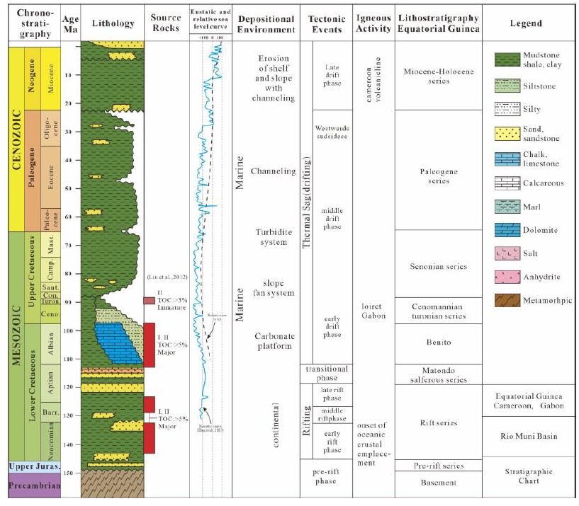
Figure 2. Stratigraphic chart of the Rio Muni Basin, Equatorial Guinea. Modified from Zhao et al. Prerift period (or intracratonic sag phase–Late Jurassic).
During this period, under the influence of the Walvis volcanic belt, seawater from the southern side periodically drained into the sedimentary basins (i.e., the Low Congo Basin, the Gabon Basin, the Rio Muni Basin, etc.) on the northern side of the South Atlantic, resulting in the development of extensive evaporite deposits in these basins. These evaporites formed a continuous blanket extending from the southern regions of the Douala basin to the northern reaches of the Namibe basin, recording the first transgression in the South Atlantic.
Continued ocean accretion and continental drift led to the further opening of the South Atlantic. The Rio Muni Basin entered the passive continental margin stage from this phase. During this period, the basin experienced early gravity deformation, basin inversion and folding, and late gravity deformation phases. This stage can be divided into three super sequences according to the major changes in the sedimentary environment and widespread unconformities. A restricted marine supersequence characterised by high salinity and hypoxia in shallow marine environments originated from high-energy shallow water carbonate deposits in a ramp/platform environment. During this period, a set of marine source rocks with a total organic carbon (TOC) content higher than 5% and predominantly Type II organic matter, with a smaller amount of Type I, developed, serving as the major hydrocarbon source rocks in the Rio Muni Basin. The top is marked by black shale rich in organic matter. The open marine super sequence (or middle postrift stage—Turonian to present) indicates that the ancient water depth reached 1000–2000 m beyond the present-day continental shelf and that the sedimentary environment was stable, which represents the marine sedimentary stage. A set of marine source rocks developed, with a total organic carbon (TOC) content higher than 3%, predominantly consisting of Type II kerogen, and exhibiting immaturity. The third super sequence can be distinguished locally, i.e., as a delta super sequence. The northward movement of the African plate gives the continental margin a tropical and humid climate, enhances erosion, and results in the development of a set of downwards-inclined wedge-shaped delta super sequences on the continental shelf slope.
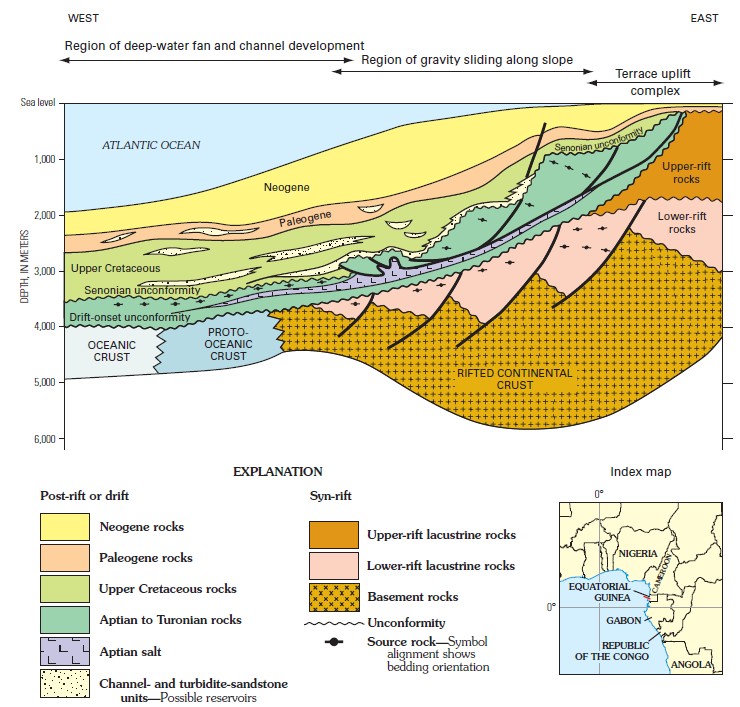
Figure 3. Generalized cross section, showing position of probable source rocks of the Rio Muni Basin, Equatorial Guinea, west Africa. Formation names and lithology are shown in figure 10 for the syn-rift and post-rift units. Modified from Equatorial Guinea Ministry of Mines and Energy (2003). Location of the cross section shown by short red line in index map. Horizontal scale generalized; not given.
Data source:Lithofacies and Depositional Models of the Fine-Grained
Sedimentary Rocks of the Albian–Turonian Stage in the Rio Muni Basin, West Africa. Bin Zhang, Zhiwei Zeng, Hongtao Zhu, Xianghua Yang and Linan Pang. 2023
Geology and Total Petroleum Systems of the West-Central Coastal Province (7203), West Africa Geology. U.S. Geological Survey, Reston, Virginia: 2006
Следующий Бассейн: Kwanza