Тип бассейна:
Подтип бассейна:
Класс бассейна:
Возраст бассейна:
Тип полезных ископаемых:
Геологический возраст начало:
Геологический возраст конец:
Площадь: 116361.57 км²
Rovuma Basin
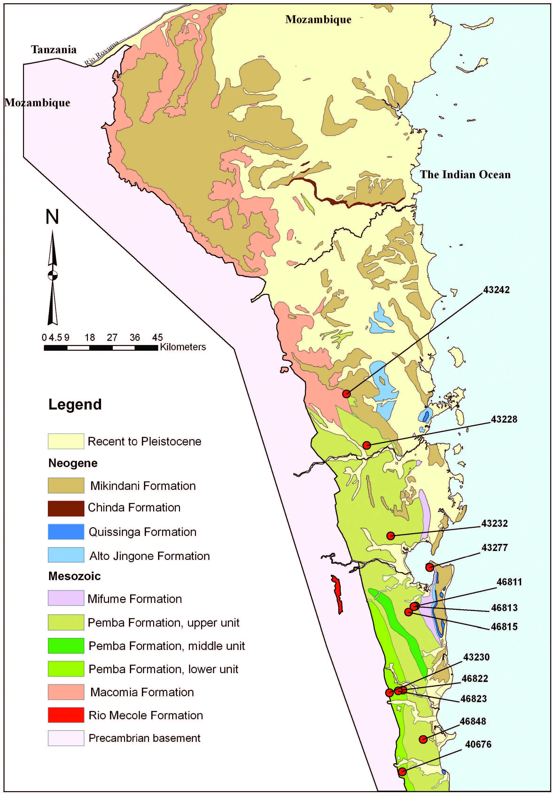
The Rovuma Basin is a southern extension of the East Africa Basin and extends for about 400 km from southern Tanzania as far south as Nacala in northern Mozambique. It has a maximum east–west width of about 160 km in northern Mozambique. The Mesozoic basin fill unconformably overlies Neoproterozoic to Ordovician igneous and metamorphic rocks of the Mozambique Belt. The onshore western margin is mostly defined by NNW-trending faults that form low scarp features bounded to the west by exposed Mozambique Belt rocks. In contrast to the much better studied Mozambique Basin of southern Mozambique, the stratigraphy of Rovuma Basin is poorly known.
Geologic map of the Rovuma Basin, northern Mozambique, illustrating the locations of the samples included in the present study.
LITHOSTRATIGRAPHY
A revised lithostratigraphy of the Rovuma Basin, onshore Mozambique was published by Smelror, Key, Smith et al. (2006) and Key et al. (2008). It is based on fieldwork and the available literature. The new stratigraphic nomenclature uses place names in northern Mozambique for the lithostratigraphic units. The Macomia Formation was first described as sandstones exposed in southern Tanzania, and was previously termed the Makonde Beds. The Macomia Formation comprises 80–320 m of generally coarse-grained siliciclastic strata, predominantly conglomerates and sandstones with less common siltstones, which are locally graded. It extends
across the Rovuma River and forms the Makonde Plateau of northern Mozambique. Hancox et al. (2002) determined the depositional setting to be a marginal marine lagoon with fluvial channels, overlain by cyclic braided rivers (i.e. a distal alluvial fan) and alluvial/marginal marine fans. Hancox et al. (2002) termed this unit the Maconde Formation; this unit was assigned a late Aptian–early Albian age.
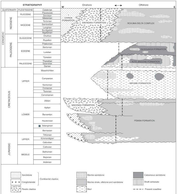
Stratigraphic framework of the Rovuma Basin (from Smelror, Key, Smith et al., 2006).
To the south, in the Muaguide–Quissinga area, the Macomia Formation passes laterally into the marine Pemba Formation, which underlies the entire western and southern part of the Rovuma Basin. The Pemba Formation comprises sandstones, siltstones, and minor mudstones. It was previously assigned to the ‘Megatrigonia schwartzi Beds’ and ‘Aptian–Albian sandstones and marls’ (Flores, 1960). Civitelli (1988) used the terms ‘Conglomerates and sandstones’ and ‘Belemnite bearing sandstones and marls’ for the Pemba Formation.
This unit represents coastal progradation into an open marine environment and is divided into three. These are, in ascending stratigraphic order, coarsening-upwards sandstones interbedded with limestones and mudstones; flaggy, well-bedded sandstone; and turbiditic interbedded mudstones, sandstones, and siltstones. The upper part of the Pemba Formation contains an abundant marine biota, including belemnites, bivalves, dinoflagellate cysts, and foraminifera, which indicate an Aptian–Albian age.
The boundary between the Pemba Formation and the overlying Mifume Formation is marked onshore by a major unconformity. The Mifume Formation, previously known as the Globotruncana Formation, consists of calcareous sandstones and intensely bioturbated marls with worm burrows. It is about 200 m thick west of Pemba, and 915 m thick in the Mocimboa-1 borehole (Salman and Abdula, 1995). Civitelli (1988) assigned the Mifume Formation to the middle Campanian to middle Maastrichtian.
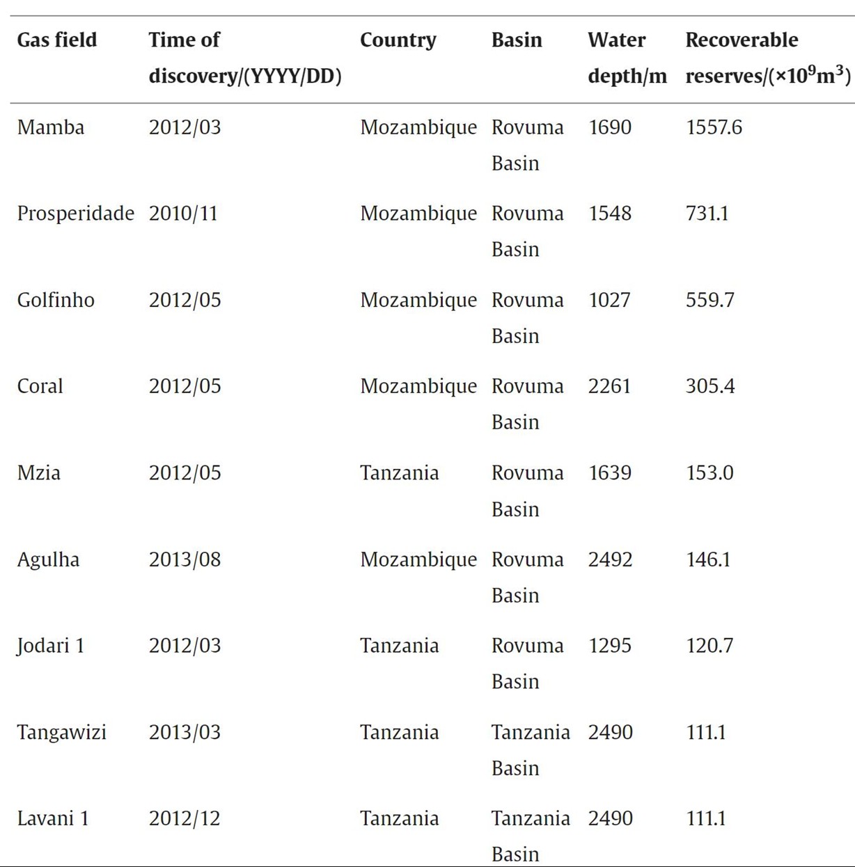
East Africa passive continental margin refers to shore lines of East Africa south of Somalia. It includes 7 basins: Somalia, Ramu, Tanzania, Rovuma, Zambezi Delta, Morondava and Majunga. Drilling and exploration operations along coastal lines of East Africa started in 1958. Up to 2010, only 7 medium- or small-sized gas fields with commercial values had been found in on-shore and shallow-water zones. Since August 2010, exploration operations switched into deepwater and ultra-deep waters. Up until the end of 2014, 36 medium- or large-sized gas fields, including 9 deepwater major gas fields, had been found in the Rovuma Basin and the Tanzania Basin. With success rates over 80% for exploration wells, East Africa is currently a hot spot for natural gas exploration in the world.

Distribution of basins and deepwater gas fields in East Africa (according to Ref.).
Table Deepwater giant gas fields in East Africa.
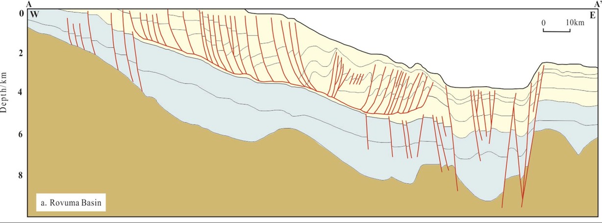

Geological section of Rovuma basin in East Africa.
The East African passive continental margin basins contain 3 packages of hydrocarbon source rocks: Upper Carboniferous–Lower Jurassic continental shale and coal measures, Middle-Upper Jurassic–Cretaceous marine shale, and Paleogene–Neogene continental shelf–slope shale. Middle-Upper Jurassic–Cretaceous marine shale can be seen as the dominant hydrocarbon source rocks of shore basins in East Africa. The Permian–Neogene formations often contain multiple reservoirs dominated by delta sandstone and deep-sea turbidite sandstone, distributed mostly in the Rovuma Basin and Tanzania Basin. Cap rocks are predominantly marine shale with thick evaporite developed regionally. Majority of traps are structural traps with hydrocarbons migrating along faults to form reservoirs.
Currently, all of the discoveries in deepwater areas of East Africa are distributed in the northern Rovuma Delta Basin and slopes of the Tanzania Basin. With a low overall exploration degree, deepwater areas may present great potential for future exploration operations.
Data source: Giant discoveries of oil and gas fields in global deepwaters in the past 40 years and the prospect of exploration. Gongcheng Zhang, Hongjun Qu, Guojun Chen, Chong Zhao, Fenglian Zhang, Haizhang Yang, Zhao Zhao, Ming Ma. 2019
LATE JURASSIC AND CRETACEOUS PALYNOSTRATIGRAPHY OF THE ONSHORE
ROVUMA BASIN, NORTHERN MOZAMBIQUE. MORTEN SMELROR, ROGER M. KEY, RICHARD A. SMITH, FERNANDO NJANGE. 2008
Следующий Бассейн: Red Sea