Тип бассейна:
Подтип бассейна:
Класс бассейна:
Возраст бассейна:
Тип полезных ископаемых:
Геологический возраст начало:
Геологический возраст конец:
Площадь: 576462.56 км²
Solimoes Basin
Geological setting
The Solimoes Basin is a large cratonic sag that covers around 600 000 km2 of northwestern of Brazil, containing up to 4.5 km of marine to continental Palaeozoic deposits covered by Cretaceous to Tertiary continental deposits. Eohercynian extension caused normal faulting and uplift of the source areas of Brazilian Shield to the south, the Guyanas Shield to the north, and the Carauari Arch, which divided the Solimo˜es Basin into the Jandiatuba and Jurua´ sub-basins. The Carauari Arch exerted an important control over the pre-Pennsylvanian sedimentation. Late Triassic to Early Jurassic diabase sills and dykes were intruded in the Devonian, Carboniferous and Permian sequences around 210 and 220 Ma ago, according to Ar/Ar dating (Szatmari, 1996). The thermal pulse related to this basic magmatism played an important role in hydrocarbon generation, expulsion and migration from the Devonian source rocks to Devonian and Carboniferous reservoirs (Caputo & Silva, 1990). The extensional period was followed by Jurassic–Cretaceous transpressional tectonism, related to the Andean orogenic events, which gave the area its present configuration (Caputo & Silva, 1990). Large compressional structures, in the form of reverse faults and asymmetrical folds constitute the main hydrocarbon traps.
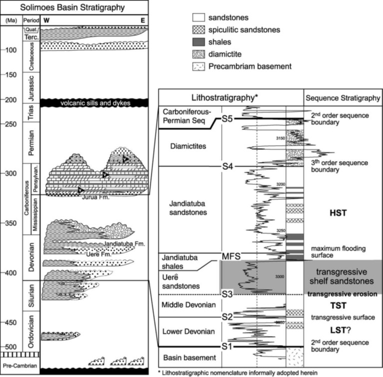
The basin was filled by six second-order depositional sequences: Ordovician, Silurian-Devonian, Devonian-Carboniferous, Carboniferous-Permian, Cretaceous and Tertiary (Eiras et al., 1994; Fig. 1). The Devonian-Carboniferous Sequence represents a transgressive-regressive cycle composed of four successions, separated by regionally extensive sequence boundaries, identified by miospore biostratigraphy (Grahn, 1992; Loboziak, Melo, Quadros, Daemon, & Barrilari, 1994; Silva, 1987; Fig. 2). The most basal succession is comprised of prograding Lower Devonian deposits (Fig. 2) that occur only in the deeper Jandiatuba Sub-Basin and western portion of Jurua´ Sub-Basin. Over a possibly transgressive surface (S2; Fig. 1), retro- to aggradational, Eifelian-Early Givetian deposits occur at the depocentre of Jurua´ Sub-Basin and eastern Jandiatuba SubBasin. Early Givetian (?)-Frasnian sandstones and cherts (informally herein named Uereˆ sandstone) lay uncomformably on Middle Devonian deposits and Precambrian metasediments and granitoids. The Uereˆ sandstones represent a progradational to aggradational succession limited at the base by a regional erosional surface (S3; Fig. 2).
Fig. 1. Simplified stratigraphic chart of the Solimoes Basin (modified from Eiras et al., 1994) and detailed Devonian Sequence stratigraphy within the Sao Mateus Field area (well NSM-1). Lithostratigraphic nomenclature informally adopted herein. LST, lowstand system tract; TST, transgressive system tract; HST, highstand system tract. Two second-order sequence discontinuities (S1 and S5) bound the Devonian Sequence. S3 is a regionally correlatable surface, corresponding to a transgressive erosion below the Uere sandstones.
Radioactive Frasnian Jandiatuba shales regionally cover the Uereˆ sandstones along the Devonian maximum flooding surface (MFS; Fig. 2), constituting the main source rock of the Basin (TOC av. 1.0%, up to 8.25%; Eiras, 1998; Grahn, 1992; Mello et al., 1994; Silva, 1987). Towards the eastern margin of the basin, the Jandiatuba shales are downlapped by a 50 m thick, progradational succession of Famennian sandstones rich in siliciceous sponge spicules interbedded with shales and minor conglomerates of mud and chert intraclasts reworked from the underlying Late Devonian deposits, informally named Jandiatuba sandstones (Fig. 2).
A marked erosive boundary (S4; Fig. 2) cuts the Frasnian-Famennian shales and sandstones, and is covered by latest Famennian-Tournaisian glacial diamictites (Caplan & Bustin, 1999; Caputo & Crowell, 1985; Johnson, Klapper, & Sandberg, 1985; Streel, Caputo, Loboziak, & Melo, 2000), corresponding to a worldwide glacio-eustatic regression known as the Hangenberg Event (Caplan & Bustin, 1999; Streel et al., 2000). A regional erosive surface (S5; Figs. 2 and 3(A)–(C)) separates the CarboniferousDevonian Sequence from thick (,800–1200 m) marginal marine evaporites, minor carbonate and siliciclastic deposits of the Carboniferous-Permian Sequence (Eiras et al., 1994).
Depositional facies of the Uere sandstones
The Uereˆ reservoir sandstones extend throughout the Devonian southern palaeomargin of the Solimoes Basin (Figs. 1). The entire succession is 20–60 m thick, and is characterised by sharp-based, aggradationally to progradationally stacked sandstone deposits. The presence of a basal erosional discontinuity (S3 surface) is suggested by (1) truncation of underlying Lower to Middle Devonian deposits and (2) lateral continuity of the individual facies contained between the basal discontinuity surface and overlying Jandiatuba shales. Three facies associations were identified in the Uereˆ sandstones, which are arranged in a coarsening-upward trend from the muddy facies association 3 to sandy facies association 1. The following interpretations are based on comparisons with facies and processes of modern shelves (Snedden & Nummedal, 1991).
Stratigraphic framework
The Devonian section was deposited in a very flat, shallow and wide intracratonic depression, without a distinct shelf/slope break. Therefore, the extremely low relief of the basin implies that a change of a few meters in relative sea level would cause the flooding of large areas.
There is a great lateral continuity (<200 km) of the
facies associations contained between the discontinuity surface S3 and the Jandiatuba shales. In their distal (NW) edge, there is a dominance of facies associations 2 and 3.
The general progradational pattern of the Uere deposits was overlain by a MFS, represented by the transgressive Jandiatuba shales (Silva, 1987). Two mechanisms could be invoked to explain the deposition of these organic-rich shales: (1) encroachment of the epicontinental sea by an oxygen-minimum zone during late Famennian flooding (Savoy, 1992); (2) upwelling (Caplan & Bustin, 1996;
Savoy, 1992). High rates of primary productivity at the sea floor are evidenced by the abundance of sponges, a common constituent of siliceous deposits related to ancient upwelling cells (Caplan & Bustin, 1999; Parrish, 1982; Savoy, 1992).
The possible stratigraphic settings for the progradation of storm-influenced shelf deposits underlain by erosional surfaces are those of forced-regressive (falling relative sealevel stage) and lowstand complexes. Both are allocyclic, overlying genetically unrelated deposits and basally bounded by sequence- tratigraphically important discontinuities (Hunt & Tucker, 1992; Posamentier, 2002; Posamentier,
Allen, James, & Tesson, 1992; Walker & Bergman, 1993; Walker & Wiseman, 1995). The evidence to reject a forcedregressive scenario for the Uereˆ sandstones is that, in such settings, the submarine component underlying the shallow marine deposits extends only as far seaward as storm wave base reach, extending below that only as non-erosional correlative conformities (MacEachern, Zaitlin, & Pemberton, 1999). Conversely, the base of Uere sandstones is markedly erosional hroughout the basin. Additionally, it must be noted that in the distal areas (e.g. western Jurua Sub- Basin) Uereˆ sandstones basal boundaries (S3) remains erosional even where facies association 3 was deposited below fair-weather wave base. In the trangressively incised shoreface scenario the basal discontinuity is cut during relative sea-level stillstand prior to progradation, being after modified by wave ravinement during transgression (Downing & Walker, 1988). The resulting basal surface is erosive and correlatable basinward, as observed in Uereˆ sandstones (MacEachern et al., 1999). Glaucony ooids that occur dispersed in the Uere sandstones are also consistent with a transgressive scenario.
Data source: The role of depositional setting and diagenesis on the reservoir quality of Devonian sandstones from the Solimo˜es Basin, Brazilian Amazonia. Rodrigo Dias Lima, Luiz Fernando De Ros. Marine and Petroleum Geology 19 (2002) 1047–1071.
Следующий Бассейн: Altiplano