Тип бассейна:
Подтип бассейна:
Класс бассейна:
Возраст бассейна:
Тип полезных ископаемых:
Геологический возраст начало:
Геологический возраст конец:
Площадь: 100890.9 км²
Sulaiman fold-thrust belt
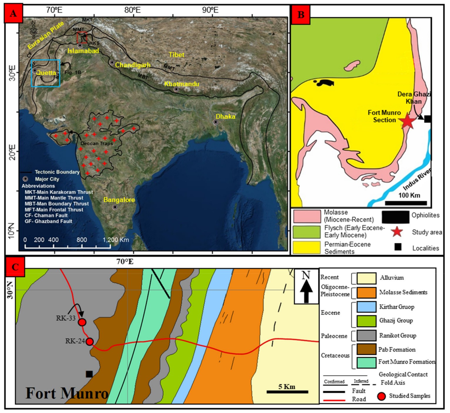
The Sulaiman fold-and-thrust belt is an active tectonic feature of the Himalayan mountain system in Pakistan. The Sulaiman fold-thrust belt (SFB) was developed in response to the oblique collision of the Indian plate with the Afghan block (Asian Plate). The SFB is ~300 km wide and has a curved lobe-shaped asymmetrical structure (Figure 1A, B). Its eastern boundary is marked by the Sulaiman range, which is oriented N–S. The younger (Pleistocene–Oligocene) rocks are exposed along the eastern edge of the SFB, while older (Eocene–Cretaceous) rocks are exposed towards the western edge of the SFB. The older strata in the SFB are exposed consistently in the core of the anticlines without the existence of emergent thrust in the foreland. This impression of the stratigraphy suggests monoclinal structure of the eastern SFB. In the southern SFB, the monoclinal structure is less pronounced than the eastern SFB, with wide detachment folds over the basement. At the western and northern boundary of the SFB, the ophiolitic sequence is emplaced over the Cretaceous–Eocene sedimentary rocks and marked by the Zhob valley thrust (Figure 1B).
Fig. 1. (A) Generalized map showing regional tectonic features. The location of Sulaiman foldthrust belt (SFB) is marked by blue rectangle. The red rectangle shows the Hazara–Kashmir syntaxial bend (After). (B) The simplified geological map of SFB showing the location of the studied section (After). (C) Modified geological map of the Fort Munro area showing major stratigraphic units and locations of the studied samples (After).
The stratigraphy of the SFB is generally subdivided into three groups: Permian-Eocene carbonate sedimentary rocks, Eocene–Oligocene Khojak flysch overlies the Muslimbagh ophiolite and Oligocene Recent molasses. The Ranikot Formation is exposed in the anticlinal structure at the eastern edge of SFB. It mainly consists of varied color sandstones with intercalations of shale and limestone (Figure 2A, B). The limestone is grey with thickness varying between 10 cm to 30 cm. The shales are calcareous and occur in the lower part of the formation. The contact relationship of the Ranikot Formation with the Cretaceous Pab Formation is unconformable and marked by the erosional surface, while the upper contact with the Dunghan Formation is conformable. The age assigned to the Ranikot Formation is Early Paleocene (Danian).
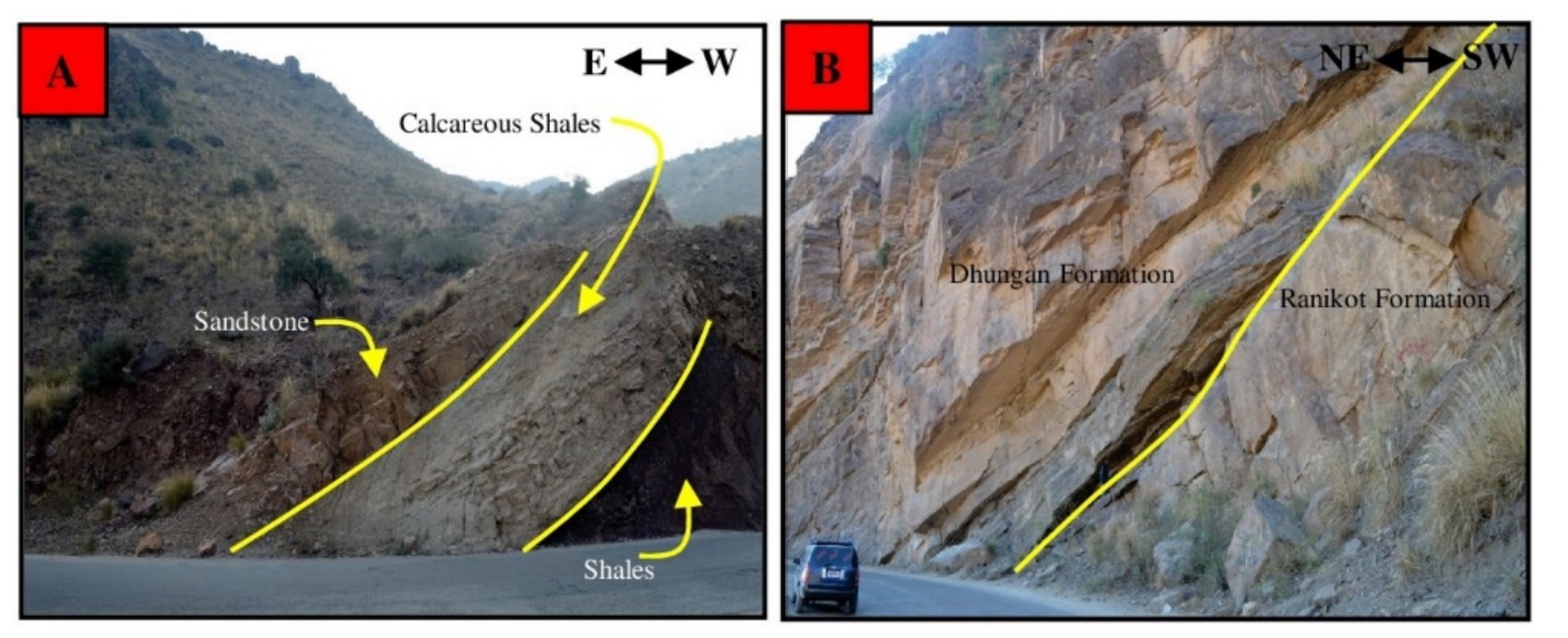
Fig. 2. Field photographs showing various lithological units and geological contacts. (A) sandstone of the Ranikot Formation at lower contact with calcareous shales of the Pab Formation. (B) Upper contact with Dunghan Formation.
Tectonic setting of the Sulaiman fold and thrust belt
The Sulaiman fold and thrust belt (see Fig. 1 for location) is the broadest fold and thrust belt of the Himalayan foreland basins (Jadoon et al. 1994a). It comprises a passive roof duplex (Banks & Warburton 1986) formed in response to the oblique collision between the Indian subcontinent and the Eurasia plate (Jadoon & Khurshid 1996). The initial collision event in the Sulaiman fold and thrust belt is recorded by the emplacement of the Muslimbagh ophiolites, which occurred either at the Cretaceous–Tertiary boundary (Gnos et al. 1997), or later in the Palaeocene–early Eocene (Allemann 1979). Since the late Oligocene–early Miocene, renewed southward thrusting has reworked the Palaeogene deposits as the deformation front migrated southward and eastward (Banks & Warburton 1986;Waheed & Wells 1990). The initiation of the Chaman left-lateral strike-slip fault occurred between the late Oligocene and the early Miocene, when the shortening to the south of the Muslimbagh ophiolites became significant (25 +- 5 Ma, Jadoon & Khurshid 1996). Southward thrusting of the Neogene deposits is still continuing (Jadoon et al. 1994b).
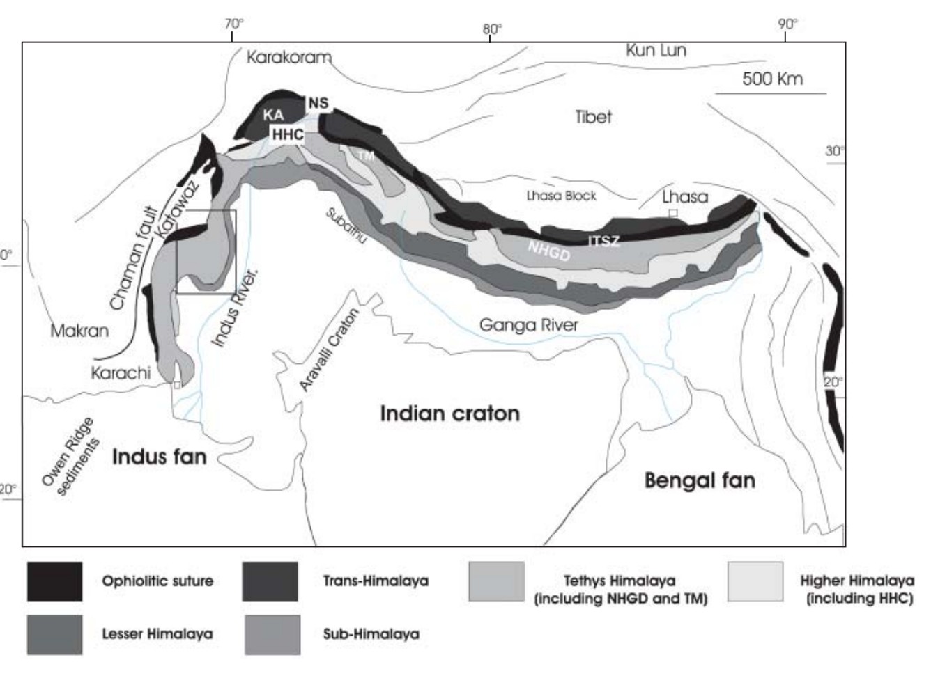
Fig. 3. Simplified geological map of Himalaya (modified from Najman 2006). Rectangle indicates the location of Figure 2. HHC, Higher Himalayan Crystallines; KA, Kohistan Arc; NHGD, North Himalayan gneissic domes; NS, Northern Suture; ITSZ, Indus–Tsangpo Suture Zone; TM, Tso Morari. (See Table 6 for main characteristics of these units.)
The frontal portion of the Sulaiman fold and thrust belt, which encompasses 10 000 km2 of the Sulaiman Lobe, consists of an east–west-trending doubly plunging fold (Jadoon et al. 1994b).
Sequential restoration of a balanced cross-section across the Sulaiman fold and thrust belt shows that the Loti anticline (see Fig. 4 for location) first developed as a result of a broad concentric detachment folding at the fault tip (Jadoon et al. 1994a). This detachment was followed by the development of a passive roof duplex. Southward propagation of the duplex produced the Pirkoh anticline and the Bugti syncline (Jadoon et al. 1994a).
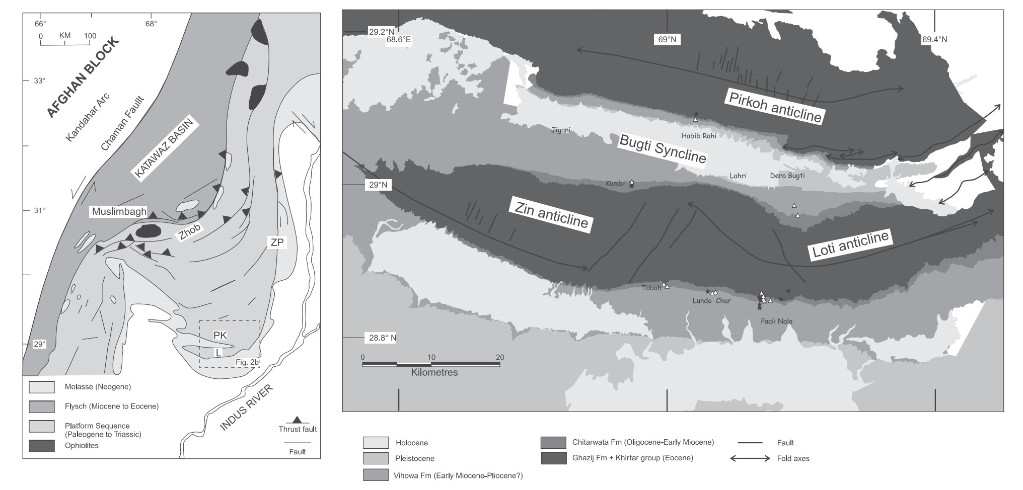
Fig. 4. (a) Generalized geological map of the Sulaiman fold and thrust belt (modified from Jadoon et al. 1994a). Box shows the location of (b). PK, Pirkoh anticline; L, Loti anticline; ZP, Zinda Pir dome. (b) Geological map of the study area. Location of sample outcrops is indicated by black stars (mudstones) and white triangles (sandstones). (See Table 1 for coordinates.).
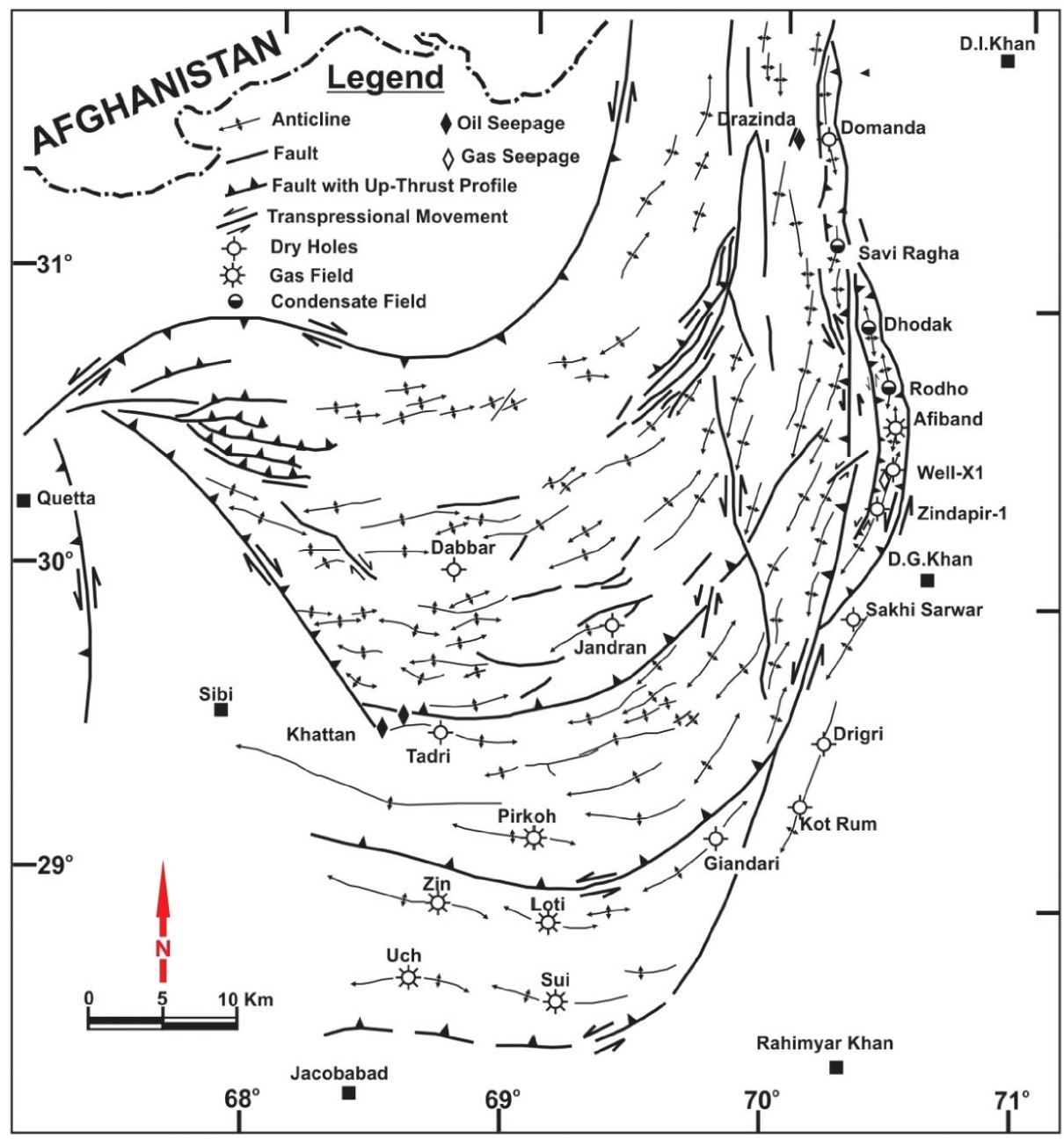
Fig. 5 - Structural and tectonic features of Sulaiman Fold Belt; locations of dry holes and producing fields (after Ali et.al, 1995).
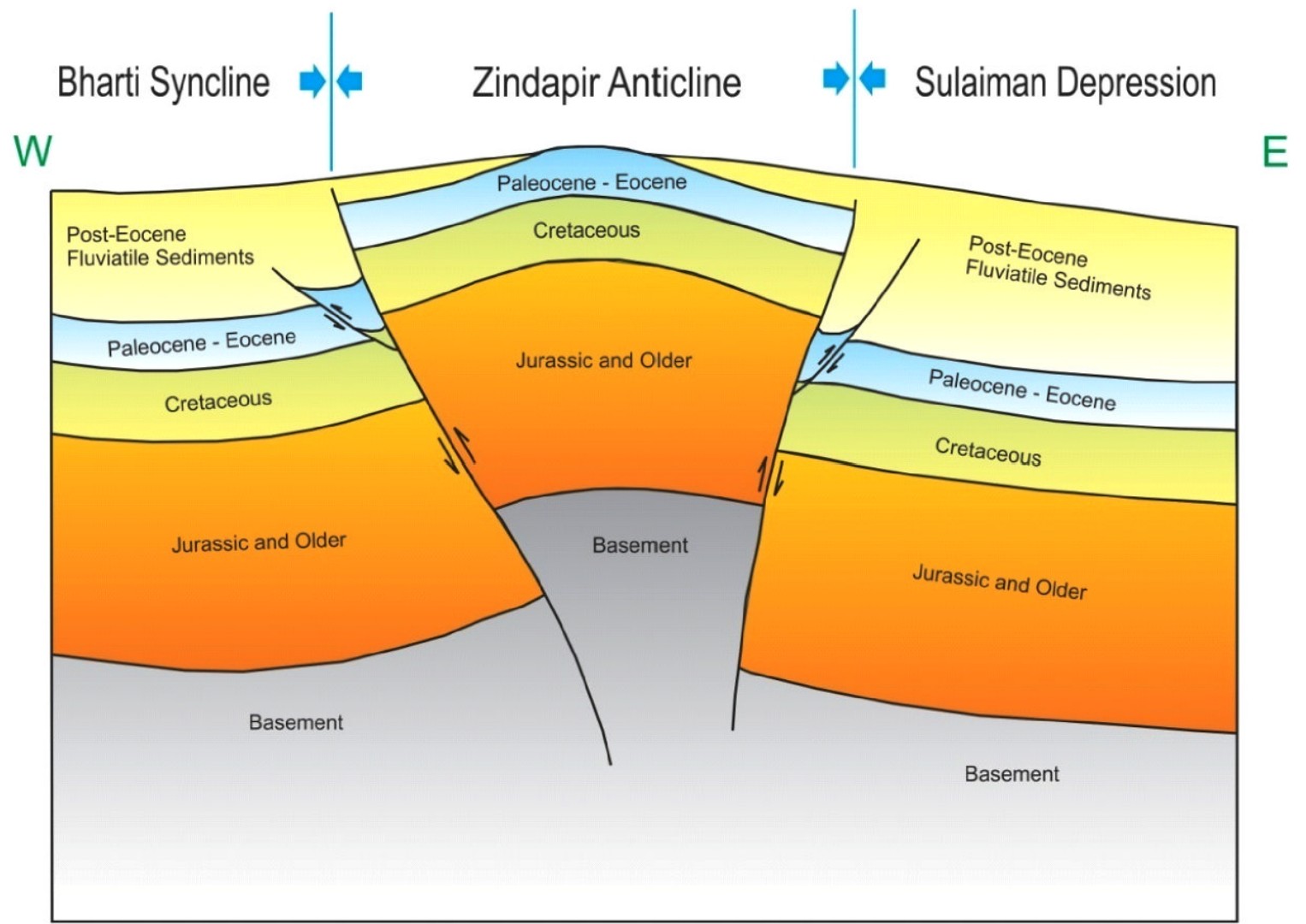
Schematic cross-sections across Sulaiman Depression, Zindapir Anticline and Bharti Syncline showing structural pattern associated with transpressional regime
Stratigraphy of the Sulaiman fold and thrust belt
The sedimentary succession of the Sulaiman fold and thrust belt (Fig. 6) includes: (1) the early Eocene Ghazij Formation; (2) the middle–late Eocene Kirthar group; (3) the Oligocene–early Miocene Chitarwata Formation; (4) the late early to middle Miocene Vihowa Formation; (5) the middle Miocene–Pliocene deposits of the Siwalik group.
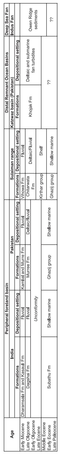
Fig. 6. Stratigraphical chart and depositional setting of western Himalayan sediment repositories (adapted from Najman 2006). Fm, Formation; Mb, Member.
The early Eocene Ghazij Formation records the first evidence of the collision between India and Eurasia (Warwick et al. 1998; Najman 2006). It consists of marine mudstones that pass upward to paralic sandstones and mudstones and to continental mudstones and conglomerates (Warwick et al. 1998) mainly derived from reworking of sedimentary rocks plus a subordinate igneous source that shed chromites and fragments of basic volcanic rocks, which may be indicative of an ophiolitic source (Warwick et al. 1998; Najman 2006). The middle–late Eocene Kirthar group consists of carbonates, marls and mudstone shelf deposits (Blanford, 1879; Williams 1959; Shah 1977; Gingerich et al. 1979). The Oligocene–early Miocene Chitarwata Formation consists of deltaic deposits at its base that grade upward to fluvial deposits (Me´tais et al. 2009). The Chitarwata Formation is widely exposed throughout the eastern part of the Sulaiman Range, and consists of coastal, deltaic, and fluvial deposits that have yielded numerous fossil vertebrates ranging from the earliest Oligocene to the late early Miocene (Antoine et al. 2010). At Chitarwata Post in the Zinda Pir dome (see location in Fig. 2a), the thickness of the Chitarwata Formation is c. 567 m (Lindsay et al. 2005) whereas in our study area, it does not exceed 260 m (Fig. 7).
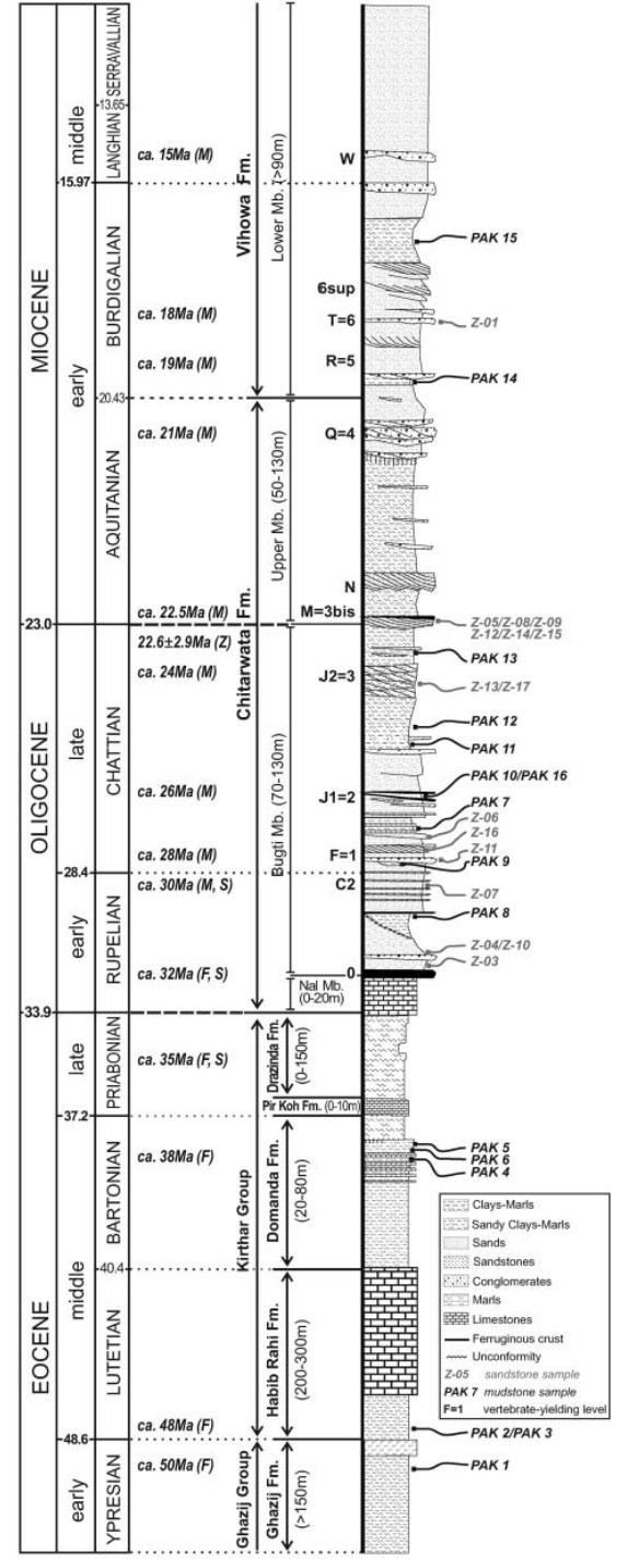
Fig. 7. Composite stratigraphic section of Cenozoic deposits of the study area and the location of mudstones (PAK1 to PAK16) and sandstones (Z-01 to Z-17) within the series. To the left, standard ages are those provided by Gradstein & Ogg (2006). In the middle column, the numeric ages provided are tentative and based on biochronology (M, mammals; S, selachians; F, foraminiferans). Modified from Welcomme et al. (2001), Antoine et al. (2003, 2004, 2010), Adnet et al. (2007) and Me´tais et al. (2009).
In the Zinda Pir area, the Chitarwata Formation was originally considered as entirely early Miocene in age on the basis of vertebrate fossil assemblages (Downing et al. 1993) and preliminary magnetostratigraphical data (Friedman et al. 1992). However, Lindsay et al. (2005) reinterpreted the magnetostratigraphical sequence of the Zinda Pir area in the light of new biostratigraphical data of Welcomme et al. (2001) and assigned an Oligocene–Early Miocene age to the Chitarwata Formation. The base of the fossiliferous sequence of the Chitarwata Formation in the Bugti Hills (0 and C2 horizons) is early Oligocene in age as indicated by the foraminiferan and mammal biostratigraphy (Welcomme et al. 2001; Me´tais et al. 2009). As emphasized by these later researchers, the apparent discrepancy in age between deposits of the Zinda Pir area and those of the Bugti Hills could be due to the existence of many stratigraphic hiatuses. These hiatuses render the correlation between these two areas difficult to establish and explain the fact that the lower Member of the Chitarwata Formation (‘Bugti Member’) is a condensed sequence that may represent a time interval not yet recorded elsewhere in the Sulaiman fold and thrust belt. The basal contact of the Chitarwata Formation with the Kirthar group is unconformable (Welcomme et al. 2001). The early to middle Miocene Vihowa Formation, made up of fluvial sandstones and microconglomerates associated with lacustrine marls, conformably overlies the Chitarwata Formation (Me´tais et al. 2009). Overlying the Vihowa Formation are fluvial deposits of the Siwalik group (Welcomme et al. 2001). Palaeocurrent measurements from planar cross-bedded and trough cross-bedded sandstones of the Chitarwata and Vihowa formations support a dominant southeastward palaeoflow direction during the deposition of these formations (Downing & Lindsay 2005). Waheed & Wells (1990) found a similar southward direction in the formation they called the post-Oligocene molasse of the Sulaiman Range, which is time equivalent of the Chitarwata and Vihowa formations. To study further the provenance of these rocks, 17 sandstones (Z-01 to Z-17) and 16 mudstones (PAK 1 to PAK 16) from the Ghazij Formation, Kirthar group and Chitarwata and Vihowa formations were collected in 2004. Sample locations are shown in Table 1 and Figure 2.
Table 1. Location, age and average grain size (mud or sand) for analysed sediments
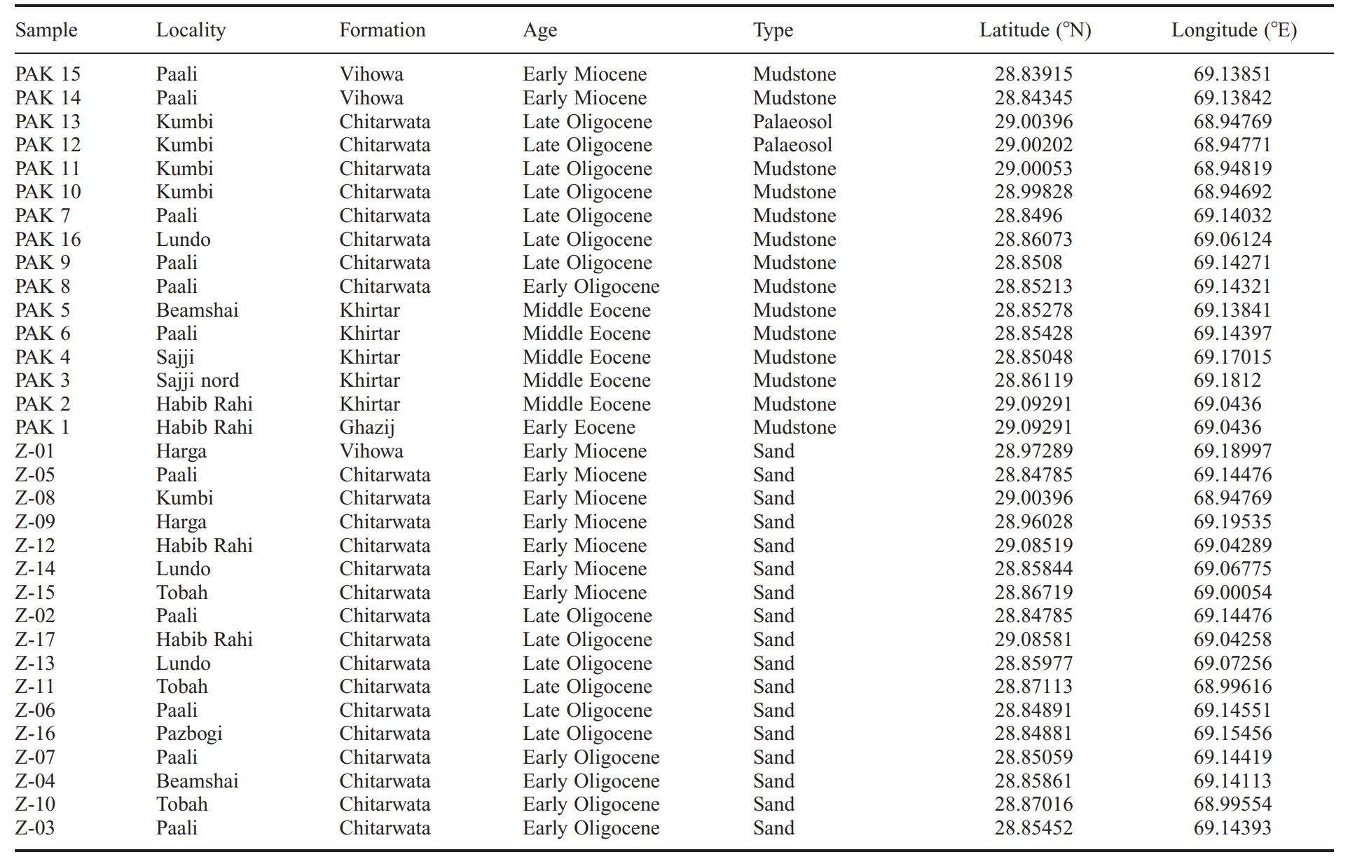
Figure 7 locates the samples in a composite stratigraphical column of the area. The age of the samples ranges from early Eocene (c. 50 Ma) to early Miocene (18–15 Ma).
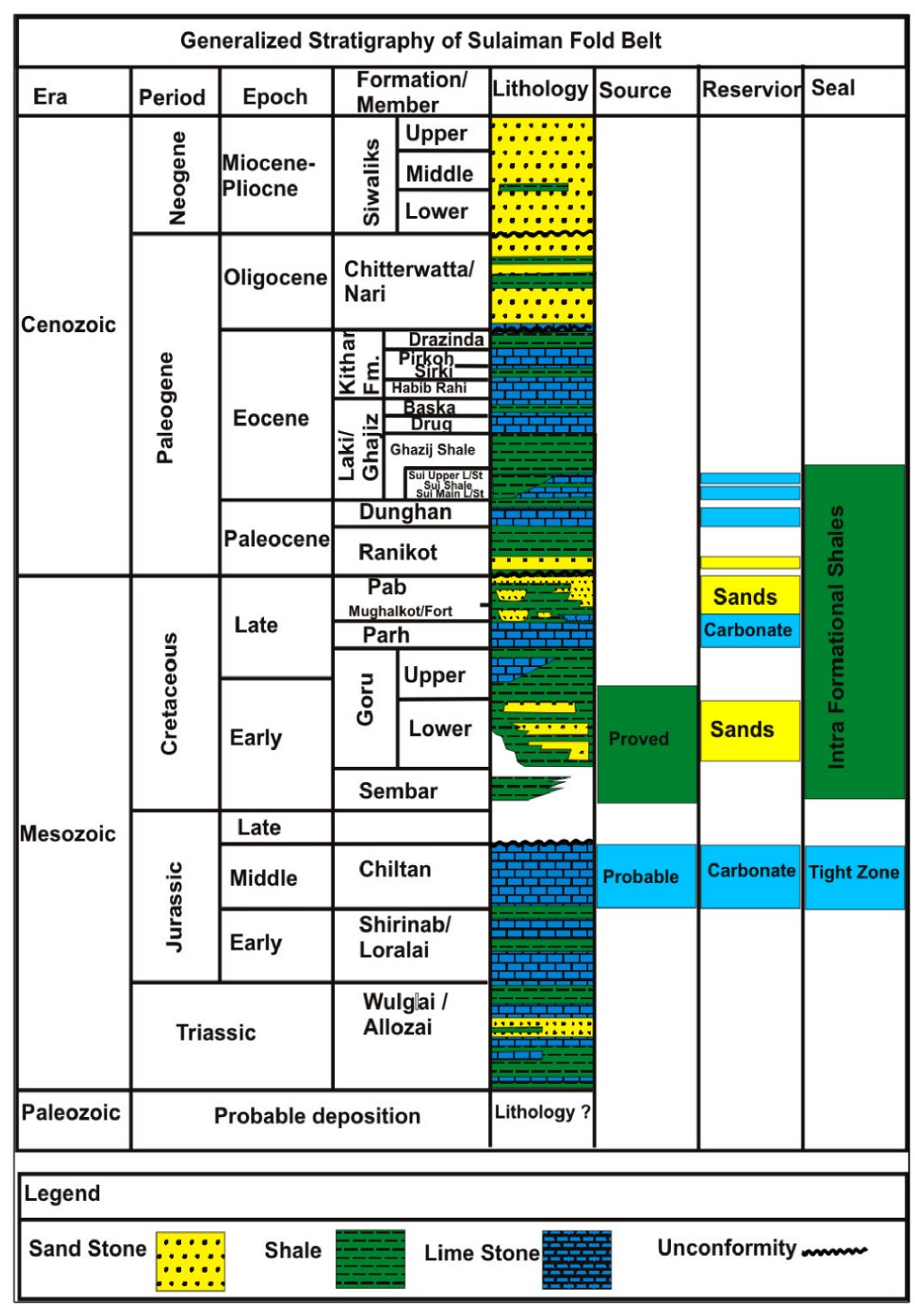
Fig. 8 - Generalized stratigraphy of Sulaiman Fold Belt
Data source: The Early Paleocene Ranikot Formation, Sulaiman Fold-Thrust Belt, Pakistan: Detrital Zircon Provenance and Tectonic Implications Muhammad Qasim, Junaid Ashraf, Lin Ding, Javed Iqbal Tanoli, Imran Khan, Mohib Ur Rehman, Muhammad Awais, Jalil Ahmad, Owais Tayyab and Ishtiaq Ahmad Khan Jadoon. 2023
Provenance of Cenozoic sedimentary rocks from the Sulaiman fold and thrust belt, Pakistan: implications for the palaeogeography of the Indus drainage system. Martin Roddaz, Aymen Said, Stéphane Guillot, et al. Journal of the Geological Society 2011.
Hydrocarbon Potential of Zinda Pir Anticline, Eastern Sulaiman Fold Belt, Middle Indus Basin, Pakistan.Adeel Nazeer, Sarfraz H. Solangi , Imdad A. Brohi , Parveen Usmani , Latif Dino Napar , Muhammad Jahangir, Shahid Hameed and S.Manshoor Ali.Pakistan Journal of Hydrocarbon Research Vol. 22 & 23, (June 2012 & 2013).
Следующий Бассейн: Baluchistan - Urgun Foldbelt