Тип бассейна:
Подтип бассейна:
Класс бассейна:
Возраст бассейна:
Тип полезных ископаемых:
Геологический возраст начало:
Геологический возраст конец:
Площадь: 168551.27 км²
Volta Basin
The Volta Basin occupies an area of about 115 000 km2 covering part of Ghana (about 100 000 km2), Togo, Burkina Faso, Benin and Niger.
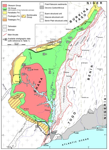
It is located on the West African Shield made of Archean and Palaeoproterozoic rocks, stabilized since about 2 Ga. The West African Craton is exposed in two separate units – the Reguibat Ridge in the North and the Man or Leo Ridge in the South – which are separated by thehuge Neoproterozoic and Palaeozoic Taoudeni basin.At its northern, western and southern margins,the Volta Basin unconformably overlies the Man or Leo Ridge Birimian basement, that consists mainly of rocks deposited in volcano-sedimentary basins, intruded by abundant granitoids between 2215 and 2060 Ma during the Eburnean orogeny. To the East, the Volta Basin is bordered by the front of thrusted rocks that represent external units of the Pan African Belt related to Dahomeyide orogenic event. Different structural units, separated by thrusts, are usually distinguished within this Pan African Belt, with from west to east (Fig. 1):
(i) the Buem Formation that consists of a thick, lower sequence of clastic sediments with some carbonate and tillite units succeeded by clastics and volcanics that include mafic flow units and pyroclastics (Kesse, 1985);
(ii) The Togo Serie (or Attacora in Benin and Akwapimian Serie in Ghana) that consists of quartzites, quartzitic sandstones, psammites, conglomerates, phyllites andmicaschists.Rocks are considered to be more metamorphic and more deformed than those of the Buem Formation, with a degree of metamorphism and deformation increasing towards the southeast.
Fig. 1. Geological map of the Volta Basin and surroundings, after Sougy (1970) and Affaton et al. (1980), with location of area studied in this paper and approximate locations of available stratigraphic data.
Internal units of the Pan African Belt are observed east to a complex zone (considered as a suture zone) containing rocks of various origins (ancient sediments of the West African margin, magmatic bodies emplaced and cooled down at the base of the continental crust, continental arc floor, and ancient fragments of Eburnean basement), some of which were subjected to eclogite or granulite facies metamorphism (Affaton, 1990; Attoh, 1990, 1998; Trompette, 1994). The internal zone corresponds to the structural unit of the Benin Plain (Fig. 1), comprising diverse units including granitoids, migmatites, undifferentiated gneisses, metasediments, orthogneisses and basic to ultrabasic rocks.
Lithostratigraphy of the Voltaian deposits
The thick sedimentary succession of the Basin is usually subdivided in three main megasequences separated by two major unconformities. These megasequences are often referred to three different groups, the terminology of which varies between authors (Figs. 1 and 2). Here, we employ the terminology of the three groups as currently used in Ghana (with alternatives in parentheses), the Bombouaka (or Dapango-Bombouaka), the Oti (or Pendjari), and the Obosum (or Tamalé) Groups.
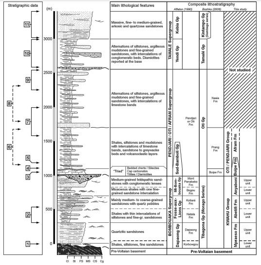
Fig. 2. Synthetic lithologic section of the Volta Basin sedimentary infilling, indicating approximate locations of available stratigraphic data (numbers referred to Fig. 1) with regards to main lithostratigraphic subdivisions. Granulometry: Cl, Claystone; St, Sitstone; FS, Fine-grained sandstone; MS, medium-grained sandstone; CS, Coarse-grained sandstone; Cg, Conglomerate. Sedimentary structures: see legend in Fig. 3.
The Bombouaka Group and its lateral equivalent (the Kwahu Group) in the Kwahu Plateau area
This unit consists of an alternation of quartzitic, conglomeratic or feldspathic sandstones and shales, the total thickness of which is about 1000 m.
Oldest Voltaian deposits are recognized in four main areas of exposure: the Gambaga Massif to the North, the Damongo and Kintampo Massifs to the West, and the Kwahu Plateau to the South. In all areas, first Voltaian deposits are supposed to be laterally equivalent and could therefore be ascribed to the Bombouaka (or Dapango-Bombouaka) Group. However, recent terminologies proposed by Carney et al. (2008a,b, 2010) distinguish:
(i) the Bombouaka Group along the northern (Gambaga Massif) and western (Damongo Massif) margins of the Volta Basin;
(ii) the Kwahu Group along the southern margin (Kwahu Plateau).
For the sake of clarity and demonstration, the subdivision into Bombouaka and Kwahu Groups – the relevance of which will further be discussed – is maintained in this paper.

Fig. 3. Synthetic lithologic section of the Kwahu Group in the studied area: lithostratigraphic subdivision, sampling location for palynological analysis, facies association composition, sedimentary environment evolution and sequence stratigraphy. Sedimentary structures: 1, Horizontal bedding; 2, Low-angle, planar cross-bedding; 3, Trough cross-bedding; 4, Planar cross-bedding; 5, Load casts, slumps; 6, Current ripples; 7, Hummocky cross stratification; Wave ripples. Sedimentary environments: offshore/shoreface, lower/upper offshore/shoreface; Cont., continental; Ext./Int. Delta, External/Internal delta. Key surfaces for sequence stratigraphy: SB, Sequence boundary; MFS, Maximum Flooding Surface; FS, Flooding Surface; DS, Downward Shift.
Along the northern and the western margin of the Volta Basin, the subdivision of the Bombouaka Group in different formations, as defined and regionally identified by Affaton (1990), has been used since by all geologists. Conversely, published maps of the southern margin adopt different terminologies and lithostratigraphic subdivisions for the Kwahu Group (Mason, 1963; Moon and Mason, 1967; Saunders, 1970; Brantuoh, 1991; Carney et al., 2008a, 2010).
At the northern and western margins of the Volta Basin, Bombouaka Group deposits are interpreted to result from sedimentation in a shallow epicontinental marine platform (Drouet, 1986; Affaton, 1990) in a stable tectonic setting. Structural, petrographic and sedimentological features suggested that source rocks for the Bombouaka and Kwahu Groups were located in the Leo Shield to the west. On the Kwahu Plateau, Anani (1999) analyzed the geochemical composition of some sandstones belonging to the Kwahu Group, and suggested that (i) source rocks were mainly of plutonic origin with associated metasediments, (ii) sediment supply derived from both transitional continental and craton interior provenances, and (iii) sedimentation took place in a passive margin setting.
The Oti Group
The Oti (or Pendjari) Group, about 2500 m thick, unconformably overlies the Bombouaka–Kwahu Group. First deposits of the Oti Group constitute a highly distinctive basal sequence comprising tillite, carbonate and fine-grained cherty sediments (silexite). This association, usually called the ‘Triad’, is correlated in many of the West Africa Neoproterozoic successions (Bertrand-Sarfati et al., 1991). It is usually accepted that the tillite located at the base of the Oti Group, attests a worldwide glacial event, the Marinoan glacial event(Hoffman, 2005). The Cap Carbonate/Dolostone is interpreted as a marker of a peritidal palaeoenvironment and records a marine transgression event that occurred just after the tillite deposition (Porter et al., 2004; Nédélec et al., 2007).
Above this distinctive Triad, the Oti Group is mainly represented by a thick succession of claystones, siltstones, mudstones, less mature sandstones and greywackes, with locally intercalations of thin volcanoclastic and phosphorite layers. Depending on the dominant facies composition, previous authors defined different formations and members, the correlation of which remains difficult without precise stratigraphic markers.
This thick succession has been interpreted as flysch-like sediments deposited in a deeper marine environment on a passive continental margin and locally supplied by sediments derived from penecontemporaneous basic volcanism.
The Obosum Group
The Obosum (or Tamalé) Group, of dominantly sandstone composition, crops out in the central part of the Volta Basin. It consists mainly of reddish, coarse-grained to conglomeratic, polymictic sandstones, some of which have been interpreted as possible fluvioglacial deposits, with intercalations of red shales, siltstones and calcareous horizons. The top of the group is represented by massive quartzitic sandstones.
The Obosum Group is interpreted as molassic deposits coming from uplift and erosion of the Pan-African Belt, with sediment supplies from east to west. An internal progressive unconformity, lined by polymictic conglomerates of possible fluvio-glacial origin, attests, according to Deynoux et al. (2006), the westward migration of the depocenter, and intermittent uplifts of the Pan-African domain. The Volta Basin is thus interpreted for this period of deposition as a foreland basin.
Source: New sedimentological and biostratigraphic data in the Kwahu Group (Meso- to Neo-Proterozoic), southern margin of the Volta Basin, Ghana: Stratigraphic constraints and implications on regional lithostratigraphic correlations. Renaud Couëffé, Marco Vecoli.Precambrian Research 189 (2011) 155–175.
Следующий Бассейн: Luangwa Rift