Тип бассейна:
Подтип бассейна:
Класс бассейна:
Возраст бассейна:
Тип полезных ископаемых:
Геологический возраст начало:
Геологический возраст конец:
Площадь: 855132.44 км²
Williston Basin
The Williston Basin forms the southeastern extremity of the Western Canada Sedimentary Basin. It is the archetypal intracratonic basin, and its significant reserves of hydrocarbons have made it a major exploration region. Consequently, more than 20 000 exploratory boreholes have been drilled, and these provide a relatively large subsurface geological database. Approximately four fifths of these wells have been drilled in the Canadian part of the basin.
The basin is bordered to the east by the Sioux Arch of the Dakotas and southeastern Manitoba, and to the north by the Punnichy Arch fronting the Saskatchewan monocline. The latter rises at a rate of 2 to 4 m/km northeastward onto the Severn Arch of central Manitoba. The western limit is the Sweetgrass Arch of northern Montana and southeastern Alberta. The structural definition notwithstanding, sedimentary strata of the Williston Basin were laid down in greatly expanded versions of the present basin. These expansions were countered by flanking uplifts and peripheral stripping of strata, imprinting the present configuration on the basin (Fig.1).
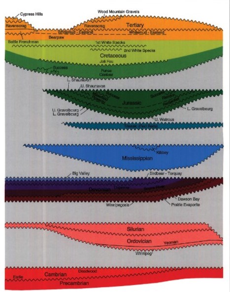
Fig.1. Unconformity-bounded slices of the Phanerozoic succession in the northern Williston Basin, schematically demonstrating the relative extent of basin enlargement and the effect of peripheral stripping. Note specifically the expanded distribution of Devonian strata in the Elk Point Basin/ The vertical component is the thickness for each slice. The net effect is that the Phanerozoic isopach map resembles the structural map.
Origin of the Williston Basin
There are two main aspects to the origin of the Williston Basin: 1) the mechanism of subsidence, and 2) the controls on the geographic positioning of the basin.
Mechanism of Subsidence
Quinlan (1987) evaluated five mechanisms of subsidence for intracratonic basins, categorized as: 1) a purely thermal process in which lithospheric layers expand and are uplifted during heating, and contract and subside upon cooling; 2) a variation on (1) in which the uplifted crustal rocks undergo erosion prior to the initiation of cooling and subsidence; 3) a second variation on (1) resulting in active rifting and thinning of lithospheric rocks by subcrustal erosion through the action of convection cells within the asthenosphere; 4) metamorphic tranformation of sublithospheric rocks resulting in their densification; and 5) horizontal compressive stresses acting upon pre-existing downwarps, the stresses being transmitted into the interior of the craton from convergent plate margins. Quinlan nonetheless identified deficiencies in each of the mechanisms, particularly where applied to the subsidence histories of the intracratonic basins of North America.
The complex patterns of stratal thickening, thinning and truncation in the sedimentary succession of the Williston Basin, as demonstrated in this and other chapters of this Atlas, may be responses to a combination of mechanisms causing basin subsidence and uplift of the flanking arches. A brief review of the pertinent geological and geophysical information may help to explore this premise. Hajnal et al. (1984) and Morel-a-L'Hussier et al. (1987) showed that a relatively thick crust underlies the basin. Fowler and Nisbet (1985) attributed this crustal thickening to a gabbroic to eclogitic phase transformation of the lower crust. They suggested that the phase change resulted in densification, loading and downward warping of the crustal rocks, creating an ellipsoidal depression. However Morel-a-L'Hussier et al. (1987) also identified a slight thinning (3-5 km) of the crust beneath the central portion of the basin. This evidence corroborates the findings of Crowley et al. (1985) who, through fission-track analysis of apatite, concluded that the Williston Basin had undergone uplift through thermal expansion followed by subaerial erosion, which resulted in the removal of at least 3 km of crustal rocks. This event is dated 572 Ma to 441 Ma (i.e., Early Cambrian to Late Ordovician), and thus may have initiated the basin as a depocentre in North Dakota (Peterson and MacCary, 1987; Lefever et al., 1987). Subsequent cooling may have prolonged basin subsidence through the Ordovician and Silurian and its sphere of influence extended by densification of the subcrustal rocks. Later downwarping may have been perpetuated by horizontal compressional stresses propagated through the cratonic crust from convergent margins (Quinlan, 1987). Doborek et al. (1991) demonstrated that emplacement of the Antler allocthon influenced sedimentation patterns in the Idaho-Montana region as early as the Givetian, and thus may account for the increased rate of subsidence in the basin from Late Devonian through Carboniferous, as recognized by Kominz and Bond (1991).
One of the areas flanking the Williston Basin that has undergone marked vertical fluctuations is the Swift Current Platform. Collerson and Lewry (1985) identified probable anorogenic granites in the Precambrian basement of this area. Klein and Hsui (1987) proposed that the emplacement of anorgenic granites at the flanks of intracratonic downwarps causes thermal arching of the crustal rocks, thereby enhancing the arch to downwarp relation. Emplacement of anorgenic granites in the basement rocks of the Swift Current Platform may have been a factor contributing to its tectonic restlessness.
Control on the Geographic Positioning of the Basin
Despite the low number of deep wells that penetrate the basement, various researchers have speculated on its nature. Meek (1958) interpreted the basement as being composed of three structural provinces, the boundaries of which are not totally in concert with those accepted today. More recently, Green et al. (1985) partitioned the basement beneath the basin and the Sweetgrass Arch into three Archean provinces, Superior in the east and Wyoming and Churchill (Hearne) in the west, with an intervening Lower Proterozoic collision zone separating the first from the latter two (Fig. 2). They recognized the collision zone as the southern extension of Lewry's (1984) Trans-Hudson Orogen, a continent-to-continent collision suture. Green et al. (1985) demonstrated that several lithotectonic belts and juvenile terranes make up the collision zone. In addition, the north-trending structural grain of the orogen is mimicked by southern extensions of the Tabbernor and Thompson Boundary faults of the exposed Canadian Shield. Hoffman (1989) interpreted the southwestern part of Saskatchewan to be underlain by a separate terrane, the Medicine Hat Block, possibly a component of the Hearne (Churchill) Province. This block constitutes a significant part of the Swift Current Platform.
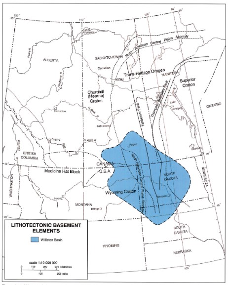
Fig. 2. Lithotectonic basement elements identified from geological, geophysical, geochronological data (after Green et al., 1985, Hoffman 1989).
f indeed the foregoing geological interpretations are valid, they may be sufficient reason for the location of the Williston Basin. The abnormal protrusion of the crust into the mantle beneath the basin (Hajnal et al., 1984) may be attributed to the nature of the convergence that created the Trans-Hudson Orogen, and that thickened mass may have been the catalyst for initial basin subsidence. Thus the east-west orthogonal fractures of the basin centre appear to be controlled by the Trans-Hudson Orogen. Likewise, the north-south orthogonal fractures may have been determined by the basin's location at the distal end of the Belt-Big Snowy aulacogen (Stewart, 1972), in which are preserved over 7 km of the Precambrian Belt Supergroup. Additionally, periodic reactivation of the aulacogen during the Phanerozoic, especially in the Cambrian, Mississippian and Jura-Cretaceous has taken place (Fig. 3). Thus it would appear that structural features, activated at different periods in the Proterozoic, played significant roles in the geographic positioning of the Williston Basin during the Phanerozoic.
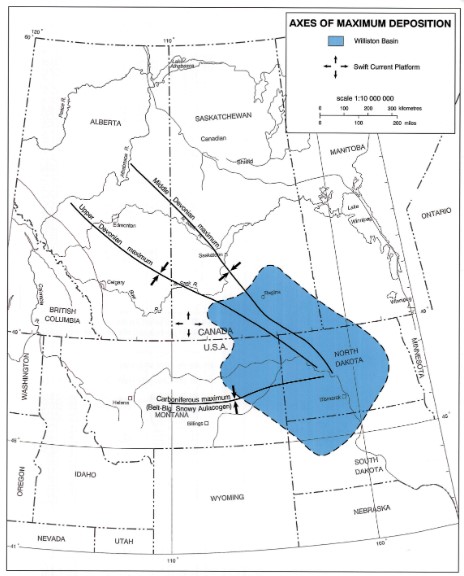
Fig. 3. Middle Paleozoic axes of maximum sediment thickness in the northern Great Plains (after Kent, 1987)
Bakken Mudrocks of the Williston Basin, World Class Source Rocks
Bakken mudrocks are extremely important source rocks for the Bakken petroleum system of the Williston Basin. Published estimates of oil generated from the source rocks range from 10 to 400 billion barrels.
The mudrocks are variable in mineral composition and total organic carbon content. The dominant minerals present are quartz, feldspar, pyrite, dolomite, and illitic clay. The quartz is both detrital and biogenic in origin. Recognizable biogenic components in the mudrocks include: conodonts, fish bones, radiolaria (recrystallized), large algal spores (tasmanite), small cephalopods, small brachiopods, small corals and ostracodes. Thin black limestones are locally present in the lower Bakken mudrock. A thin siltstone interval is also locally developed in the lower part of the lower Bakken mudrock.
TOC content appears to vary inversely with percentage of biogenic silica (radiolarian). The TOC content of the mudrocks averages 11 wt%. The type of kerogen present is largely Type I/II based on visual and pyrolysis analysis. The mudrocks are red to brown in color where immature and black where mature. The mudrocks appear to be mostly finely laminated but small ripple forms are also present indicating bottom current activity. The mudrocks were deposited largely under anoxic conditions probably due to density stratification of the ocean water column in a restricted basin setting. Some burrowing has been reported in the mudrocks suggesting times of more oxic conditions.
Knowledge of petrophysical properties, TOC content, organic facies, mineralogy, fracturing, source rock maturity of the Bakken mudrocks are important to the understanding of hydrocarbon occurrence and distribution in the Bakken petroleum system.
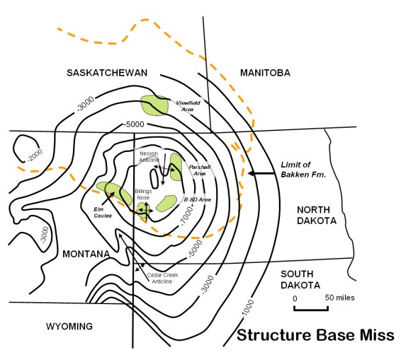
Fig. 4. Index map of the Williston Basin illustrating the structure at the base of the Mississippian. The limits of the Bakken are shown by the dashed line. Recent giant discoveries (the past 10 years) include Elm Coulee of Montana, Parshall area of North Dakota, and the Viewfield area of Saskatchewan.
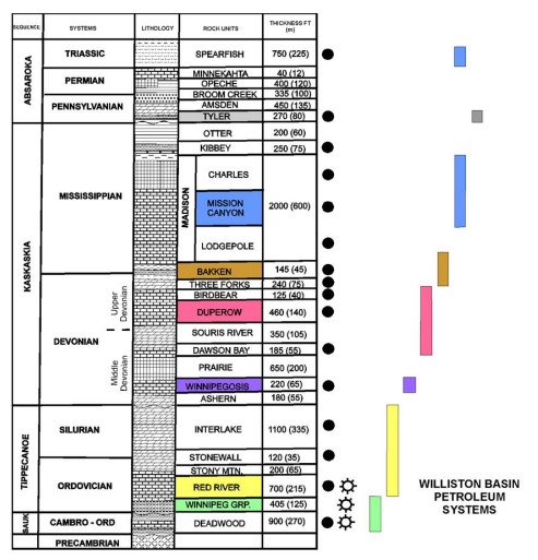
Fig. 5. Stratigraphic column for Paleozoic and Lower Mesozoic units of Williston Basin. Also shown are extents of various petroleum systems. The Bakken petroleum system consists of reservoirs in the lower Lodgepole, Bakken, and upper Three Forks and source beds in the Bakken. Modified from LeFever et al., 1991 and Anna, 2010.
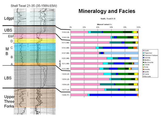
Fig. 6. Well log (gamma-ray and resistivity) of Shell Texel Bakken petroleum system interval (Sec. 35-T156N-R93W). Mineralogy (XRD) of Bakken shown in chart to right. The middle Bakken can be subdivided into at least six distinct facies. Current targets of horizontal drilling are the middle member of the Bakken and the upper Three Forks.
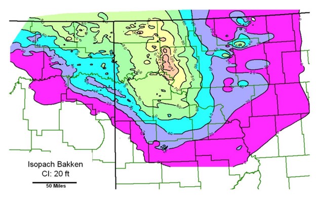
Fig. 7. Isopach map of Bakken Formation, U.S. part Williston Basin. Thickness ranges from wedge-edge to over 140 ft.
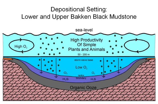
Fig. 8. Deposition setting of upper and lower Bakken shales under anoxic conditions (modified from Smith and Bustin, 1996; Meissner et al., 1984).
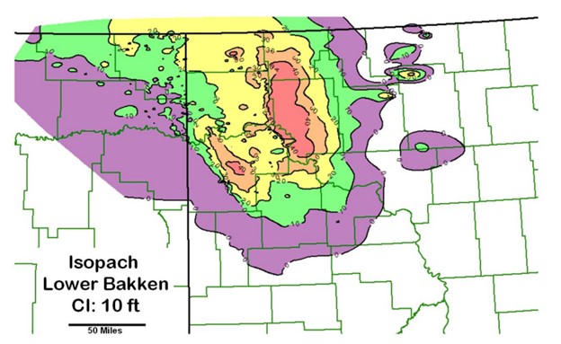
Fig. 9. Isopach map of lower Bakken shale. Thickest area is east of the Nesson anticline and generally coincides with the Parshall area.
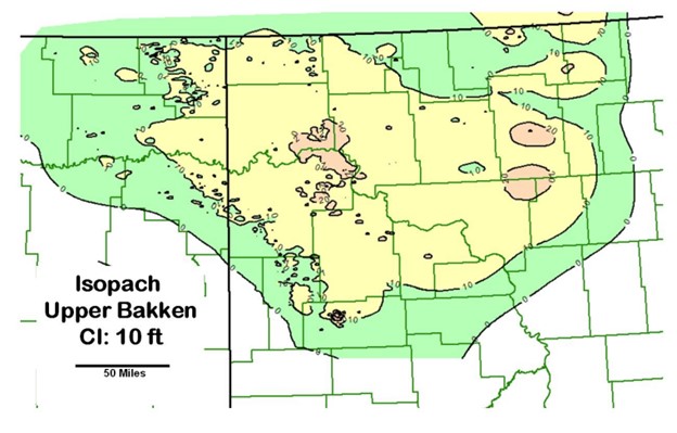
Fig. 10. Isopach map of upper Bakken shale. Thickness ranges from a zero edge to over 20 ft.
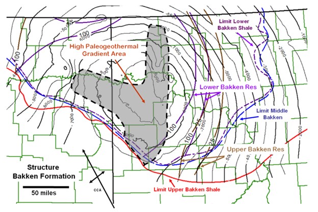
Fig. 11. Structure map top Bakken showing limits of upper Bakken shale, middle Bakken, and lower Bakken shale. Also shown are iso-resistivity lines for the upper and lower Bakken shales from Hester and Schmoker (1985). The shaded area is a high paleogeothermal gradient area modified from Price et al. (1984).
Data source: Chapter 27 - Geological History of the Williston Basin and Sweetgrass Arch. D.M. Kent - University of Regina, Regina J.E. Christopher.
Bakken Mudrocks of the Williston Basin, World Class Source Rocks. Stephen A. Sonnenberg, Hui Jin, J. Frederick Sarg. 2011
Следующий Бассейн: Hudson Bay