Класс Месторождения: Крупное
Тип Месторождения: Нефтяное
Местоположение:
Местность:
Стадия разработки: Доразведка
Год открытия: 2017
Источник информации:
Метод открытия:
Площадь: 4.24 км²
Eridu oil field
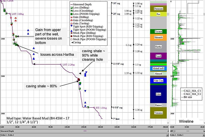
Eridu oil field was discovered in Mishrif B formation after drilling the first exploration well Eridu-1 (3168 m MD, 3150 m TVDSS). Many drilling problems were encountered while drilling Eridu-1 and the operation deviated from the planned program as shown in (Fig. 1).
Fig. 1. Example from Drilling Operation Problems in Exploration Well ER-1
The Eridu oil field within the area in the South-West part of the Republic of Iraq, on the boundary between the Thi-Qar and Muthanna Provinces, at 120 km to the West from Basra, 150 km to the West from the West Qurna-2 oilfield as shown in (Fig. 2).

Fig. 2. Block 10 (Eridu oil field) Location Map
The total field area is 5665 square kilometers (before expansion). In accordance with the approval of the Ministry of oil (MoO) regarding expansion of the Block 10 Contract Area for 141 sq. km, the new area of Block 10 is 5806 sq. km.
Geological and Tectonic Settings
Eridu oil field is located in the Mesopotamian Foredeep (Fig. 3). It is the terrestrial remnant of the Zagros foreland basin, that extends southeast to its marine counterpart "The Arabian Gulf". It is located between the stable continental part (i.e., the Inner Platform) and the Zagros Mountain front to the northeast. It contains many buried structures including neotectonically active ones. Based on its different mobility and activity, the Mesopotamia foredeep is subdivided into Al-Jazira and Basra subzones in the north and south respectively (Fouad,2012). The Mishrif Formation represents a heterogeneous formation originally described as organic detrital limestones, with beds of algal, rudist, and coral-reef limestones, capped by limonitic freshwater limestones.
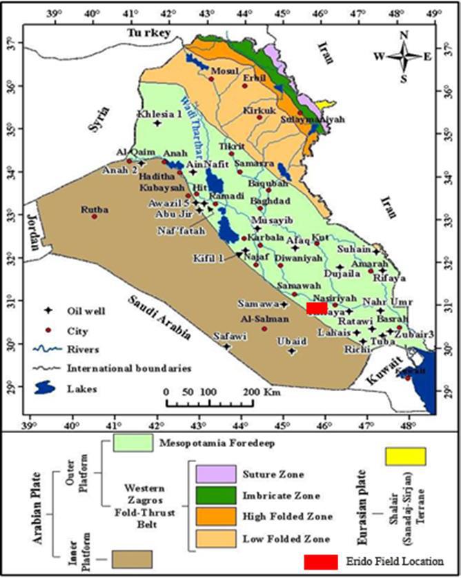
Fig.3. Tectonic map of Iraq and the location of Eridu oil field (after Fouad, 2012).
The Mishrif Formation is considered one of the main important reservoirs in southern Iraq. The formation was deposited in the early part of the Late Cretaceous period, and it is considered with the Kifl, Rumaila, and Ahmadi formations a major sedimentary cycle representing the age (Cenomanian- E. Turonian), where the upper boundary of the Mishrif Formation represents a conformable surface with the Kifl Formation, and the lower boundary also represents a conformable surface with the Rumaila Formation. Due to the importance of the formation, this study focused on the stratigraphic and reservoir phenomena in it, as it represents the most important exploratory goal in this sedimentary cycle. The Mishrif Formation is a regressive sequence of deposition within the secondary cycle of Cenomanian-Early Turonian sedimentary, which began with the interruption of the deposition of the Mauddud Formation and the emergence of a regional unconformity surface for the top formation (Sharland et al., 2001), in which the Rutbah Formation was deposited in the western parts from the basin while the Ahmadi and Rumaila formations were deposited in the eastern parts in the marine inundation conditions during of the Transgressive Conditions, consisting of limestone, calcareous clay and shale rocks with the presence of planktonic foraminifera and calcispheres fossils. The sediments of this phase adopt the depositional pattern known as retrogradation sequence. This was followed by the deposition of the Mishrif Formation in shallow marine environments. In the later stages of this cycle, the evaporative Kifl Formation was deposited in the deep parts of the basin, as it formed a cover of evaporite rocks above the Rumaila Formation and sometimes above the Mishrif Formation. This sedimentary cycle ended with the emergence of a middle Turonian surface separating the Khasib Formation from the Kifl Formation or the Mishrif Formation.
The period that the Arabian Plate, which extends from the middle of the Cretaceous until the end of Maastrichtian, represents a transitional stage and transformation from a tension tectonic system to a compressional tectonic system as a result of the convergence between the Arabian Plate and the adjacent plates with it. This convergence resulted in the subduction of the Oceanic Crust of the Arabian Plate, under the marine crust of the two neighboring blocks (Iranian and Turkish), and these two blocks together formed the Eurasian Plate. Burchett, (1993) indicated that the subduction of the marine crust under the Eurasian Plate was accompanied by the emergence of a structural rise (Uplift) along the southeastern edge of the Arabian Plate, which contributed to the formed of a developed platform (the Mishrif Formation platform), where the structural factor contributed to the beginning of age (Cenomanian) through the subduction of the oceanic crust of the Arabian Plate, below the oceanic crust of the Eurasian Plate, to the emergence of a structural uplift along the southeastern edge of the Arabian Plate, which contributed to the formation of the Mishrif Formation platform in the form of an arch, on which facies were distributed of the Mishrif Formation, which formed the Rudist barrier under Highstand Conditions (Burchette & Wright, 1992), (Fig.4).
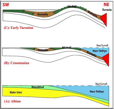
Fig.4. Stages of development of the Arabian plate according to (Burchette & Wright,1992).
Data source: A Comprehensive Geomechanical Study to Understand Drilling Challenges in the Eridu Oil Field, Southern of Iraqю. Ahmed T. Kareem, Faleh H.M. Almahdawi, Ghareb M. Hamada. Iraqi Journal of Chemical and Petroleum Engineering 25, 2 (2024) 73 – 83
Depositional and Stratigraphic Evolution of the Mishrif Formation in Eridu Oil Field, Southwestern Iraq Mohammed A. Al-Mashhdani and Aiad A. Al-Zaidy. Iraqi Geological Journal. 2023, 56 (1E), 22-42
Следующее Месторождение: BUTTONWILLOW GAS (ABD)