Publications by the American Association of Petroleum Geologists over the past three decades have identified 500 to over 900 oil fields as world-class “giants;” those with proven oil reserves of 500 million barrels or natural gas reserves of 3 trillion cubic feet. A “supergiant field” is one with 5 Bbo (or oil equivalent) reserves. Despite their relatively lower population, the giant fields account for over half of the world’s oil resources. Their distribution, however, is uneven; over 200 of them are concentrated in the Persian Gulf region. Giant fields are hard to come by, and the life span and reservoir management of these fields will have a drastic impact on the global oil industry and market in the coming years. Starting with this issue, Geo Expro will occasionally present reviews on the world’s giant oil and gas fields. And it is apt to begin the series with the world’s largest of its kind – the Ghawar field in Saudi Arabia.
Discovered in 1948 and located some 200 km east of Riyadh, Ghawar has produced about five million barrels of oil per day in the past three decades. Last year, output from Ghawar accounted for 62.5% of Saudi Arabia’s crude production (about 8 MMbopd) and 6.25% of the world’s total oil production (about 80 MMbopd).
 A historical photo showing the exploration of the Ghawar field in the late 1940s. Photo courtesy of Saudi Aramco CoThe Ghawar field is located in Khobar County in the Eastern (Al Hasa) Province; it is about 100 km southwest of Dhahran (Saudi Aramco’s headquarters). The field is an almost north-south trending structure, 280 km long and 30 km wide on average, totaling an area of 5,300 km2 – about one fourth the size of Wales or New Jersey. Of course, not the entire field is productive; Alsharhan and Kendall in their 1986 paper in AAPG Bulletin give a figure of 2,800 km2 for the productive area of Ghawar.
 >
>
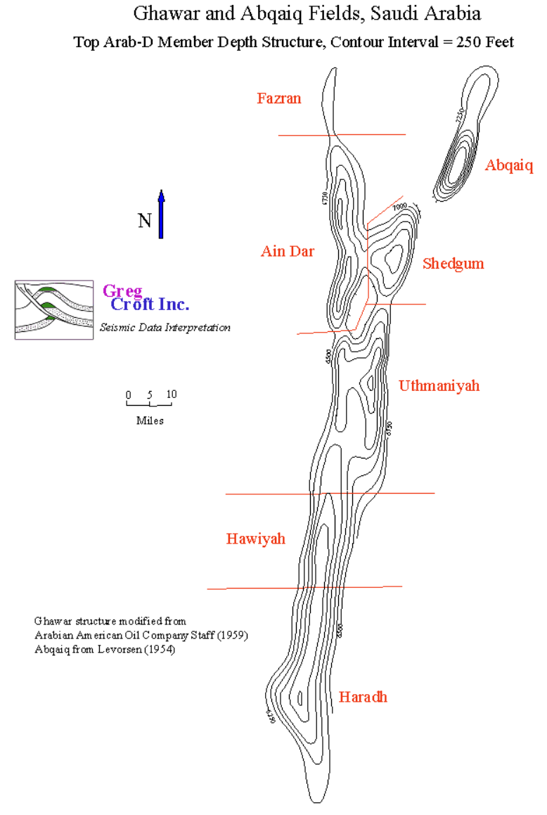
The field is divided into six parts, corresponding to prominent structural culminations; from north to south they are Fazran, Ain Dar, Shedgum, Uthmaniyah, Haradh, and Hawiyah. Because of secrecy over data held by Saudi Aramco, detailed information about the Ghawar field is not available in the public domain; one thus has to piece together data from the official reports or published research works to characterize the geology, reserves and production history of Ghawar.
-

A view of the Haradh gas-oil separator plant shows the extent of this giant field. The plant went onstream in 2003, Saudi Aramco’s second plant to process non-associated gas. It is designed to process 1.6 Bcfgpd from wells in the South Ghawar and produce 1.5 Bcfpd of sales gas and 170,000 bpd of condensate. Photo courtesy of Saudi Aramco
Field Discovery: The Magnificent Five
The discovery and development of the Ghawar field dates back to the 1940’s and 50’s, when the Standard Oil of California (Socal, forerunner of Arabian American Oil Company, later Saudi Aramco) obtained concessions from the Saudi government for oil exploration in the kingdom. These activities resulted in the discovery of Dammam in 1938, and Abu Hadriayh and Abqaiq in 1940 (see “The Emergence of the Arabian Oil Industry”).
-

A structural transect across the Ghawar field (Modified after A.M. Afifi, 2004 AAPG Distinguished Lecture)
In 1940, while the company was drilling the Abqaiq prospect, one of its young geologists, Ernie Berg, was mapping the nearby areas and noted that the Wadi Sahaba, a dry river bed in the Haradh area, took a sudden bend from its east-west course to the south. He hypothesized that a north-south trending subsurface anticline was responsible for this wadi diversion. His boss, the renowned geologist Max Steineke, agreed with the idea. Further mapping confirmed the existence of what came to be called the En Nala (“the Slippers”) anticline. What made mapping this anticline possible was shallow structural-stratigraphic drilling, down to about 300m in the desert, a technique Steineke had developed to map the subsurface geology and collect pre-Neogene information in the region.
World War II hampered all these activities, but once the war ended in 1945 and exploration resumed the En Nala anticline drew attention again. Shallow drillings were supplemented with gravity and magnetic surveys. In 1948, a test well was drilled at Ain Dar, which hit oil, the first post-war discovery in the country. Steineke then proposed a second drill site at Haradh, about 185 km south of Ain Dar. This wildcat also discovered oil in 1949. Then came Uthmaniyah No. 1, drilled in 1951, Shedgum No. 1 (1952) and Hawiyah No. 1 (1953), all of which discovered oil from the same Upper Jurassic carbonate reservoir at depths of 2,000-2,330m along the same anticline. By 1953, it was recognized that all these prospects were parts of a single field that was named Ghawar, after the pasturage area the local Bedouins originally called Al Ghawar. (Some geologists argue that these structural culminations are separate fields, but here we follow the conventional history and regard them as parts of the Ghawar supergiant field).
An article in the 2008 fall issue of the Saudi Aramco Dimensions magazine provides valuable information about these five discovery wells dubbed by the authors of that article as “The Magnificent Five” (see Table 1). Except for the Uthmaniyah No. 1, the other discovery wells are still productive.
The northernmost part of the Ghawar field, Fazran, was found in 1957 to have oil in the same reservoir, but our knowledge of this area remains quite limited.
Structural Setting
The En Nala anticline, on which the Ghawar field sits, is located within the Central Arabian graben. Drilling and seismic images show that the anticline (trending N15° E) itself sits on a basement horst formed during the late Carboniferous-Permian extensional tectonics and block uplift, probably related to continental rifting along the Arabia-Gondwana margin and opening of the Neo-Tethys Ocean. This basement horst was reactivated as a compressional structure during the Late Cretaceous, and the compressional stress has continued in the Cenozoic as the Arabian plate collided with Asia. Interestingly, the basement horst forms a divide between the Infracambrian salt deposits on its east and the Precambrian metamorphic rocks (devoid of the salt layer) on its west; therefore, the activity of the structures probably dates back to the Late Proterozoic “Pan African” extensional tectonics.
 >
>
The southern part of the En Nala structure is a relatively simple anticline with shallow (3-8°) dipping flanks; the anticline is asymmetrical having a steeper western flank. To the north, the structure becomes more complex.
-

Late Jurassic paleogeography showing the Ghawar field on the Arabian carbonate platform (Modified after Lindsay et al, AAPG Memoir 88, 2006
Major Jurassic Reservoir
The Ghawar area is largely covered with Miocene-Pleistocene continental sediments except for two small Eocene outcrops. The Tertiary and Cretaceous rocks have not yielded oil accumulations in this field; the producing reservoir is the Upper Jurassic Arab formation which is a major oil reservoir in the Middle East. The Arab-D reservoir in Ghawar includes the lowermost zone of the Arab formation and the uppermost part of the Jubaila formation. It is carbonate rock of Kimmeridgian age, as determined from its ammonite and benthonic foraminifer fossils, deposited on the shelf of the Neo-Tethys Ocean. The Ghawar area then lay about 5° south of the equator. The Arab and Jubaila formations are 186m and 400m thick, respectively, in Ghawar. The producing interval has been reported to be 50-100m.

Sedimentologists have further divided Arab-D carbonates into six lithofacies units, with the transition from the Jubaila to the Arab formation lying at Unit 2B, marked by karst-collapse breccias. Overall, the Arab formation sequence of the Arab-D reservoir consists of grainstones and packstones while the underlying Jubaila formation part is limestone and mudstones. The reservoir has retained good porosity, averaging 15%, in the form of interparticle, intraparticle and moldic pores. Fractures and interparticle pores provide the reservoir’s permeability. Dolomites also occur in Arab-D, and were probably formed by downward flow of magnesium-rich brines during deposition of Arab C and D anhydrites on the top. It has been recognized that units 2A and 2B of Arab-D are occasionally very high permeability zones (or “Super-k” intervals which intersect wells producing over 500 barrels per day per foot) and that such zones are associated with dolomites. Probably the process of dolomitization helps fracturing of the rock. For this reason, the characterization and mapping of dolomites in Arab-D has attracted much research work.
Available data from the discovery wells (Table 2) indicate that the reservoir quality of Arab-D becomes relatively poorer from north to south as reservoir thickness, porosity and permeability are progressively reduced; oil quality also appears to change as sulfur content and oil density increase.
Oil from Ghawar has a density of 30-34° API. The oil column in the field has been reported to be 396m. The oil-water contact in North Ghawar is about 137m deeper than in South Ghawar; this northward tilting of the oil-water contact has puzzled researchers for decades.
Oil is believed to have charged from the organic-rich, thermally mature bituminous carbonates and mudstones of the Hanifa and Tuwaiq formations (Upper Jurassic age). Anhydrites of Arab-D and C, with a thickness of 30-100m, provide cap rock for the accumulated oil in Arab-D.
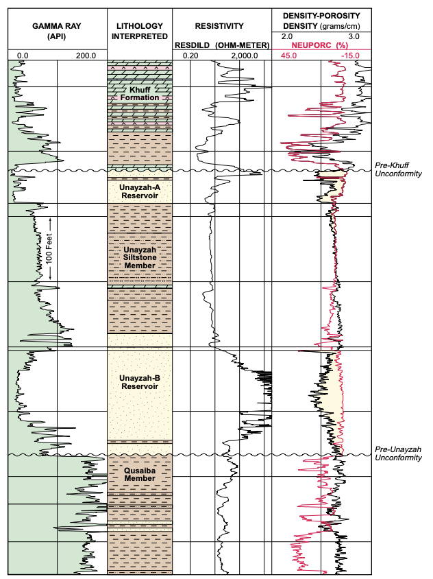
The major pre-Khuff hydrocarbon reserves discovered to date in the Ghawar Area are from the Lower Permian Unayzah Formation and the Lower to Middle Devonian Jauf Formation. The Unayzah Formation is the principal pre-Khuff hydrocarbon reservoir in the Southern Ghawar Area (Haradh, Sahba, Waqr and Tinat), while the Jauf Formation is the primary reservoir to the north (Hawiyah, ‘Uthmaniyah and Shedgum). The Unayzah Reservoir is generally divided into two units: the upper Unayzah-A Reservoir and the lower Unayzah-B Reservoir (Figure 7). These reservoir units are separated by a siltstone member, which is reddish to gray in color in the Southern Ghawar Area. This siltstone separator is well-developed in Southern Haradh, Sahba, and Tinat, but is poorly-developed to the north. The Unayzah is missing in Central and Northern Ghawar and thickens to the south. Thickness ranges from 0 ft in Southern Hawiyah to nearly 1,600 ft at Tinat, where a lower Unayzah unit (or its equivalent) is present beneath the Unayzah-B Reservoir. The Unayzah-A Reservoir has tested gas at Haradh, Sahba, and Harmaliyah. Premium crude oil occurs in the Unayzah-A at Tinat, and is the only oil occurrence thus far found in the pre-Khuff of the Ghawar Area. Porosities range from 5-25%, and average around 12% in the pay zones. Gas flow rates from the Unayzah-A Reservoir are highly variable, ranging from less than 5 mmcfgd to more than 40 mmcfgd. The Unayzah-B Reservoir has only flowed measurable gas in southern Haradh. Porosities in this well, and surrounding Unayzah-B penetrations, are generally low and average approximately 6%. Higher flow rates in the Unayzah-B are attributable to fracture-enhanced permeability. The Jauf Reservoir in the Ghawar Area is very well developed and displays unusually high porosities considering the depth of burial. The Jauf Reservoir is the productive pre-Khuff unit at Shedgum, Hawiyah, ‘Uthmaniyah, and Abu Safah fields. Log correlations of Jauf penetrations in the Eastern Province of Saudi Arabia show excellent reservoir development and continuity. The Jauf Reservoir ranges in thickness from 292 to 474 ft in the Ghawar Area. The type log for the Jauf Formation is shown in Figure 8. The Jauf can be crudely divided into two units based on log character. The lower unit is characterized by “cleaner” looking sands on the gamma-ray, with few shale-siltstone intercalations. The upper unit is characterized by “dirtier” looking sands (higher gamma-ray), with several shale intercalations. Both fining- and coarsening-upward sequences are evident in the upper unit. Reservoir quality is best developed in the upper unit at Ghawar. As noted previously, the Jauf Reservoir lacks the silica cementation that is so prevalent in other preKhuff siliciclastic units. The reservoir sands are weakly-cemented with authigenic illite clay, which occurs as grain coatings, as well as pore lining and bridging filaments (Cocker and Al-Shahab, 1995, unpublished report). The illite grain coatings have inhibited quartz cementation, and is primarily responsible for the preservation of high porosity in these deeply-buried sandstones. The abundance of dispersed illite in the reservoir sands has a significant effect on wireline log responses, and, if not accounted for, can lead to pessimistic formation evaluations (Figure 8). Among these potential “pitfalls’” is the lowering of resistivity values due to the excess bound water and high cation exchange capacity of the illites. This can lead to pessimistic water saturation calculations and potentially bypassed low-resistivity pay zones. Sands with resistivities as low as 0.35 ohm-meters and Archie-derived water saturations as high as 65% have produced water-free hydrocarbons in the Jauf Reservoir.
Additionally, the presence of illite in the sands increases the gamma-ray response due to the potassium,
which makes the sands look “dirtier”. An additional log evaluation “pitfall” caused by the presence
of illite is the suppression of the “gas effect” noted on neutron-density logs. This suppression of the
neutron-density curve crossover is caused by the higher apparent neutron porosity due to the abundant
bound water and correspondingly high hydrogen index associated with the illite.
The Jauf Reservoir is host to the recently discovered giant gas-condensate field at Hawiyah, and is
also the productive pre-Khuff gas reservoir at Shedgum, ‘Uthmaniyah, and Abu Safah. Porosities up
to 30% are observed in the Jauf Reservoir, which is extremely high considering the present-day depths
of approximately 14,000 ft. As noted earlier, the preservation of these high porosities is due to the
presence of illite grain coatings.

Trap Formation
Structural development and trap formation in the Ghawar Area took place in four distinct stages: the
Carboniferous stage associated with the Hercynian Orogeny; the Early Triassic stage associated with
the rifting along the Zagros suture and the opening of the Neo-Tethys sea; the Late Cretaceous stage
associated with the collisional event that led to the emplacement of the Semail Ophiolite Complex in
Oman (First Alpine Event); and the Middle to Late Tertiary stage associated with the opening of the
Red Sea and collision of Arabia with Eurasia (Second Alpine Event). Three structural cross-sections
illustrating the trapping configurations for pre-Khuff hydrocarbons in the Ghawar Area are shown in
Figures 9 to 11. The locations of these cross-sections are shown on the PUU subcrop map (Figure 5).
Interestingly, the eight structures studied in the Ghawar Area (Figure 2) show different growth histories.
Figure 12 is a summary chart of the individual structures in the Ghawar Area showing the differing
growth histories as well as the presence of associated gravity anomalies and hydrocarbons.
To evaluate these growth histories, a series of isochron, isopach and time structure maps of critical
horizons were generated using most of the available higher fold seismic data. The maps selected to
illustrate the four main growth periods include: Base Khuff to Base Qusaiba Isopach (Carboniferous Hercynian Event); Jilh Dolomite/Mid-Jilh Reflector to Top Khuff/Base Khuff Isochron (Triassic Zagros
Rifting Event); pre-Aruma Unconformity to Shu’aiba Isochron (Late Cretaceous First Alpine Event);
and Top Aruma Time Structure (Tertiary Second Alpine Event). The later time structure map was
selected because a consistent regional seismic pick on the pre-Neogene Unconformity (PNU) could
not be made. It is reasoned that the top of the Aruma Formation would have been deposited as a
relatively flat surface, and that significant relief of that horizon is attributable to the Middle-Late Tertiary
growth event.
 >
>
Palaeozoic Gas
Deeper drilling in the Ghawar field has discovered vast amounts of natural gas in the Palaeozoic sediments. These discoveries were made in 1971 (Haradh), 1975 (Ain Dar), 1979 (Hawiyah and Shedgum) and 1980 (Uthmaniyah). In 1994, Saudi Aramco began a vigorous plan for deep gas exploration including prospects in Ghawar.
The gas reservoirs include the Khuff Formation (Permian carbonates), the Unayzah Formation (Permo-Carboniferous fluvial-aeolian sands), and the Jauf Formation (Devonian coastal to shallow-marine sands). The payzones lie at depths of between 3,000 and 4,270m. A Silurian black shale (“hot shale” on gamma logs) called the Qusaiba Formation constitutes a major source rock for the Palaeozoic gas accumulations in the Ghawar field, as it does in other fields of central Saudi Arabia. This shale was deposited during a major sea-level rise in the Silurian.
According to Afifi (2004), gas production from Ghawar totals about 8 Bcfgpd, out of which 2 billion is associated gas and 6 billion is non-associated gas.
How much oil in Ghawar?
No one exactly knows how much oil lies beneath Ghawar. Some estimates (World Energy Outlook, 2005 and 2008) put the oil in place as high as 250-300 billions! However, simple calculations using the reservoir volume, porosity, and water saturation for all the five areas of Ghawar (Table 2) would give the maximum amount of oil in place at about 190 Bbo. How much of this oil (if true) is recoverable is another story. Total recoverable oil reserves from Ghawar have been reported variously as 75 Bbo (Halbouty et al., 1970, AAPG Memoir 14), 68-46 Bbo (Oil & Gas Journal issues 1973-77), 80.3 Bbo (Beydoun, The Middle East, 1988), 66 Bbo (Mann, 2003, AAPG Memoir 78), and 140 Bbo (World Energy Outlook, 2008). The latter source places the natural gas reserves of Ghawar at 186 Tcf, thus giving combined reserves of 97 Bboe.
Beydoun in his book (The Middle East, 1988) reports that Ghawar had produced 19 Bbo by 1979. According to an article on Ghawar in the AAPG Explorer (January 2005), the cumulative production from the field was 55 Bbo. The International Energy Agency in its 2008 World Energy Outlook states that the oil production from Ghawar reached 66 Bbo in 2007 and that the remaining reserves are 74 Bbo.
Data on Ghawar reported in the past issues of Oil & Gas Journal indicate that when Ghawar came on stream in 1951 it produced 126,000 bopd but production steadily rose with a major boost soon after the 1973 oil shock so that the field’s 1975 output was 4.2 MMbopd; this reached a maximum production of 5.7 MMbopd in 1981. From 1982-1990, the Saudis lowered their oil production for market considerations (most notably the oil crash of 1985) and thus Ghawar’s production was 2.5 to 3 MMbopd during that decade. A senior geologist with Saudi Aramco, A. M. Afifi, in his 2004 AAPG Distinguished Lecture, reported production values of 4.6-5.2 MMbopd for Ghawar from 1993 through 2003. These data indicate that 50-65% of Saudi Aramco’s oil production has traditionally come from Ghawar. Apparently, one half of Ghawar’s production (2.0 to 2.7 MMbopd) comes from the Ain Dar and Shedgum areas, while Uthmaniyah provides 1 MMbopd, and another million barrels or so comes from Hawiyah and Haradh combined.
Compared to the supergiant size of Ghawar, our public knowledge of this field remains insignificant. Oil fields, whether small or large and wherever they happen to be located, eventually come to an end, but giant fields have enormous life spans.
Ghawar Field, Ain Dar Area, Arab-D Reservoir Parameters, Saudi Aramco (1980)
Original OWC in Feet Subsea | 6430 to 6665 |
Average Net Thickness (Feet) | 204 |
Formation Volume Factor (RB/STB) | 1.34 |
Initial Solution Gas-Oil Ratio (SCF/Bbl.) | 550 |
Oil Gravity (Degrees API) | 34 |
Oil Viscosity at Reservoir Conditions (centipoise) | 0.62 |
Sulfur Content, by Weight | 1.66 % |
Average Porosity | 19 % |
Average Permeability (Millidarcies) | 617 |
Water Saturation (Original) | 11 % |
Average Productivity Index (BOPD/PSI) | 141 |
Ghawar Field, Shedgum Area, Arab-D Reservoir Parameters, Saudi Aramco (1980)
Original OWC in Feet Subsea | 6444 to 6689 |
Average Net Thickness (Feet) | 194 |
Formation Volume Factor (RB/STB) | 1.35 |
Initial Solution Gas-Oil Ratio (SCF/Bbl.) | 540 |
Oil Gravity (Degrees API) | 34 |
Oil Viscosity at Reservoir Conditions (centipoise) | 0.62 |
Sulfur Content, by Weight | 1.75 % |
Average Porosity | 19 % |
Average Permeability (Millidarcies) | 639 |
Water Saturation (Original) | 11 % |
Average Productivity Index (BOPD/PSI) | 138 |
Ghawar Field, Uthmaniyah Area, Arab-D Reservoir Parameters, Saudi Aramco (1980)
Original OWC in Feet Subsea | 6347 to 6570 |
Average Net Thickness (Feet) | 180 |
Formation Volume Factor (RB/STB) | 1.31 |
Initial Solution Gas-Oil Ratio (SCF/Bbl.) | 515 |
Oil Gravity (Degrees API) | 33 |
Oil Viscosity at Reservoir Conditions (centipoise) | 0.73 |
Sulfur Content, by Weight | 1.91 % |
Average Porosity | 18 % |
Average Permeability (Millidarcies) | 220 |
Water Saturation (Original) | 11 % |
Average Productivity Index (BOPD/PSI) | 92 |
Ghawar Field, Hawiyah Area, Arab-D Reservoir Parameters, Saudi Aramco (1980)
Original OWC in Feet Subsea | 6152 to 6576 |
Average Net Thickness (Feet) | 180 |
Formation Volume Factor (RB/STB) | 1.30 |
Initial Solution Gas-Oil Ratio (SCF/Bbl.) | 485 |
Oil Gravity (Degrees API) | 32 |
Oil Viscosity at Reservoir Conditions (centipoise) | 0.85 |
Sulfur Content, by Weight | 2.13 % |
Average Porosity | 17 % |
Average Permeability (Millidarcies) | 68 |
Water Saturation (Original) | 11 % |
Average Productivity Index (BOPD/PSI) | 45 |
Ghawar Field, Haradh Area, Arab-D Reservoir Parameters, Saudi Aramco (1980)
Original OWC in Feet Subsea | 6000 to 6620 |
Average Net Thickness (Feet) | 140 |
Formation Volume Factor (RB/STB) | 1.27 |
Initial Solution Gas-Oil Ratio (SCF/Bbl.) | 470 |
Oil Gravity (Degrees API) | 32 |
Oil Viscosity at Reservoir Conditions (centipoise) | 0.89 |
Sulfur Content, by Weight | 2.15 % |
Average Porosity | 14 % |
Average Permeability (Millidarcies) | 52 |
Water Saturation (Original) | 11 % |
Average Productivity Index (BOPD/PSI) | 31 |
http://www.gregcroft.com/ghawar.ivnu
 >
>
References
- Alsharhan, Abdulrahman S. and Kendall, Christopher G. St. C., Precambrian to Jurassic Rocks of Arabian Gulf and Adjacent Areas: Their Facies, Depositional Setting, and Hydrocarbon Habitat, Bulletin of the American Association of Petroleum Geologists, volume 70, #8, 1986 Arabian American Oil Company Staff, Ghawar Oil Field, Saudi Arabia, Bulletin of the American Association of Petroleum Geologists, Volume 43, #2, 1959
- Bramkamp, R. A., Sander, N. J., and Steinecke, M., Stratigraphic Relations of Arabian Jurassic Oil, Habitat of Oil, American Association of Petroleum Geologists, 1958 Levorsen, A.I., Geology of Petroleum, W.H. Freeman, San Francisco, 1954
- Mitchell, J.C., Lehmann, P.J., Cantrell, D.L., Al-Jallal, I.A. and Al-Thagfay, M.A.R., Lithofacies, Diagenesis and Depositional Sequence; Arab-D ember, Ghawar Field, Saudi Arabia,SEPM Core Workshop #12, Houston, 1988
- Saudi Arabian Oil Company, Impact of 3-D Seismic on Reservoir Characterization and Development, Ghawar Field, Saudi Arabia, AAPG Studies in Geology #42 and SEG Geophysical Developments Series #5, AAPG/SEG, Tulsa, 1996
- Saudi Aramco, Oil Reservoirs, Table of Basic Data, Year-End 1980
- United States Energy Information Administration, The Petroleum Resources of the Middle East, 1982