
Класс Месторождения: Крупное
Тип Месторождения: Газовое
Местоположение: Море
Местность:
Стадия разработки: Добыча
Год открытия: 1971
Источник информации:
Метод открытия:
Площадь: 133.9 км²
Kinsale Head field
The SW Kinsale gas accumulation is located in blocks 48/20 and 48/25, c. 50 km off the south coast of Ireland. The area lies at a water depth of some 100m in the North Celtic Sea Basin, SW of the main Kinsale Head Field and due south of the Ballycotton Field (Fig. 1). The field was discovered in 1971 by well 48/25-2, which encountered gas-bearing shelfal and fluviatile sandstones of Early Cretaceous Albian and Wealden age, respectively. Mapping of the available 2D seismic data suggested that the trapping geometry was a major mid-basin anticlinal structure, with caprocks provided by Lower Cretaceous shales (Colley et al. 1981). The dominant fault orientation that was mapped from these 2D data trends primarily in a NE-SW direction. Faults with both normal and reverse displacements were mapped throughout the area.
Fig. 1. Top Wealden formation depth structure of the SW Kinsale gas accumulation as mapped from 2D seismic data. The map shows the interpreted structural isolation of SW Kinsale, the gas-water contact (GWC) at -968 m TVDSS and the position of SW Kinsale 3D seismic survey. The yellow boxes denote defined field development areas for the Kinsale Head and Ballycotton fields. The inset map shows the general location of the fields.
Further appraisal drilling revealed that the Cretaceous section of the North Celtic Sea Basin comprises one overall transgressive sequence (Fig. 2). The mixed alluvial-fluvial-dominated systems of the Wealden sequence give way progressively to the more continuous shelfal sands, the Greensand, of Albian age. The deeper water Upper Cretaceous mudstones and chalks cap this succession. The results of appraisal drilling indicated that the higher quality and more continuous Greensand reservoir was best developed in the central and eastern portions of the Kinsale Head area. It is for this reason that gas production to date has been focused on these sectors of the field complex.
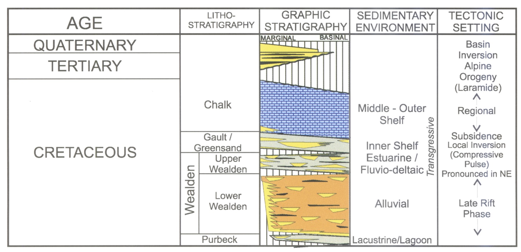
Fig. 2. Generalized Cretaceous-Recent lithostratigraphy, sedimentary environment and structural development of the North Celtic Sea Basin.
Depth mapping of the 2D data over Kinsale Head revealed a potential structural saddle between the main field and the SW Kinsale area (Fig. 1). In addition, these data suggested that the area was relatively unfaulted, and that well 48/25-2 had penetrated SW Kinsale close to the local structural culmination at Lower Cretaceous level. The objective of the present paper is to describe the regional setting and exploration history of the SW Kinsale gas accumulation. The results of a recent highresolution 3D seismic survey are described and discussed with a view to elucidating the size, structure and volumetric estimates of the field.
The SW Kinsale gas accumulation was discovered in 1971 with the drilling of well 48/25-2. This well encountered gas in both the Greensand and Wealden (Lower Cretaceous) reservoirs and was the discovery well for the Kinsale Head Field. The well tested dry gas from the Wealden sequence at rates of up to 0.57MMSCMD (million standard cubic metres per day). The field is thought to have been sourced from shales of Early Jurassic age (Taber et al. 1995).
Reservoir performance monitoring and simulation carried out by Marathon on the Kinsale Head Field in the early 1990s indicated that a potential volume of unswept gas might lie in the Wealden sandstones of the SW Kinsale area. This concept was supported by pressure differences, which had been observed between wells tested in the Wealden formation of the Kinsale Head Field. In addition, the complex architecture of the Wealden fluviatile systems, together with the potential structural isolation of the area, also supported the presence of an unswept accumulation.
The SW Kinsale area was further evaluated in 1995 with the drilling of appraisal well 48/25-3. This well, which twinned the original discovery well 48/25-2, was drilled close to the crest of the structure. As expected, the well encountered gas in the primary Wealden reservoir objective. The well was drillstem tested and flowed at rates of up to 0.66MMSCMD on a 2.86 cm choke. The gross reservoir interval, averaged over the two wells, measured some 23 m with an average net to gross ratio of 0.35. The average porosity encountered was 22% and repeat formation test (RFT) data revealed that these Wealden sandstones were close to virgin pressure. A minor drawdown of some 3.45 bar was observed and it is unclear if this is due to minor pressure communication with the main Kinsale Head Field or to a calibration shift between the two measurements. Pressure data from the overlying Greensand interval exhibited a marked depletion, supporting the view that the platforms were effectively draining this reservoir unit.
Given the discovery of an undepleted gas volume close to the Kinsale Head Field, various development scenarios were investigated. Initial planning favoured an offshore gas storage site, which could be utilized in peak shaving and transmission support service. The results of geotechnical studies indicated that the Wealden sandstones had good potential to act as gas storage reservoirs. One area of concern remained regarding the accuracy of the subsurface reservoir model. To address this concern, a high-resolution 3D seismic survey was acquired over the SW Kinsale area.
Data source:The geology and geophysics of the SW Kinsale gas accumulation. John M. O'sullivan. 2015
Следующее Месторождение: Macnean 1