Класс Месторождения:
Тип Месторождения: Газоконденсатное
Местоположение:
Местность:
Стадия разработки: Добыча
Год открытия: 1974
Источник информации:
Метод открытия:
Площадь: 100.57 км²
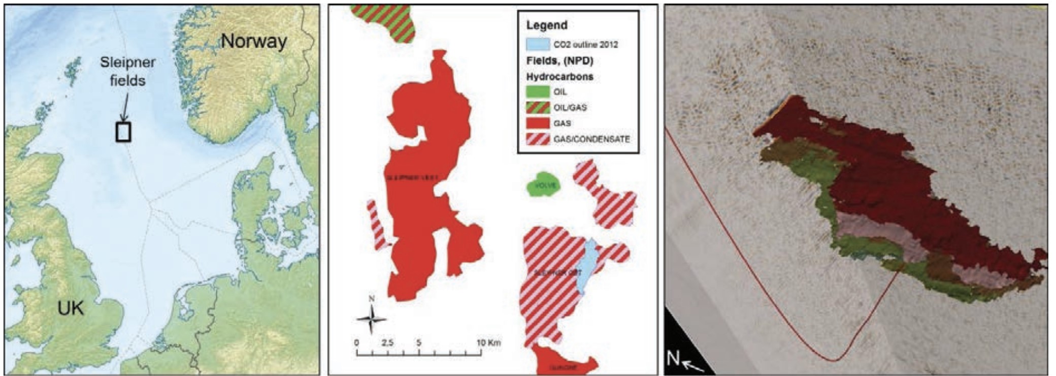
The Sleipner gas condensate field
The Sleipner Vest gas field (Figure 1) was discovered in 1974, and put on stream in 1996.
The Sleipner gas condensate field is located 250 km offshore the west of Stavanger, Norway in the block 15/9. The gas in one of the structures (Sleipner Vest) is containing 9% CO2 and has to be separated form the export gas to meet quality specifications. Until then the standard engineering practice had bee to vent separated CO2 into the atmosphere. As a result of a growing concern about the risk of climate change due to emissions of greenhouse gasses the Norwegian government introduced in 1991 a CO2 tax. As consequence Statoil, who was operating the field, deiced that the CO2 should be injected into the Utsira Sand.
Figure 1: Left: location map (courtesy of Uwe Dedering). Middle: the Sleipner fields with the outline of the CO2 plume in 2013 indicated (base map courtesy of NPD). Right: A seismic difference section illustrating the extent of the CO2 plume in 2013.
The Utsira Formation was deposited during the late Middle Miocene (~20 million years) to Early Pliocene (~14 million years), Eidvin et al. 2002. The formation belongs to the Nordland Group present in the Viking Graben (Gregersen and Michelsen 1997), area from ca. 58ºN to 62ºN (Figure 2). The Utsira formation is a highly elongated sand reservoir, extending for more than 400 km from north to south and between 50 and 100 km from east to west, with an 72 area of some 26 100 km2. The top Utsira formation and surface generally varies relatively smoothly, mainly in the range 550 to 1500 m, but mostly from 700 to 1000 m. There are two main depocentres. One is in the south, around Sleipner, where thicknesses range up to more than 300 m. The second depocentre lies some 200 km to the north of Sleipner. There the Utsira formation is locally 200 m thick, with an underlying sandy unit adding further to the total reservoir thickness (Chadwick et al., 2000). At the nearest the formation, lies some 60- 70 km, from the Norwegian coast.
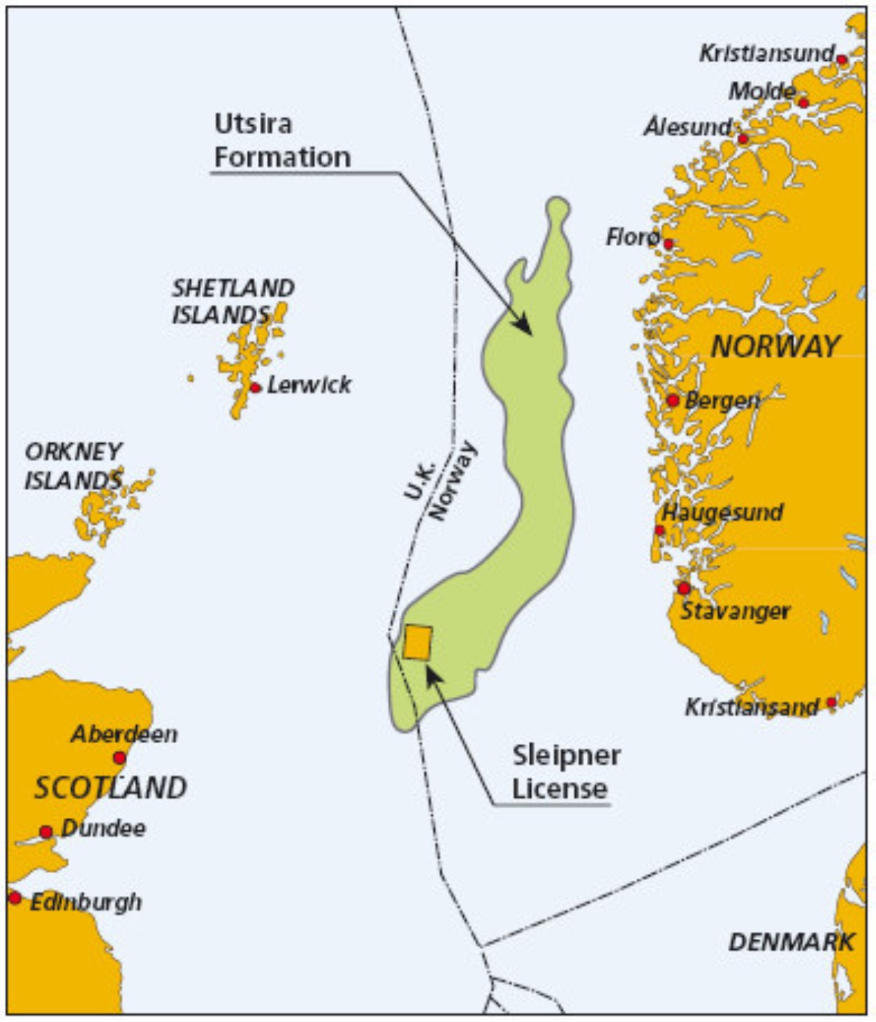
Figure 2. Location map showing areal extent of the Utsira Formation and the Sleipner licence.
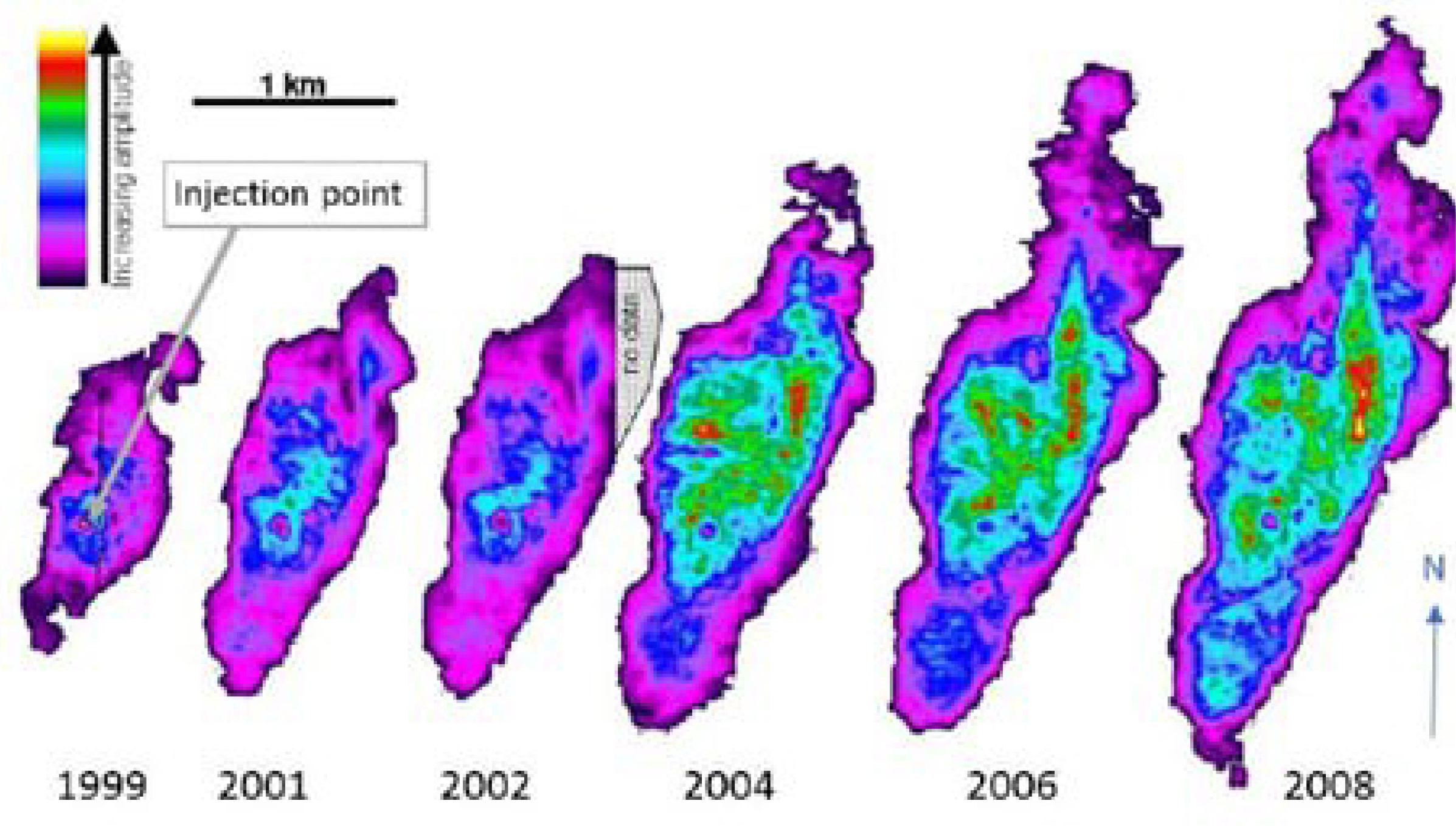
From well logs in Eidvin et al. (2002) it is estimated that 70% of the Utsira Formation is made of sand/sandstone. The Utsira Formation is overlain by Pliocene marine claystones of the upper part of the Nordland Group. The cap rock succession overlying the Utsira formation is rather variable, and can be divided into three main units, the lower, the middle and the upper seal (Torp and Gale, 2003). The lower seal extends well beyond the area currently occupied by the CO2 injected at Sleipner and seems to be providing an effective seal at the present time (Figure 3). Empirically, therefore, the caprock samples suggest the presence of an effective seal at Sleipner, with capillary leakage of CO2 unlikely to occur (Chadwick et al., 2000). The claystones are grey, sometimes greenish-grey and grey-brown, soft, sometimes silty and micaceous. The uppermost part of the Nordland Group consists of Pleistocene unconsolidated clays and sands, with glacial deposits uppermost (Isaksen and Tonstad 1989). The thickness of the seal is 500-1500 m. The seal on top of the Utsira Formation is assumed to be continuous across the area. In the east, the rocks are inclined such that stored CO2 would migrate eastwards and up towards the Pleistocene boundary.
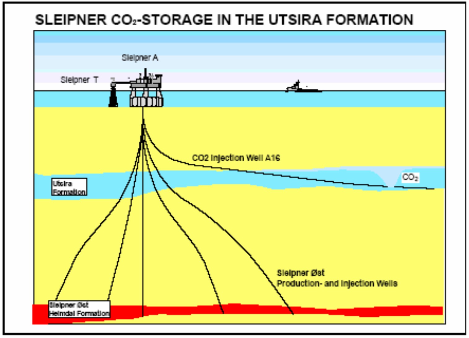
Figure 3. The Sleipner CO2 injection scheme. The Utsira formation is a 200 -250 meters thick and very permeable sandstone overlaid with mudstone. The CO2 capture takes place at the Sleipner T (Treatment) platform where it is also compressed. The highly deviated injection well has been drilled from the nearby Sleipner A concrete platform. (Source Statoil)
Saline Aquifer Carbon dioxide Storage (SACS) Project
The SACS project was a research and demonstration project which is monitoring and forward modelling the underground CO2 sequestration operation taking place at the Sleipner West gas field, offshore Norway.
The offshore gas field Sleipner, in the middle of the North Sea, has been injecting 1 Mt CO2 per year since September 1996 (Baklid et al., 1996). The CO2 is injected into salt water containing sand layer, called the Utsira formation, which lies 1000 meter below sea bottom. During 1998, a group of energy companies together with scientific institutes and environmental authorities in Norway, Denmark, the Netherlands, France and the UK formed the Saline Aquifer CO2 Storage (SACS) Project Consortium and started to collect relevant information about the injection of CO2 into the Utsira formation and similar underground structures around the North Sea. The SACS project involves a multidisciplinary approach. The different scientific disciplines involved in the project include: geology, geochemistry, geophysics and reservoir engineering/simulation.
In 1999 the SACS (Phase 1) project (supported under the European Commission’s Thermie Programme) started monitoring the CO2 behaviour and established a baseline by shooting a first 3D seismic survey (Gale et al, 2001), . The Phase 1 Project was extended to SACS2 in 2000 again with European Commission (EC) support. The SACS2 project, which terminated in 2003, continued the work undertaken in Phase 1 with further repeat 3D seismic surveys 74 completed to track the fate of the injected CO2. In addition, it is using the seismic data to verify available models and tools originally developed for hydrocarbons and water that have been applied to a CO2 and water system. The major difference being that CO2 is soluble in water and methane is not.
The goal of the SACS2 project was to develop a consensus about the monitoring results and validity of available models and tools. To develop such a consensus involves close coordination between the scientific institutes involved in the project. The cumulative experiences of the SACS projects are presented in a Best Practice Manual to assist other organisations planning CO2 injection projects to take advantage of the learning processes undertaken and to assist in facilitating new projects of this type. The document Best Practice Manual (Best Practice Manual, 2004) outlines the main findings of the SACS projects and this report reviews the document in this chapter.
CO2 storage quality and capacity
During the SACS-project, it has been shown that the Utsira Formation has good storage quality with respect to porosity, permeability, mineralogy, bedding, depth, pressure and temperature (e.g. Zweigel and Lindeberg 2000). It is a very large aquifer with a thick and extensive claystone top seal. The aquifer is, however, unconfined along its margins, and the time before migrating CO2 might reach the margins of the aquifer is unknown. The Utsira Formation is regarded as one of the most promising aquifers for CO2 storage in Europe. It has both such a considerable thickness and extent that it alone could store the CO2 emissions from all of the north European power stations and other large industrial plants for several hundred years (Torp & Christensen 1998). It is estimated that the Utsira Formation, below 800 m depth, has a pore volume of 918 km3, a storage capacity in traps of 847 Mt (mega tonnes) CO2, and that the storage capacity of the entire aquifer is 42 356 Mt CO2 with an assumption that storage volume representing 3 % the pore volume (See details in Bøe et al. 2002). The total pore volume of the aquifer is, however, estimated differently by other workers, 6.05 x 10¹¹ m3 (Kirby et al. 2001) and 5.5 x 10¹¹ m3 (Chadwick et al. 2000).
Sleipner North See CO2 ingection
Data source: Feasibility of Reproduction of Stored CO2 from the Utsira Formation at the Sleipner Gas Field. Idar Akervoll, Erik Lindeberga , Alf Lackner. 2009
Carbon Dioxide Storage: Geological Security and Environmental Issues – Case Study on the Sleipner Gas field in Norway. Semere Solomon. 2007
Следующее Месторождение: GUNGNE