Класс Месторождения: Мелкое
Тип Месторождения: Газоконденсатное
Местоположение:
Местность:
Стадия разработки: Добыча
Год открытия: 2003
Источник информации:
Метод открытия:
Площадь: 99.42 км²
South Batra field
South Batra field is located northern of El Mansoura City in the Nile Delta of Egypt between latitudes 31o2` & 31o9` N and longitudes 31o18` & 31o28` E.
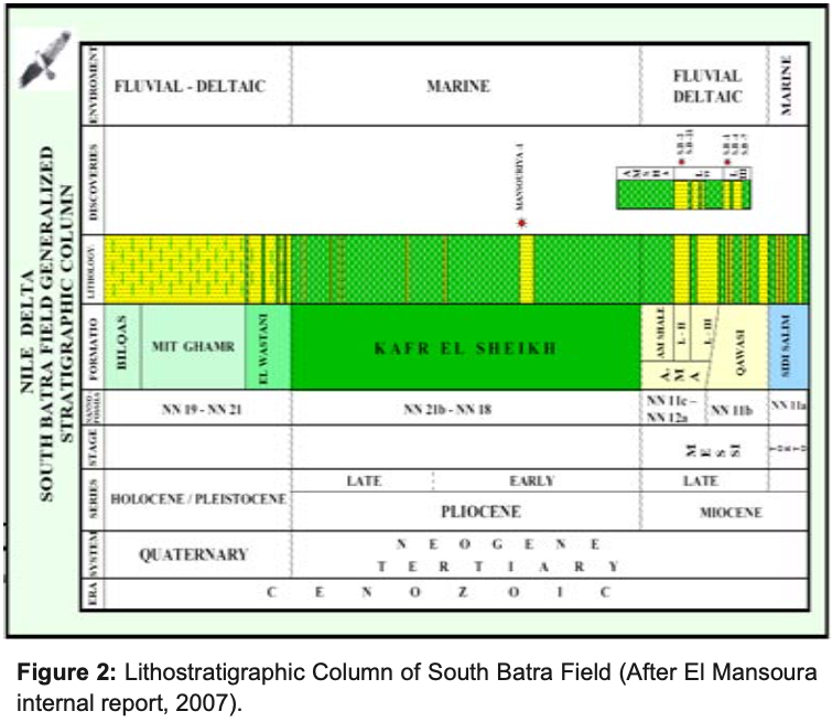
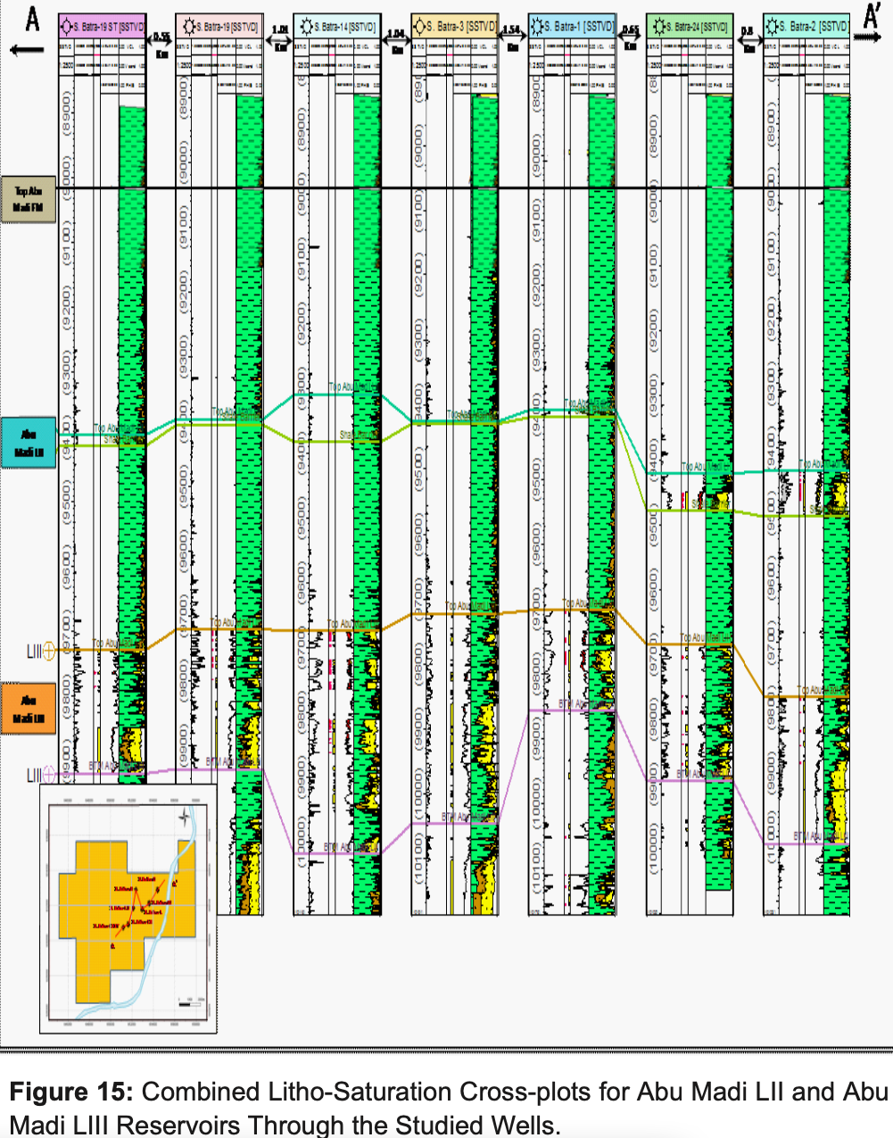
The stratigraphic sequence of South Batra Field comprises the following formations from bottom to top, Sidi Salim Formation (Langhian to Tortonian), Qawasim Formation (Tortonian-Messinian), Abu Madi Formation (Late Messinian), Kafr El Sheikh (Early to Late Pliocene), El Wastani (Late Pliocene- Early Pleistocene), Mit Ghamr (Pleistocene-Holocene) [4] (Figure 2). Abu Madi Formation consists mainly of sandstone intercalated with siltstone and shale interbeds. Based on the properties of the sandstone and the silt/mudstone facies, the Abu Madi sands could be divided into two main units (Level II & Level III). The sandstones of unit II is similar to unit III. However, it has greater regional extent as compared with the underlying basal unit III. Level–II consists of interbeds of sandstones or/and siltstones with shales streaks, the sandstones are fine to medium grained while Abu Madi shales are light grey, grey , which is reflect fluvio-marine environment. Level–III consists of interbeds of sandstones body with siltstones or/and shale streaks. Most probably, it is the thickest level in Abu Madi Formation. The sandstones are medium to coarse grained. (Abu Madi Formation sandstone is the zone of interest i.e. the most common gas/condensate bearing interval in Nile Delta region).
It represents the meandering fluvial channel and is overlaid by the marine shale of the Pliocene Kafr El Sheikh Formation while Abu Madi III represents the braided streams including interchannel bars. Unit II & unit III have good porosity and permeability characteristics and are considered to be the most common gas bearing intervals in the Nile Delta Region.
The Abu Madi Formation (Miocene section) is composed of Sandstones and Shale. The environmental conditions for the reservoir levels of Abu Madi Formation (Abu Madi Level II and Abu Madi Level III) are arranged in a transgressive vertical stacking pattern with a landward backstepping of the fluvial-coastal depositional systems and an overall shaling out to the north.
The depositional history of the Nile Delta basin has been influenced by multiple tectonic events and the Mediterranean sea- level fluctuations, which have both controlled sediment supply to the basin and accumulation space. Because of the Jurassic to Early Cretaceous, Tethyan rifting and the opening of Mediterranean, mixed clastic and carbonate shelf edges aggraded vertically along a steep fault-bounded shelf-slope break during the Cretaceous. The “hinge line” in Northern Egypt exerts the fundamental control on reservoir distribution in Tertiary age strata. The Tethyan rift margin was transpressionally inverted during the Syrian Arc Orogeny. The “hinge line” in Northern Egypt exerts the fundamental control on reservoir distribution in Tertiary age strata. The Tethyan rift margin was transpressionally inverted during the Syrian Arc Orogeny.
Renewed deltaic deposition began at approximately 3.8MA. The steep structural hinge line and faulted continental shelf created a large amount of accommodation space with relatively minor progradation of depositional systems (references). As a result, the primary play consists of slope-channel fairways in all levels. The Plio-Pleistocene systems are the shallowest targets in the basin, which hold the majority of proven reserves. The delta is divided into two sub-provinces by a faulted hinge line running WNW to ENE across the area at the latitude of the Kafr El Sheikh city (Figure 4). This hinge line is the most significant structural feature of the Nile Delta region and is known as the faulted flexure, which separates the south delta province from the north delta basin. In the southern delta province, the subsurface structures are complicated by the interaction between tectonic elements of different ages and with different orientations on these structures are superimposed. These are the ENE and NE trending folds of Late Cretaceous to Eocene age (The Syrian arc folds). The Oligocene to Early Miocene NW-SE trending faults, which were associated with a major uplift in the south coupled with basaltic extrusion.
 >
>
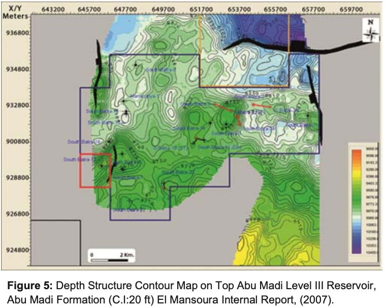
From the Oligocene to Recent, the Nile Delta has been the site of rapid accumulation of clastic sediment derived from a southward direction drainage system on the Afro-Arabian platform. The result is a 15,000 ft) thick wedge of the clastic sediments prograding northwards from the platform edge. The depth structure contour maps of Abu Madi level III reservoir, noticed gentle dipping towards the north direction. There is the E-W major fault parallel to the Hinge Line, throwing down to the north which is affected on this level with some minor faults in N-S direction (Baltim trend) that throwing down to the west. These faults created a four way dip closures of Abu Madi level III reservoir which had a geometric shape trending E-W and NE-SW directions. The highest depths for Top Abu Madi Level III within the study area in the eastern part of the S. Batra field are occurred at the central part (in S.Batra-1, S.Batra-14 and S. Batra-24) while the lowering in the depths towards the eastern part ( in S.Batra-2 and S.Batra-24). While the depth structure contour maps of Top Abu Madi Level II reservoir, showed that, there is a gentle dipping toward the north and the E-W major fault still affected on Top Abu Madi Level II with some minor faults in N-S and E-W directions on the eastern side of the field. Some small closures are existed where the drilled wells are penetrated; also we note that the channel trends of Abu Madi Level II in NE-SW direction as in Level III (Figure 6). From the above mentioned depth structure contour maps (Figure 5 & 6) the studied area is tectonically affected by a major deep-seated fault which is running in E-W direction, parallel to the hinge zone. This fault has affected the rock units form Oligocene to Intra Kafr El Sheikh Formation. This fault has made the northern part of South Batra area in the upthrown side of the fault, which gives a great possibility of hydrocarbon migration to this part, which is feeding the Abu Madi Reservoirs from the East Delta Field in the north, which is vertically sealed by the big thickness of Kafr El Sheikh Formation.

 >
>
 >
>

Следующее Месторождение: Marte (PSVM)